Vineyard (pearl mountain)
| Vineyard | ||
|---|---|---|
|
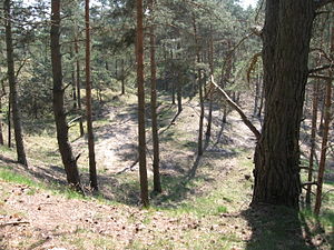
Landscape in the vineyards |
||
| height | 83 m | |
| location | Perleberg , Prignitz | |
| Coordinates | 53 ° 6 '17 " N , 11 ° 52' 3" E | |
|
|
||
| Type | ice age moraine | |
The vineyard (also: the vineyards ) is at 83 m the highest point in the city of Perleberg .
geography
Location and surroundings
The vineyard is an elongated elevation in the north of the city of Perleberg. It extends in a north-northeast direction between the Perlhof residential area and the Groß Buchholz district .
In the east runs the Reetzer Straße, which separates the vineyard from the northeastern Golmer Berg . The Stepenitz flows southeast . In the south, the pearl separates the vineyard from the Galgenberg . The Westprignitzer Kreisringbahn ran along the west side of the vineyard . Today the route is still marked by a forest path that separates the vineyard from the Klüssen Mountains .
height
The vineyard has several peaks, hence the name vineyards , which is also used . The highest point is 83 meters above sea level and thus rises about 50 meters above the Stepenitz lowland.
Flora and fauna
Today the vineyard is mostly forested.
A small part of the vineyard is designated as a nature reserve, Der Weinberg bei Perleberg . The decision was taken on March 11, 1971 by the Schwerin District Assembly. The nature reserve covers about 7 hectares.
There are numerous rare and protected plants in the nature reserve, including the common pasque flower and meadow pasque flower .
The vineyard is integrated into the 125.7 hectare fauna-flora habitat Weinberge-Klüssenberge near Perleberg and the Oser area near Perleberg .
history
Numerous pits of various sizes remind us that the vineyard was historically used as a source of building material (gravel). The gravel extraction also explains why the vineyard has a high relief energy , which is atypical for the Prignitz old moraine region.
Sheep grazed on the vineyard until the 19th century.
Before the Second World War , the vineyard was used as a glider flying site.
Origin of the name
The name of the mountain comes from the fact that wine was grown on its southern slope from the middle of the 16th century. Today the mountain is no longer used for this purpose. Since the vineyard has several peaks, the term vineyards is also used .
Monuments
In the northern part of the vineyard lies the grave of Peter Braun, who was innocently executed on October 12, 1850 on the nearby Galgenberg .
In the southern part of the vineyard there is a poorly preserved Schlageter monument.
Web links
Individual evidence
- ↑ Nature reserves in Brandenburg. (PDF; 166 kB) (No longer available online.) Ministry for the Environment, Health and Consumer Protection Brandenburg, December 2011, p. 4 , formerly in the original ; Retrieved September 5, 2012 . ( Page no longer available , search in web archives ) Info: The link was automatically marked as defective. Please check the link according to the instructions and then remove this notice.
- ↑ 3. Change of the land use plan. (PDF; 627 kB) Justification with environmental report. Stadt Perleberg, p. 32 , accessed on September 5, 2012 (version in accordance with the SIA's decision on September 22, 2011).
- ↑ a b c d Kuhschelle in the Prignitz. Prignitz district, accessed on September 5, 2012 .
- ↑ Areas of Community importance proposed by the State of Brandenburg in accordance with Directive 92/43 / EEC (FFH areas). (PDF; 407 kB) Ministry for the Environment, Health and Consumer Protection Brandenburg, p. 20 , accessed on September 5, 2012 .
- ↑ Ordinance on the "Osergebiet bei Perleberg" nature reserve. (PDF; 1.8 MB) Prignitz district, December 7, 2012, accessed on January 5, 2013 .
- ↑ Lieselott Enders : The Prignitz - History of a Kurmärkischen landscape from the 12th to the 18th century . 1st edition. Verlag für Berlin-Brandenburg GmbH, Potsdam 2000, ISBN 3-935035-00-4 , p. 503 .
- ↑ New plaque on Peter Braun's grave of honor. Perleberger Bürgererverein also wants to restore the hiking trail on the vineyard. (No longer available online.) Perleberger Bürgerverein eV, March 2, 2012, archived from the original on June 29, 2013 ; Retrieved on September 5, 2012 (source: extract from the Prignitzer of March 2, 2012). Info: The archive link was inserted automatically and has not yet been checked. Please check the original and archive link according to the instructions and then remove this notice.


