
Werdenbergersee
| Werdenbergersee | ||
|---|---|---|

|
||
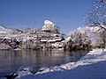
| Werdenbergersee with town and castle | ||
| Geographical location | Buchs SG , Canton of St. Gallen , Switzerland | |
| Tributaries | (unnamed) | |
| Drain | Wettibach → Giessen (Werdenberg Inner Canal) | |
| Places on the shore | Werdenberg ( Grabs ), Buchs SG | |
| Data | ||
| Coordinates | 753 538 / 226019 | |
|
||
| Altitude above sea level | 445 m above sea level M. | |
| length | 257 m | |
| width | 167 m | |

The Werdenbergersee is a lake in the Werdenberg region in eastern Switzerland part of the Alpine Rhine Valley .
geography
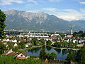
The Werdenbergersee is located at the foot of the Buchserberg, in the transition to the plain of the St. Gallen Rhine Valley . Politically, the lake belongs to the municipality of Buchs in the St. Gallen constituency of Werdenberg . On the northwestern bank, in the area of the political community of Grabs , is the historic town of Werdenberg , above which the castle of the same name towers.
history
The history of the Werdenbergersee is closely connected to the history of the nobles of Werdenberg and the county of Werdenberg .
In 1803 the "Werdenberg" came to the newly founded canton of St. Gallen . Buchs kept the Werdenbergersee. Werdenberg Castle and Werdenberg were awarded to the community of Grabs .
use
The Werdenbergersee is mainly used as a recreational area and for non-commercial fishing .
Sights and buildings
- The center of Werdenberg is a listed building
- Werdenberg Castle , with museum

In the spring

In summer
In the winter

View to the south
View to the west


Web links
Individual evidence
- ↑ a b geoportal.ch (please click on the coordinates), measured on February 12, 2016
- ^ Website of the Werdenberg region , accessed on May 24, 2015