
Wetterkoglerhaus
| Wetterkoglerhaus ÖAV hut category II |
||
|---|---|---|
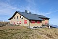
.JPG) West-southwest view of the Wetterkoglerhaus |
||
| location | at the summit of change ; Lower Austria / Styria ; Valley location: Mönichwald | |
| Mountain range | Change (mountain) | |
| Geographical location: | 47 ° 31 '49.6 " N , 15 ° 54' 52.3" E | |
| Altitude | 1743 m above sea level A. | |
|
||
| owner | Austrian Mountain Association of the PES | |
| Construction type | hut | |
| Usual opening times | Mid May to mid November | |
| accommodation | 6 beds, 36 camps , 8 emergency camps | |
| Winter room | 6 bearings | |
| Hut directory | ÖAV DAV | |

The Wetterkoglerhaus is an alpine club hut belonging to the Austrian Mountain Club of the ÖAV at an altitude of 1743 m , on the summit of the Hochwechsel on the border between Lower Austria and Styria .
location
The hut stands right next to the flat summit of the Hochwechsel and therefore offers a comprehensive panorama; among other things, it is ideal for observing thunderstorms. In the immediate vicinity there is a chapel where the ÖKB memorial mass takes place every year on August 15, regardless of the weather.
history
The first refuge was built in 1899 by the Alpine Society "D'Wetterkogler", a group of the Austrian Mountain Association . From 1912 a larger extension and a veranda were built at right angles to the existing hut and opened in the summer of 1913 as a new shelter that can be managed all year round and offers 35 beds. On November 21, 1915, the shelter burned down to the foundation wall. In 1923 a new Wetterkoglerhaus was built. This was expanded in 1930 with an addition for a second guest room and new bedrooms and in 1934 a ski room was added.
Accesses
- From Mönichkirchen from the mountain station via Niederwechsel or Vorauer Schwaig (approx. 3 to 4 hours)
- From Mönichwald by car to the Mönichwalder Schwaig toll station (throw in € 4.50 exactly), continue by car or on foot (approx. 2.5 hours)
- From Waldbach by car to the Rabl Kreuz Hütte toll station (throw in € 4.50 exactly), continue by car or on foot (approx. 1.5 hours)
- From the Mariensee car park either via the Schindelsteig or the Wasserfallweg to the Marienseer Schwaig (approx. 1.5 hours), then either along the trail via Feistritzer Schwaig to the 3-Länder-Eck (approx. 2 hours) or directly up (approx. 45 min. )
- From Kirchberg am Wechsel by car to Steyersberger Schwaig, then on foot (approx. 1.5 hours)
- From St. Corona via the Kampsteiner and Feistritzer Schwaig (approx. 3.5 to 4 hours)
The Wetterkoglerhaus is also located on Zentralalpenweg 02 as well as on Eastern Austrian Grenzlandweg 07 , two Austrian long-distance hiking trails.
gallery
Southeast view

Northeast view
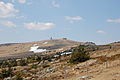
High change
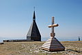
Weatherproof summit cross and chapel
.JPG)


literature
- Erika Sieder, Vroni Marx (ed.): 120 years of the Wetterkoglerhaus. A checkered history , Verlag Bibliothek der Provinz , Vienna 2019, ISBN 978-3-99028-851-1 .
Web links
Individual evidence
- ↑ Imo Eberhard Irsay: Wetterkoglerhaus. Austria-Forum, ServusTV, June 28, 2012, accessed on October 18, 2012 .
- ↑ The new Wetterkogler shelter on Hochwechsel (1783 meters). With a photograph. In: Wiener Bilder , No. 30/1913 (18th volume), July 27, 1913, p. 11 center. (Online at ANNO ). .