Weyerberg (Worpswede)
| map |
|---|

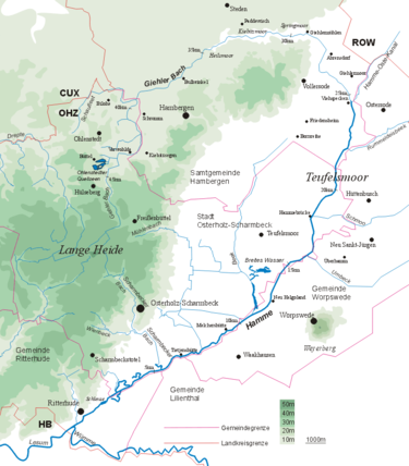
The Weyerberg in its position on the Teufelsmoor and the river system of the Hamme
|
The Weyerberg ( Plattdeutsch Weyerbarg ) is, according to some sources, 54.4 meters high, consisting of sand, Geestinsel in the Teufelsmoor near the village of Worpswede in the Osterholz district in Lower Saxony . The Weyerberg was probably formed at the end of the penultimate glacial period ( Saale complex ), when flowing meltwater washed away the glacifluvial sands attached to its clay core to the rest of today's Weyerberg. With a relative height of about 48 meters between the surrounding almost flat Teufelsmoor and its 50.7 meter high summit ( Hohes Feld ), it is one of the most striking elevations in the Lower Saxony lowlands.
Neolithic stone tools and jewelry have been found on the hilltop and in its vicinity. From 1100 BC Urn graves were discovered on the southern slope (corridor Hinterm Berg ). 500 BC The mountain was abandoned as a settlement area because the climate cooled down.
Worpswede was first mentioned in a document in 1218, as the eight farms at that time owed the tithing to the Osterholz monastery . The name Worpswede means something like wooded hill ("worp" = hill, the thrown up; "wede" = forest, wood, wood).
On the Weyerberg stands the Niedersachsenstein , a brick monument by Bernhard Hoetger .
In 1957 the Worpswede Foundation was established, which tries to prevent further sand mining on the Weyerberg by buying up land.
Individual evidence
- ↑ Worpswede.de ( Memento of the original from February 13, 2010 in the Internet Archive ) Info: The archive link was inserted automatically and has not yet been checked. Please check the original and archive link according to the instructions and then remove this notice.
- ↑ Environment map service of the Lower Saxony Ministry for the Environment, Energy and Climate Protection ( information )
literature
- Hans-Gerhard Kulp: The Weyerberg and the Teufelsmoor. A landscape ecological guide. Ed .: Biological Station Osterholz, Verlag M. Simmering , Lilienthal 1995, ISBN 3-927723-25-8 .
- Wendula Dahle (Ed.): In the land of moors and dykes. Excursions left and right of the Weser. A travel and reading book. 5th edition. Edition Temmen , Bremen 2005, ISBN 3-86108-466-X .
Coordinates: 53 ° 12 '58 " N , 8 ° 55' 25" E