White City (London Underground)
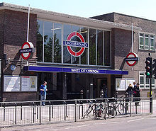
White City is an above-ground London Underground station in the London Borough of Hammersmith and Fulham . It is in the Travelcard tariff zone 2 on Wood Lane. In 2014, 7.51 million passengers used the station served by the Central Line .
investment
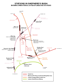
Diagonally across the street is the BBC Television Center , the broadcasting center of the British Broadcasting Corporation . Also nearby is Loftus Road , home of the Queens Park Rangers football club . The Central Line's inner city tunnel begins immediately south of the station. In contrast to the rest of the network, which has left-hand traffic, the trains here run on the right-hand track. The reason is the Wood Lane station, a little further south, which has now been closed and which was opened in 1908 as the western terminus at the time and built in the form of a turning loop. Halfway to the next station, East Acton , the two main tracks cross and change back to left-hand traffic. The station itself has three tracks, with the middle track being delimited on both sides by a platform and thus accessible by trains from both directions. Turning trains can reach the White City depot from here.
history
The station opened on November 23, 1947 on the line that had been in existence since 1920. White City was to replace Wood Lane station a little further south . Construction began in 1938, but was suspended for several years because of the Second World War. The architectural design of the station received an award at the Festival of Britain in 1951 , as a commemorative plaque at the main entrance.
In the immediate vicinity, the Wood Lane station on the Hammersmith & City Line has been in operation since 2008 . On the one hand, this means that the Westfield London urban development project will be better developed, and on the other hand, there has been a transfer option since then.
Web links
- Photo of the station building (1951). London Transport Museum, archived from the original ; accessed on September 3, 2018 .
Individual evidence
- ↑ COUNTS - 2014 - annual entries & exits. (PDF, 44 kB) Transport for London, 2015, archived from the original ; accessed on September 3, 2018 (English).
- ↑ Central Line. Clive's Underground Line Guides, accessed September 3, 2018 .
- ↑ Wood Lane and Shepherd's Bush Market to join Tube map. TfL , November 20, 2006, archived from the original ; accessed on September 3, 2018 .
| Previous station | Transport for London | Next station |
|---|---|---|
| East Acton |
|
Wood Lane (closed) |
Coordinates: 51 ° 30 ′ 42.8 " N , 0 ° 13 ′ 27.3" W.

