Whitefish River (Great Bear Lake)
| Whitefish River | ||
|
|
||
| Data | ||
| location | Northwest Territories (Canada) | |
| River system | Mackenzie River | |
| source | in a ridge southwest of the Großer Bärensee 65 ° 23 ′ 27 ″ N , 123 ° 12 ′ 11 ″ W |
|
| Source height | approx. 480 m | |
| muzzle | to Bydand Bay ( Great Bear Lake ) Coordinates: 65 ° 55 ′ 0 ″ N , 124 ° 48 ′ 7 ″ W 65 ° 55 ′ 0 ″ N , 124 ° 48 ′ 7 ″ W |
|
| Mouth height | 156 m | |
| Height difference | approx. 324 m | |
| Bottom slope | approx. 2.5 ‰ | |
| length | approx. 130 km | |
| Catchment area | > 4740 km² | |
| Discharge at the gauge near the mouth of the A Eo : 4740 km² |
MQ 1977/1992 Mq 1977/1992 |
14 m³ / s 3 l / (s km²) |
|
Location of the Whitefish River |
||
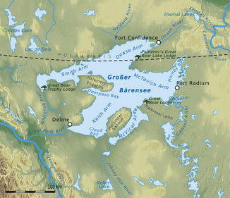
The Whitefish River is a tributary of Great Bear Lake in the Northwest Territories of Canada .
The Whitefish River rises 25 km north-northeast of Déline in a ridge southwest of the Great Bear Lake at an altitude of about 480 m . It initially flows north, later turns west, before the river in the lower reaches turns north-northwest and flows into Bydand Bay in the extreme southwest of the Smith Arms . The Whitefish River has numerous tight meanders . It has a length of about 130 km. The catchment area covers over 4740 km². At the lower reaches there is a discharge level that provides an average discharge of 14 m³ / s.
Individual evidence
- ↑ a b Whitefish River at the gauge near the mouth - hydrographic data from R-ArcticNET
