Wichtshausen
|
Wichtshausen
City of Suhl
Coordinates: 50 ° 36 ′ 2 ″ N , 10 ° 34 ′ 23 ″ E
|
|
|---|---|
| Height : | 361 m |
| Area : | 6 km² |
| Residents : | 522 (Jan 31, 2015) |
| Population density : | 87 inhabitants / km² |
| Incorporation : | April 1, 1994 |
| Postal code : | 98529 |
| Area code : | 036846 |
|
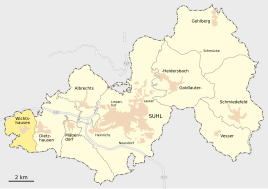
Location of Wichtshausen in Suhl
|
|
|
Rectory
|
|
Wichtshausen has been a district of the independent city of Suhl in the Free State of Thuringia ( Germany ) since 1994 .
Geographical location
Wichtshausen is located in the southern Thuringian Forest west of Suhl, on the road to Meiningen in the Hasel Valley. The district has an area of 6.0 square kilometers.
history
The place was first mentioned in a document in 799. Wichtshausen belonged to the county of Henneberg and was in the Saxon office of Kühndorf until 1815 . During the Thirty Years' War the place was badly damaged. a. The church and rectory also burned down. The church was restored and looked after by the pastor from Albrechts . In 1710 Wichtshausen became a parish in a parish together with Dillstädt .
From 1816 to 1944 Wichtshausen was part of the Erfurt administrative district of the Prussian province of Saxony . On April 1, 1994 it was incorporated into Suhl. In 2002 a club house was created for the citizens of the Suhl district.

