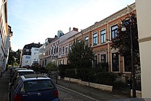
Residential building group St.-Pauli-Straße
The St.-Pauli-Strasse residential group is located in Bremen , Mitte district, Ostertor district , St.-Pauli-Strasse 54 to 58. The ensemble was created around 1900. The residential group has been a listed building since 1973 .
The curved St.-Pauli-Straße leads in a west-east direction and then in a north-south direction from Ostertorsteinweg to Deichstraße and crosses or touches Poststraße (notary Hermann Liborius Post (1803–1886)), Theodor-Körner -Straße, Alexanderstraße / Köpkenstraße (Köpkenstift from 1564), Kreuzstraße / Bleicherstraße . It was named after the Paulskloste the Benedictines and the Paul Berg district.
history
The Paulskloster from 1050 was demolished in 1523 for strategic reasons and the Paulsberg was demolished a century later.
In 1849 areas of the Ostertor district were incorporated and the citizens were given full citizenship of Bremen. It was reinforced after the lifting of the gate .
The two plastered, three-axle, two-storey houses and the faced three-storey building, all designed from 1900 in the style of historicism , are typical Bremen houses with saddle roofs and friezes .
The State Office for Monument Preservation Bremen wrote: "The terraced houses at St.-Pauli-Straße 54/58 replaced a previous building at this point around 1900 and, as a group of three with a central building raised by one storey, form a design unit."
The house type Bremer Haus , which occurs frequently in the district , was built in Bremen between the mid-19th century and the 1930s. The basement as a basement , the deep building shape and the side entrance are characteristic.
Today (2018) the houses are still used for residential purposes.
literature
- Johannes Cramer, Niels Gutschow: Historical development of the Bremen house . In: The Bremen House. History, program, competition , Bremen 1982.
- Hans-Christoph Hoffmann: The Bremen House . Bremen 1974.
Individual evidence
Coordinates: 53 ° 4 ′ 16.1 ″ N , 8 ° 49 ′ 9.7 ″ E


