Ostertorsteinweg
| Ostertorsteinweg | |
|---|---|
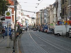
| Street in Bremen | |
| Between Ulrichsplatz and Sielwallkreuzung | |
| Basic data | |
| city | Bremen |
| District | Easter Gate |
| Created | Street in the middle ages, |
| Newly designed | 1990s |
| Cross streets | Contrescarpe , St. Pauli Passage, Mozartstr., Mittelstr., Sankt-Pauli-Str., Poststr., Hohenpfad, Ulrichsplatz , Blumenstr., Weberstr., Bauernstr., Schildstr., Sielwall , Am Dobben |
| Buildings | Puls-Eck office building, Ostertorsteinweg 68 residential building |
| use | |
| User groups | Tram , cars, bikes, pedestrians |
| Road design | two-lane road, two tram tracks |
| Technical specifications | |
| Street length | 1000 meters |

The Ostertorsteinweg is a historic street in Bremen , Mitte district, Ostertor district . It leads in a west-east direction from Am Wall / Goetheplatz to the Steintor district with the street Vor dem Steintor .
Ostertorsteinweg is an important shopping street with many shops and specialty shops as well as restaurants and pubs. The quarter festival takes place once a year on Ostertorsteinweg .
The cross streets and connecting streets were named u. a. as Am Wall , Contrescarpe , St. Pauli Passage (see below), Mozartstraße , Mittelstraße from 1853 according to the location, Sankt-Pauli-Straße from 1858 according to the St. Paul monastery , Poststraße from 1847 according to the notary of the city Hermann Liborius Post (1803–1886), Hohenpfad after the higher Dammweg, Ulrichsplatz after the writer, Karl Heinrich Ulrichs , Wulwesstraße (1721 Mühlenstraße), Blumenstraße from 1819, Weberstraße from 1854, Bauernstraße after the Steinstraße farmers, Schildstraße from 1874 after a building contractor, Am Dobben , Sielwall from 1861 to the local Wesersiel and on the stone gate (to 1870 stone gate Steinweg ); otherwise see the link to the streets.
history
Surname
The street and the district were named after the Ostertor , the former east (er) gate of the Bremen city wall . The Easter gate as valva orientalis civitatis nostre in the east was first mentioned in 1238 and expanded into an Easter kennel in 1512/14.
development
11th to 18th centuries
In the Middle Ages, a trade route led from the Domburg in Bremen on the dunes along the Weser in the direction of Verden . In 1050, the Benedictine monastery of St. Paul was built on one of the dune hills , and today the names Paulistraße and Am Paulskloster remind of it.
With the construction of the city wall , the Easter Gate - the valva orientalis civitatis nostre - whose gate tower, built in 1238, stood until the early 19th century and was also called "the bell". A settlement of craftsmen and traders had formed around the Paulskloster early on, "suburb in front of the Easter gate, built like a small town with wooden houses and some stone houses". It was protected by the Landwehr am Dobben with the stone gate , but because of the location in front of the city wall, there were building restrictions.
With the construction of a wall in front of the wall, the Easter kennel was built in front of the old gate tower in 1512/14 . In 1523 the St. Pauli monastery and a hundred years later the hill on which it had stood were demolished so as not to offer any cover to any attackers. At the beginning of the 17th century the suburb was called "St. Pauli suburb". Corresponding to the description three hundred years earlier, the city maps of the 17th century also show lines of closed buildings along the “Osterthors-Steinweg”. The Ostertor bastion was placed in front of the wall during the Thirty Years' War .
19th century

Since 1802/04 the ramparts have been softened and redesigned like a park, the street course has been straightened after the bastion has been leveled and a small guardhouse was built. The two representative gate buildings that still exist today were only built between 1825 and 1828 and are now used as exhibition rooms. The Ostertorzwinger was demolished in 1826, the wall gate in 1828. Towards the city center of the new gate building, the Bremen art gallery was built from 1847 to 1849 . In 1848 the nocturnal gate lock and the collection of the excise at the city gate were dropped . In the following years, the one to two-storey gabled houses of the old suburban buildings were replaced one by one with eaves houses in the style of historicism . In contrast to other Bremen houses , they had shops, which meant that the otherwise typical basement was omitted. Only house number 13 remained.
20th and 21st centuries
The theater on Goetheplatz was built on the border between Wallanlagen and business street and opened in 1913.
The street was spared from destruction during the Second World War . The non-renovated buildings led to a structural change in the population of the district; poorer sections of the population moved in.
In order to relieve traffic in the city center of Bremen, a "tangent square" should be built around the city according to the traffic plans. The road bypasses in the west and past the train station in the north had been created. In the east, a street from Rembertiring at Mozartstrasse was to cross Ostertorsteinweg and then the Weser in a bridge position. This Mozart route , which was planned in the 1960s, was abandoned in the early 1970s due to pressure from the population. Instead, the district was the first Bremen area to be included in the urban development subsidy program and was thoroughly renovated between 1973 and 1990.
The social structure of the population changed due to its close proximity to the historic city center and due to urban renewal . Well-paid employees, many academics, but also students and citizens with a more alternative lifestyle moved in and a street with older houses and young citizens developed.
As early as the 1960s, the Sielwallkreuzung area at the end of Ostertorsteinweg was a local center with the scene and jazz bar Lila Eule , the arthouse cinema Cinema Ostertor , but also with a drug scene and sometimes excessive riots.
During the last renovation of the Ostertorsteinweg carriageway in 2007, small pavement was used from the Sielwallkreuzung to the Goetheplatz stop towards the city center to the right of the tram tracks to make cycling easier.
traffic
In 1879 a horse-drawn tram line from Hastedt to Walle was opened through Ostertorsteinweg and electrified around 1900. The Ringbahn was added in 1881. In 1908 line numbers from 1 to 8 were introduced.
The Bremen tram crosses the street today with lines 2 ( Gröpelingen - Sebaldsbrück ) and 3 (Gröpelingen - Weserwehr ).
Buildings and plants
The street is characterized by three to six-storey buildings.
The State Office for Monument Preservation Bremen wrote: "Apart from a few disturbances, the Ostertorsteinweg shopping street has survived to this day as it had developed up to World War I ... a heterogeneous, but also attractive picture of a shopping street."
Listed buildings:
- No. 1/2: 4-ply Neoclassical Beye and Fahl office building from around 1910 based on plans by Werner Heyberger ; see monument database of the LfD
- No. 6: 3-sch. Residential and commercial building of the delicatessen store Wilh. Holtorf from around 1910 in reform style; see monument database of the LfD
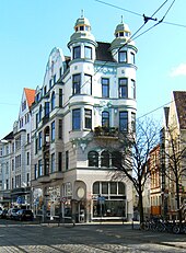
- No. 68/69, corner of St.-Pauli-Straße : 4-storey. Residential house Ostertorsteinweg 68 from 1905 in the reform and art nouveau monument database of the LfD
-
Residential houses Ostertorsteinweg 73/75
- No. 73: 3-sch. historicizing residential and commercial building in the neo-renaissance style from around 1890 monument database of the LfD
- No. 74/75: 3-layered historicizing (neo-renaissance) residential and commercial building Dunkel from 1871 Monument database of the LfD
-
Residential houses at Ostertorsteinweg 86 to 90 Monument database of the LfD
- No. 86: 4-sch. historicizing residential and commercial building from around 1880
- No. 87: 4-sch. Historicizing residential and commercial building by Georg Ahlers from 1904/05 based on plans by Hans Lassen
- No. 88/89: 4-cut. Residential and commercial building from 1904/05 based on plans by Hans Lassen in reform style
- No. 90 / 90a: 4-layered Residential and commercial building from around 1905 in reform style
- No. 100 to 107: 2- to mostly 3-layered Historicized residential and commercial buildings as a group of residential buildings at Ostertorsteinweg 100 to 107 and as individual buildings from around 1860, 1870 and 1890
More buildings
- No. 13: The oldest single-storey house in the street and the district is not - as the facade is overformed - under monument protection; today housewares business
- No. 50, corner house to Contrescarpe: 4-storied. Investment pulse-Eck from 1955, designed by Martin Zill
Monuments and fountains
- Bronze sculpture Ottilie Hoffmann from 1987 by the sculptor Jürgen Cominotto on the corner of Wulwesstrasse
- Horse fountain I from 1900 by Gerhard Lange on the corner of Contrescarpe and Goetheplatz
See also
literature
- Dietrich Schomburg : The Bremen Ostertorvorstadt in its historical-topographical development , Part II: About the development of the Ostertorsvorstadt in the Middle Ages . Bremisches Jahrbuch , 46, Bremen 1959, pp. 251–266.
- Holle Weisfeld: Ostertor - stone gate 1860–1945 . Edition Temmen, Bremen 1998, ISBN 3-86108-608-5 .
Web links
Individual evidence
- ↑ The mouse e. V .: Klinghe, Berend ( Memento of the original from January 19, 2015 in the Internet Archive ) Info: The archive link was inserted automatically and not yet checked. Please check the original and archive link according to the instructions and then remove this notice.
- ↑ BUB, Vol 3, No. 141 (page 120 /.. 121 ) : plateam dictam Stenstrate ; “Platea” was the common name for cobbled streets at the time
- ↑ Rynesberch Chronicle , chap. Gotfridus, the 35th erczbisscup to Bremen
- ↑ Urbis Bremae Typus et Chronicon , p. 48 u. Tab.XVI: 1 = turris S. Viti, 2 = (mons &) suburbiũ S. Pauli
- ↑ Monument database of the LfD Bremen
Coordinates: 53 ° 4 ′ 22 " N , 8 ° 49 ′ 23" E


