
Bremen streets
| Bremen streets | |
|---|---|
|
|
|
 |
|
| Obernstrasse , 1844 | |
| Basic data | |
| place | Bremen |
.jpg)

The Bremen streets form the street network of the city of Bremen and in 2018 comprised more than 5300 municipal inner-city streets with a total length of around 1400 kilometers. They are shaped by the historic town centers in Bremen's old town and today's Vegesack district in Bremen- Nord , as well as by the later expansion of the city along the Weser . Because of the elongated structure of today's urban area and the large extent of Bremen with around 43 kilometers from Farge in the north to Mahndorf in the east, the streets of Bremen are often relatively long in the north-west-south-east direction.
The road network is mostly oriented towards the two main directions north-south and east-west. The oldest streets date from the 10th century, but were only mentioned in documents later. Bremen's longest street is the 7200-meter-long Waller Straße , which runs through several parts of the city and district in the West district . Kornstrasse , located in the southern district of Bremen Neustadt , has the highest house number with number 648.
The known streets are listed in alphabetical order as Wikipedia articles in the inner city street category in Bremen . The articles show the meaning of the street names and their intersecting and connecting streets.
General
There are currently a total of 5310 streets in the city of Bremen (as of December 2018). Its total length is around 1400 kilometers. While many streets “bear the names of mayors, surrounding communities or even fairy tale characters, those of women are rare”: only a little more than 80 streets are named after female personalities. Since the end of the 2000s, there have been various political and social initiatives to give more consideration to women when naming streets. The advisory boards , which - according to local law - have the right to propose street names, continue to implement the suggestion hardly or only hesitantly.

The Böttcherstraße , located near Bremen's market square , is one of the cultural monuments and tourist attractions in Bremen due to its architecture and is known as “the city's secret main street”. In addition, with a length of 108 meters, it is the shortest street in Bremen.
There are numerous streets, paths and squares that have "only one house number", such as those with names that begin with the letter "A" (as of December 2018): Allensteiner Straße in the garden city of Vahr , Alnokweg in Arbergen , the street Alter Schulweg in Fähr-Lobbendorf , the square Am Hohentorsplatz in Hohentor , the street Am Stadtwaldsee in Lehe and the Anton-Tucher-Straße in Hemelingen .
There are also numerous streets and paths in Bremen that are "without official development ". These are mostly streets and paths in parks, green spaces and allotment garden areas, etc., connecting paths in residential areas, streets and paths in commercial, industrial and port areas as well as motorway slip roads and the like.
Main shopping streets in Bremen as pedestrian trained Obernstrasse and Sögestraße and their environment with partly covered shopping arcades in the city center. Obernstrasse is one of the "25 most-visited shopping streets in Germany" (April 2018: 14th place).
history
The approximately 23 kilometer long dunes from Bremen- Burg to Mahndorf shaped the first settlement and the road network of Bremen. To the north of the Lesum , the south ridge of the Osterholzer Geest joins a settlement band from Bremen-Nord to Schwanewede , with partly steep slopes towards the Weser .


Bremen was first mentioned in 780 and was still a very small place at that time. At the highest point of the dune, a wooden church was built around 789 as Bremen's first cathedral . The construction of today's cathedral followed in the 13th century. Around the seat of the Archbishop in the Archdiocese of Bremen , the place that received market rights in 888 grew from 848/849 . The market took place on the bank of the Belge and above; probably already on the upper surface of today's Bremen market square. From the Domburg and the Markt a network of streets developed with Obernstrasse , Langenstrasse and Sögestrasse as well as the square at the Marktkirche St. Vitus, which later (1220) was called Liebfrauenkirche , with the Unser Lieben Frauen Kirchhof . In the early Middle Ages, Bremen developed into a civitas Bremensis with city rights as a Free Imperial City in 1186 . A road network was created between the Weser and the Bremen city wall from 1229, which initially only comprised the eastern old town up to today's street Nicolai Straße - Hankenstraße - Straße Fangturm. In the 13th century, Bremen expanded towards the west and now consisted of four parishes .
Stephaniviertel: The parish of St. Stephani , around 1139, today's Stephaniviertel , was only included in the city fortifications from 1307 with the Stadtmure umme sunte Steffens . There were already streets around the Stephanikirche. The only connection between the two old town areas was the gate, the Natel (also known as the needle ) from 1284, a bottleneck in local traffic. The Faulenstraße was first mentioned in 1365. The inner wall between the two urban areas disappeared in 1551 and the gate at the end of Langenstrasse only shortly before 1660. The road connections between Stephaniviertel and the old town were established.
Dismantling of the fortifications: From 1802 to 1811 the fortifications were removed, the Bremen ramparts were built and the Contrescarpe was built on in the 19th century.
On the Neustadt side, there was hesitant settlement in the fortified area in 1623. The u. a. Neue Allee (today the northern part of Langemarckstraße ), Braut-, Grünen-, Süder-, Wester- and Osterstraße and a right-angled street network with the market (square) in the Newestatt (today Lucie-Flechtmann-Platz ), the horse market (today Neuer Markt ) and the Green Camp were created. The fortifications were dismantled from 1805, the Neustadt walls were built and the Neustadt contrescarpe was settled.
Heerstraßen: In the French era of Bremen around 1812 and afterwards, existing roads, roads and country roads were expanded into military roads and later named as u. a. the Arberger highway , Arster highway , Bremer Heerstraße , Bremerhaven highway , Burger highway , Grambker highway , Gröpelinger highway , Hastedter Heerstraße , Hemelinger highway , Horner Heerstraße , Huchtinger highway , Kattenturmer highway , Leher Heerstraße , Lilienthaler highway , Mahndorfer highway , Oberneulander highway , Oslebshauser Heerstraße , Osterholzer Heerstraße , Schwachhauser Heerstraße , Sebaldsbrücker Heerstraße , Waller Heerstraße and Warturmer Heerstraße .
Ringstrasse: The traffic planning of the building director Alexander Schröder in the 1860s / 70s envisaged a ring road ( Schröderring ) around the core of the city, to which the Waller Ring , Osterfeuerberger Ring, Utbremer Ring , Schwachhauser Ring , Kirchbachstrasse and Stader Strasse belonged and the except for a street through the Bürgerpark. In the 1920s and 1950s, the Ringstrasse idea for Bremen to the left of the Weser was expanded to include Georg-Bitter-Strasse , the bridge over the Weser (today Karl-Carstens-Brücke ), habenhauser Brückenstrasse , Neuenlander Strasse and Oldenburger Strasse (today federal road B 75) .
Road breakthroughs: The new railway lines and the first Hanover railway station created the new Kaiserstraße by 1875 , which led to the new Kaiserbrücke over the Weser in the direction of Neustadt . Several streets had to give way for this road breakthrough separating the old town, and Langenstrasse was divided for the first time. In 1902, for traffic-related reasons, the Am Brill square was expanded as a junction between Kaiserstraße (today mayor-Smidt-Straße ), Hutfilterstraße and Am Neuen Weg / Faulenstraße. In 1952 the new Bürgermeister-Smidt-Brücke was added to replace the destroyed Kaiserbrücke .

From 1953 to 1961/62 the Martinidurchbruch was created as a new Martinistraße between Am Brill and Große Weserbrücke , which significantly interrupted the old Langenstraße and clearly separated both the Obernstraße shopping area and the city center around the market square, town hall and cathedral from the Weser.
The Mozarttrasse planned in the 1950s / 60s in the Ostertor district and in the Neustadt ( near Kirchweg ) as part of a ring road was not built after massive protests by citizens and parts of the Bremen SPD (local associations Old Town, Neustadt, Buntentor); What remains is the Rembertiring intended for this.
In Vegesack , which came to Bremen in 1803 and developed as a central medium-sized center in Bremen-Nord, there are u. a. the pedestrian zones and shopping streets from Sedanplatz to Vegesacker Bahnhofsplatz as Gerhard-Rohlfs-Straße from after 1780 and Reeder-Bischoff-Straße from 1780 and u. a. the Alte Hafenstrasse from the 17th century and the Weserstrasse from after 1780.
City districts: The road networks of most city and districts are often based on older country roads, of which the cross streets mostly open up the area at right angles. In Huchting, a ring road consists of Kirchhuchtinger Landstrasse , Huchtinger Heerstrasse and the new Heinrich-Plett-Allee .
As supra-local roads , not detailed here, Bremen crosses various motorways and federal highways :
- Motorways A 1 , A 27 , A 270 (Bremen-North) and A 281 (Bremen-South)
- Federal highways B 6 , B 6n , B 74 ex. B 74n (Bremen-North) and B 75 (Bremen-South)
- Historical city maps (from the 16th to the 20th century) show the increasing expansion of the city and the road network
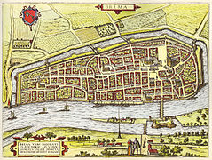
Hogenberg Plan 1588/89

Dilich Plan 1603

Merian Plan 1641: Below the old new town

Murtfeldt Plan 1796

Vegesack 1860

Verlag Karl Baedeker : Bremen / Bremerhaven city map 1910


Streets of the old town
.jpg)
.jpg)

.jpg)
The old town streets are of particular importance because of their central location and their history. Were mentioned for the first time
- the following streets in the longitudinal direction :
- Obernstraße , known as “platea superior civitas” in 1157 and as Overenstrate in 1374 , today a pedestrian zone and main shopping street
- Langenstrasse , 1234 as longa platea
- Schnoor , 13th century, pedestrian street and city quarter
- Schlachte , 1250 as slait , way at the quay fortifications, today Weser promenade
- Lower , 1333 than Tivera , today the waterfront
- Faulenstrasse , 1365 as Vulenstrasse
- Geeren , in the Middle Ages, street in the Stephaniviertel from the 11th century.
- Knochenhauerstraße , 1374 as Knokenhowerstrate , today pedestrian street
- Hutfilterstrasse , 1455 as Hotfilterstrate
- Bowl basket , known as Scottelkorf in the 15th century
- Violenstrasse in the Middle Ages border of the Cathedral Island
- Am Brill , in the 17th century as the street Hinter dem Brill
- Am Wall , 1802
- as well as Herdentorwallstraße, Lloyd-Passage , Queerenstraße, Pelzerstraße,
- as well as the following streets in the transverse direction :
- Sögestraße , named in 1261 as patea porcorum and 1306 as Soghestrate , today a pedestrian street
- Böttcherstraße , in the Middle Ages, now a pedestrian street
- from Obernstraße and Hutfilter Straße: Kleine and Große Waagestraße, Kahlenstraße, Pieperstraße, Papenstraße, Carl-Ronning-Straße, Kleine Hundestraße, Short Pilgrimage, Ansgaritorwallstraße
- from Bonehauerstraße: Carl-Ronning-Straße, Kleine Hundestraße, Papenstraße, Herdentorwallstraße
- from bowl basket: Museumstrasse, Katharinenstrasse
- from Faulenstrasse: Hankenstrasse, Wenkenstrasse, Ölmühlenstrasse, Heinkenstrasse, Töferbohmstrasse, Diepenau, Fuhrleutehof, Vor Stephanitor, Stephanitorsteinweg
- from Geeren: Fangturm, Aschenburg, Große Fischerstraße, Heinkenstraße, Kalkstraße, Großenstraße, Diepenau, Stephanikirchhof
- from Schnoor: Marterburg
Covered shopping arcades in the old town are: Lloyd-Passage from 1990, Katharinen-Passage from around 1992, Domshof-Passage from 1998 and Lloydhof / Ansgarii-Passage from the 1980s.
Longer streets

The street list of the longest streets (> 1000 meters) contains the street name, the main district or district, the year or century of the first mention or creation, the length in meters in Bremen and the highest house number in the street.
The highest house numbers are: 1. Kornstraße with No. 648, 2. Buntentorsteinweg No. 594, 3. Woltmershauser Straße No. 574, 4. Hemmstraße No. 500, 5. Waller Straße No. 454, 6. Hastedter Heerstraße No. 447 , 7. Bismarckstraße No. 444 and Neuenlander Straße No. 444, 9. Nordstraße No. 425 and 10. Gröpelinger Heerstraße No. 413. On the other hand, habenhauser Brückenstraße has only one house number.
| Street name | district | from | Length [m] | House number |
|---|---|---|---|---|
| Waller Street | Blockland | 12th century | 7200 | 454 |
| Senator-Apelt-Strasse | Woltmershausen , ports | 20th century | 6800 | 200 |
| Stromer Landstrasse | Electricity (Bremen) | 13th century | 6600 | 53 |
| Lesumbroker Landstrasse | Burglesum | 6300 | 296 | |
| Hochschulring (Bremen) | Horn Lehe | 1971 | 4100 | 40 |
| At the Lehester dike | Horn Lehe | 12th century | 4000 | 159 |
| Oberneulander Landstrasse | Oberneuland | 1812 | 3800 | 218 |
| Heinrich-Plett-Allee | Huchting | 1954 | 3700 | 96 |
| Neuenlander Strasse | Neustadt | 13th century | 3500 | 444 |
| Schwachhauser Heerstrasse | Schwachhausen | 16th century | 3400 | 369 |
| Ludwig-Roselius-Allee | Osterholz , Vahr, Hemelingen | 1962 | 3350 | 317 |
| Osterholzer Heerstrasse | Osterholz | 1812 | 3300 | 236 |
| Park avenue | Schwachhausen | 1888 | 3300 | 301 |
| Osterdeich | Mitte , eastern suburb | from 1850 | 3000 | 151 |
| Turnerstrasse | Blumenthal | 3000 | 295 | |
| Langemarckstrasse | Neustadt | 17th century | 2950 | 331 |
| Hammersbecker Strasse | Vegesack | 19th century | 2800 | 228 |
| Leher Heerstrasse | Horn Lehe | 1816/19 | 2700 | 247 |
| Kurfürstenallee | Schwachhausen, Vahr | 19th century | 2700 | 130 |
| Oslebshauser Heerstrasse | Groepelingen | middle Ages | 2700 | 295 |
| Groepelinger Heerstrasse | Groepelingen | 1812 | 2600 | 413 |
| Friedrich-Ebert-Strasse | Neustadt | 1900 | 2700 | 216 |
| Huchtinger Heerstrasse | Huchting | 12th century | 2400 | 200 |
| Kornstrasse | Neustadt | 19th century | 2400 | 648 |
| Stader Landstrasse | Burglesum | 12th century | 2400 | 100 |
| Woltmershauser Strasse | Woltmershausen | 17th century | 2400 | 574 |
| Arsterdamm | Obervieland | 13th century | 2400 | 193 |
| Habenhauser Landstrasse | Neustadt, Obervieland | 13th century | 2400 | 285 |
| Richard-Boljahn-Allee | Vahr | 20th century | 2250 | 2 |
| Farger Street | Blumenthal | 2200 | 136 | |
| Hastedter Heerstrasse | Hemelingen | 1812 | 2200 | 447 |
| Bismarckstrasse | Eastern suburb | 1872 | 2200 | 444 |
| Vahrer Strasse | Vahr, Hemelingen | 2200 | 296 | |
| Buntentorsteinweg | Neustadt | 1564 | 2150 | 594 |
| Habenhauser Brückenstrasse | Obervieland | 1971 | 2150 | 1 |
| Lilienthaler Heerstrasse | Horn Lehe | 12/13. Century | 2150 | 384 |
| Kirchhuchtinger Landstrasse | Huchting | 13th century | 2100 | 243 |
| Universitätsallee | Horn Lehe | around 1971 | 2100 | 29 |
| Kattenturmer Heerstrasse | Obervieland | 13th century | 2050 | 350 |
| Sebaldsbrücker Heerstrasse | Hemelingen | 1812 | 2000 | 306 |
| Konsul-Smidt-Strasse | Walle | 1927 | 2000 | 92 |
| Marcusallee | Horn Lehe | 19th century | 2000 | 65 |
| Rablinghauser Landstrasse | Woltmershausen | 13th century | 2000 | 108 |
| Utbrem ring | Findorff | 19th century | 2000 | 237 |
| Contrescarpe | center | 18./19. Century | 1900 | 144 |
| Arster Heerstrasse | Obervieland | 13th century | 1900 | 212 |
| Hans-Bredow-Strasse | Easter woods | 1850 | 62 | |
| On the wall | center | 1802 | 1800 | 207 |
| Arberger Heerstrasse | Hemelingen | 13th century | 1800 | 130 |
| Hasenbürener Landstrasse | Seehausen | 12th century | 1700 | 133 |
| Hemmstrasse | Findorff | 12th century | 1700 | 500 |
| Alfred-Faust-Strasse | Obervieland | around 1970 | 1600 | 151 |
| Hamburger Street | Eastern suburb | 19th century | 1600 | 323 |
| Kreinsloger | Blumenthal | 17th century | 1600 | 149 |
| District Administrator Christians Strasse | Blumenthal | 17th century | 1600 | 146 |
| Lüssumer Strasse | Blumenthal | 14th century | 1600 | 168 |
| At the Weideamm | Findorff | 19th century | 1500 | 209 |
| Kurt-Schumacher-Allee | Vahr | around 1955 | 1500 | 97 |
| North street | Walle | 1841 | 1500 | 425 |
| Reepschlägerstrasse | Blumenthal | 1500 | 163 | |
| Wardamm | Huchting | 1290 | 1500 | 118 |
| Grambker Heerstrasse | Burglesum | 17th century | 1450 | 157 |
| Hafenstrasse | Walle | 19th century | 1450 | 55 |
| Mahndorfer Heerstrasse | Hemelingen | 14th century | 1400 | 117 |
| Schwachhauser Ring | Schwachhausen | around 1900 | 1400 | 171 |
| Steffensweg | Walle | 19th century | 1400 | 210 |
| Waller Heerstrasse | Walle | 1812 | 1400 | 296 |
| Duckwitzstrasse | Neustadt | around 1900 | 1300 | 69 |
| Hannoversche Strasse | Hemelingen | 1300 | 148 | |
| Theodor-Billroth-Strasse | Obervieland | around 1960 | 1300 | 129 |
| Konrad-Adenauer-Allee | Vahr | 20th century | 1300 | 88 |
| Utbremer Strasse | Walle | 1326 | 1300 | 137 |
| Norderländer Strasse | Huchting | 1250 | 94 | |
| Stresemannstrasse | Hemelingen | 20th century | 1250 | 76 |
| Bremer Heerstrasse | Burglesum | around 1812 | 1200 | 51 |
| Bremerhaven Heerstrasse | Burglesum | around 1812 | 1200 | 97 |
| H.-H.-Meier-Allee | Schwachhausen | 20th century | 1200 | 89 |
| Oberneulander Heerstrasse | Oberneuland | 1113 | 1200 | 184 |
| Stapelfeldtstrasse | Groepelingen | 19th century | 1200 | 9 |
| Wachmannstrasse | Schwachhausen | around 1900. | 1200 | 174 |
| Thedinghauser Strasse | Neustadt | 1905 | 1200 | 131 |
| Hindenburgstrasse | Burglesum | 1180 | 79 | |
| Beneckendorffallee | Vahr | around 1960 | 1160 | 86 |
| Treehouse path | Obervieland, | 18th century | 1150 | 109 |
| Karl-Marx-Strasse | Obervieland, | 1971 | 1150 | 270 |
| Stader Strasse | Eastern suburb | 19th century | 1150 | 180 |
| August-Bebel-Allee | Vahr | 1956 | 1100 | 288 |
| Bürgermeister-Spitta-Allee | Schwachhausen | 19th century | 1100 | 62 |
| Christernstrasse | Hemelingen | 19th century | 1100 | 117 |
| Rönnebecker Strasse | Blumenthal | 1100 | 96 | |
| Wätjenstrasse | Schwachhausen | around 1900 | 1100 | 150 |
| Gastfeldstrasse | Neustadt | 1875 | 1100 | 148 |
| Munchener Strasse | Findorff | 19th century | 1050 | 152 |
| Arster country road | Obervieland | 13 century | 1000 | 107 |
| Mayor-Smidt-Strasse | center | 18./19. Century | 1000 | 132 |
| Findorffstrasse | Findorff | 19th century | 1000 | 114 |
| Fleetrade | Hemelingen | 19th century | 1000 | 105 |
| Kulenkampffallee | Schwachhausen | 20th century | 1000 | 193 |
| Ostertorsteinweg | Middle Easter Gate | 11th century | 1000 | 106 |
| Poplar Street | Neustadt | 1873 | 1000 | 102 |
| Pastors Way | Groepelingen | 19th century | 1000 | 215 |
| Sankt-Jürgen-Strasse | Eastern suburb | 1862 | 1000 | 165 |
| In front of the stone gate | Eastern suburb | 1704 | 1000 | 224 |
See also
- Bremen places
- Habenhausen: street names
- Huchting: street names and their meaning
- Osterholz: Street names and their meaning
- List of streets and squares in Bremen-Vahr
- Waller districts: streets
literature
- Monika Porsch: Bremen Street Lexicon . Complete edition. Schünemann, Bremen 2003, ISBN 3-7961-1850-X .
- Herbert Black Forest : The Great Bremen Lexicon . Volume 1 and 2nd 2nd, updated, revised and expanded edition. Edition Temmen, Bremen 2003, ISBN 3-86108-693-X .
- Karl Marten Barfuß , Hartmut Müller , Daniel Tilgner (eds.): History of the Free Hanseatic City of Bremen from 1945 to 2005 . Volume 1: 1945-1969. Edition Temmen, Bremen 2008, ISBN 978-3-86108-575-1 .
- State Statistical Office Bremen : Street directory of the city of Bremen / Free Hanseatic City of Bremen. State Statistical Office . State Statistical Office Bremen, Bremen 2013.
- Weser-Kurier from February 26, 2017: The 13 Bremen streets with the highest house numbers ( online at weser-kurier.de).
Individual evidence
- ↑ a b c Cf. Statistisches Landesamt Bremen - street directory of the city of Bremen. In: statistik.bremen.de. Retrieved on February 14, 2019 (as of December 2018).
- ↑ Length of the road network in major German cities in 2015 (in kilometers). In: de.statista.com. Statista , 2019, accessed February 18, 2019 .
- ↑ Lisa-Maria Röhling: Only a few streets in Bremen named after women. In: weser-kurier.de . October 9, 2018, accessed February 14, 2019 .
- ↑ Bremer Frauenmuseum: Street names. In: bremer-frauenmuseum.de. Retrieved February 15, 2019 .
- ↑ Böttcherstraße Bremen - the secret main street of the city. In: bremen.de. Retrieved February 14, 2019 .
- ↑ (ang / RND / dpa): These are the busiest shopping streets in Germany. In: neuepresse.de . July 17, 2018, accessed February 14, 2019 .
- ↑ Orientation plan of the free Hanseatic city of Bremen from 1865.
- ^ Plan in Meyers Konversations-Lexikon from 1885.
- ↑ (onlinered): The 13 Bremen streets with the highest house numbers. In: weser-kurier.de . February 26, 2017, accessed on February 15, 2019 (Source: State Statistical Office Bremen).
Web links
- List of streets in Bremen on onlinestreet.de
- Directory of streets with coordinates on strassenkatalog.de
- State Statistical Office Bremen: Street directory of the city of Bremen
- Alice Echtermann: These are Bremen's most beautiful streets. In: weser-kurier.de .
Coordinates: 53 ° 4 ′ 32 " N , 8 ° 48 ′ 25" E