Rönnebecker Strasse
| Rönnebecker Strasse | |
|---|---|
| Street in Bremen | |
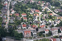
| In front the Rönnebecker Straße from no. 14–26 or 11–19, left the street Lose Barg | |
| Basic data | |
| city | Bremen |
| district | Blumenthal |
| Cross streets | Jollenstrasse, Fresenbergstrasse, Gang, Lose Barg, Kalfaterstrasse , Kreinsloger , Galgenberg, Helgenstrasse, Wietingsgang, Hinrich-Dewers -Str. |
| use | |
| User groups | Cars, bikes and pedestrians |
| Road design | two lane road |
| Technical specifications | |
| Street length | 1100 meters |
The Rönnebecker Straße is a central access road in Bremen , Blumenthal district, Blumenthal and Rönnebeck districts . It leads in an east-west direction from Kapitän-Dallmann-Strasse and Weserstrandstrasse to Dillener Strasse.
The cross streets and connecting streets were u. a. Named as Weserstrandstraße , Kapitän-Dallmann-Straße after the polar explorer Eduard Dallmann (1830-1896), Jollenstraße after the sword boats built there , Fresenbergstraße after a Frisian family who lived there, passage as a narrow connecting path, Lose Barg (Low German) after a loose mountain , Kalfaterstraße after sealing the boat planks with oakum or cotton and wood tar and pitch , Kreinsloger to the camp (= Loger ) of crows gallows after the execution site, which was last used in 1900, Helge road after the shipbuilding place in the yard, unnamed street, Wietingsgang after the captain's family ( Heinrich Wieting , Louis Wieting * 1819 , Louis Wieting * 1850 ), Cord Wieting, Hinrich-Dewers- Strasse after the entrepreneur and mayor of Rönnebeck (1856-1941) and Dillener Strasse after the name Auf dem Düllen mentioned in 1586 for Neu Rönnebeck; otherwise see the link to the streets.
history
Surname
The Rönnebecker Straße was named after the district in Blumenthal. The name Auf dem Ronnebeeke for settlement on the Bachrinne was first mentioned in 1586.
development
The road is an old connection from Blumenthal to and in Rönnebeck.
Blumenthal is Bremen's northernmost district.
Rönnebeck ( Ronnebeeke = settlement on the brook channel) was first mentioned in 1586 and was for a long time at the office or district of Blumenthal. In 1908 the place was incorporated into Blumenthal.
traffic
From the Kreinsloger the street is the federal highway 74 . In 2009 the extension of the federal highway 74 to the A270 highway took place parallel to the street .
The regional S-Bahn Bremen / Lower Saxony with the RS1 line has been crossing the street since 2011 and has the stop at the nearby Kreinsloger.
In local transport in Bremen, the road runs through bus lines 90 (Gröpelingen ↔ Neuenkirchen) and bus lines 91 ( Gröpelingen ↔ Rönnebeck) and 92 (Gröpelingen ↔ Rönnebeck) to Kreinsloger .
Buildings and facilities
On the street there are mostly one- to two-storey houses as well as three to four storeys. Houses.
- Kapitän-Dallmann-Strasse 84: 1-gesch. House of Captain Dallmann from around 1850.
Notable buildings and facilities
- No. 1 to 7: 4-st. Residential and commercial building from around 2000 with clinker-clad basement and distinctive curves and a somewhat maritime look
- No. 9: 1-sch. Plastered gable-independent residential and commercial building from around 1910/20
- No. 10: 2-sch. Plastered gable-independent residential house from around 1910/20
- No. 11: 4-sch. brick-built residential and commercial building from around 1910/20 with two bay windows and the headquarters of the Bremen-Stedingen ferries (FBS)
- No. 12: 1-sch. Rönnebeck community center
- No. 14: 1-sch. Plastered house with side gable building in Baroque style with a central risalit
- No. 17: 1-sch. House with gable from around 1910/2
- No. 18: 1-sch. Plastered gable-independent residential house from around 1910/20
- No. 28: 1-sch. plastered house from around 1910/20 with 2-storied. Central projection and bay window
- Between No. 19 to No. 29: Green zone
- No. 39: 1-sch. Gabled house with half-timbering and thatched roof as a crooked hip
- Helgenstrasse / Kalfaterstrasse / Galgenstrasse:
- Primary school Rönnebeck with 2-tier. Location with 5 classes (2018)
- The after-school care center of the Bremen-Nord district school association based in Helgenstrasse
- No. 56: 1-sch. plastered house with gable
- No. 64: 2-sch. Newer residential and commercial building with Deutsche Post branch and Postbank
- No. 68/74: 1-cut. newer mall
- No. 94: 1-sch. Plastered gable-independent house with a crooked hip roof
- No. 96: 3-sch. Newer residential and commercial building with the Sparkasse Bremen - branch Rönnebeck and behind it the Rönnebeck pharmacy
- Wietinggang: access to Dillener Park and the banks of the Weser
See also
literature
- Monika Porsch: Bremer Straßenlexikon , complete edition. Schünemann, Bremen 2003, ISBN 3-7961-1850-X .
Individual evidence
- ↑ Hanswilhelm Haefs: Settlement names and local history from Bremen: Notes on the history of the port city and federal state as well as the archbishopric including the Holler colonies. Book on Demand, 2006, p. 51. Neurönnebeck was called Auf der Düllen until around 1850
- ↑ Monument database of the LfD Bremen
Coordinates: 53 ° 11 ′ 10.5 ″ N , 8 ° 33 ′ 17.6 ″ E

