
Bremen market square
| Marketplace (as a place of social life) At the market (as a postal address) "good room" |
|
|---|---|
|
|
|
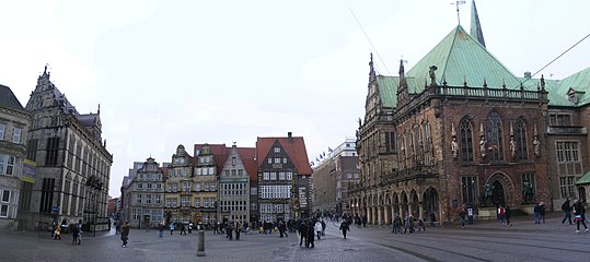
 The Bremen market square viewed from the western corner with a view of the town hall, the Bremen cathedral and the House of Citizenship |
|
| Basic data | |
| city | Bremen |
| district | Bremen-center |
| Created | 1200-1300 |
| Newly designed | around 1863, 2002 |
| Confluent streets | Our Dear Women Churchyard , Am Dom, Dieter-Klink-Platz, Marktstrasse, Wachtstrasse, Schüttingstrasse, Langenstrasse , Obernstrasse |
| Buildings | Bremen Town Hall , House of Citizenship , Schütting |
| use | |
| User groups | Pedestrian traffic , tram (transit), bicycle traffic (limited), venue |
| Space design | Bremer Roland , Bremer Loch |
 Market between town hall , Schütting and citizenship |
|
The Bremen market square is located in the center of the Hanseatic city and is one of the oldest public squares in Bremen . Nowadays, there is no longer a market on the 3,484 square meter open space into which five streets flow and to which two other squares adjoin. Exceptions are the Bremen Christmas Market and the Small Freimarkt . Locals also refer to the marketplace as the city's “parlor”. When mailing address is his name on the market . The Weserweg , a 193 kilometer long long- distance hiking trail that leads from Porta Westfalica along the Weser, ends at Bremen's market square .
location
The Bremen market square is located in the eastern part of the old town on the right side of the Weser and is oriented northwest-southeast. Langenstrasse and Stintbrücke flow into its western corner , and Obernstrasse and Liebfrauenkirchhof join at its northern end . In the east the square borders on the grass market and in the south on the street “Am Markt”. The marketplace has the shape of a slightly indented trapezoid . The northeast side is 60 meters long, the southeast side measures a good 54 meters, the northwest side about 51 and the southwest side 74 meters.
The entire market square, like some of the adjoining streets, is a pedestrian zone . From the Grasmarkt, however, tram tracks for lines 2 and 3 run along the northwest side of the square between the town hall and Roland to Obernstraße.
History and Development
Beginnings
While in the 1950s it was assumed that prior to the construction of the town hall only the St. Vitus, today Liebfrauenkirche, which was probably founded by Bishop Willerich in the early 9th century , is based on archaeological investigations carried out since the 1970s today it is assumed that market areas first developed simultaneously on the banks of the Balge and on the dune ridge.
The area bordering the Balge had a different shape in the course of the arm of the Weser: In the western part it rose significantly, there the Langenstrasse was created with Schiffsländen on the south side and houses of the traders on the dune slope. In the lower part of today's market square, the area was flat, unsuitable for building permanent houses, but well suited for temporary market stalls. The southern corner served as a fish market, as extensive rubbish finds show. In the upper part of today's square, the terrain rose more steeply than today.
The square, known today as Our Lady Churchyard , by the St. Vitus Church or Church of Our Lady, which was also known as the Market Church, was probably the main site of the annual free market until the 19th century from the market privilege of King Arnulf of Carinthia . The market area by the church was, however, in competition with its cemetery until the 13th century.
Plaza

In the Chronicle of Adam of Bremen , the large gate ("porta grandis") of the Domburg against the market ("contra forum") is mentioned, which was built around 1030, but was torn down again a little later to cover the stones for the new construction of the cathedral use. Remnants of pavement from the street leading through the gate were found in 2002, north in front of the foundations of the Balleerhaus , opposite the south-easternmost arches of the town hall arcade. Both together suggest that "forum" referred to today's marketplace as early as the 11th century.
At that time, its eastern boundary formed the outer edge of the 12 m wide moat that was filled in when the wall was built. Traces of a wooden cellar from the 12th century found under the basement of the Balleerhaus in 2002 show that building on the area of the fortification ring had already begun a hundred years after the great gate. The houses demolished in 1860 for the construction of the stock exchange were only built in the middle of the 15th century (Balleerhaus) and later, but the building line of their market gable almost followed the outside of the ditch of the Domburg.
For the western edge of the market square there is the theory that it extended to today's Hakenstrasse, which would amount to a contiguous area from St. Vitus Church to Belge. However, the archaeological find of a fireplace indicates that the construction of the strip between Hakenstrasse and today's edge of the square began as early as the 9th century.
Since the late 12th century, the lower end of the square has been raised a little in several steps, creating an even gradient overall. For this purpose, mainly mud from the bellows was used, which they tried to keep navigable in this way. As early as the end of the 13th century, a hundred years before the construction of today's town hall , today's floor relief was made and the entire square was paved with stones.

1589: Marktplatz (from the topographically imprecise, colored copper engraving by Frans Hogenberg )
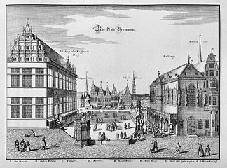
M. Merian the Elder Ä. : 1630: Market place from the southeast. Left Schütting , right town hall , market wall with pillory (fictional viewer position, see floor plan from 1796)
Bremen market from the southeast - montage of photos with Merian's possible viewing directions
-Braun-Hogenberg.png)
.jpg)

Market at the town hall
At about the same time as the town hall was being built, the Roland statue on the market square was renewed . In the following years, a 110 to 120 centimeter high stone wall was built, which divided the square into an inner area and an outer ring. The market was held in the inner area and there was a regulation that only traders were allowed to participate, whose cars could fit through one of the seven passages in the enclosure. With this decision, the city council wanted to offer market customers more space to walk around between the individual stalls, as it was often too crowded before.
At the beginning of the 19th century, the wall was dismantled and replaced with individual stone pillars that formed a circle. At that time, the square had long since lost its outstanding economic importance as a trading and transshipment point for Bremen, although market for local consumption was held there until the 1930s. Sandstone slabs were laid on the square in 1863. The inside of the circle of columns showed a ten-spoke wheel made of darker stones, the center of which formed a Hanseatic cross ( paw cross ) formed with reddish stone . The cross, which has a diameter of 4.8 meters, should remind of the importance of the Hanseatic Legion during the era of the Wars of Liberation . The paving of the Bremen market square was renewed from February to June 2002. The redesigned historic Bremen market square was then opened to the public on October 10th with an opening party.
Excavations

During these renovations, archaeological finds from the 6th to 18th centuries were found in various places. Although the building authorities did not allow extensive excavations, selective investigations could be carried out. The excavations were carried out by the state archaeologist . In the course of the excavations, among other things, the remains of the walling and market gate of the early medieval cathedral castle were found and the foundation walls of those houses were documented that marked the east side of the market square when the stock exchange was built. Furthermore, 5,719 bones and pieces of bones were recovered from humans as well as from domestic animals and birds. Ceramic fragments and other everyday objects such as bone needles, bone cubes, vessels and coins were also recovered.
After the archaeological work was completed, glass plates were set into the edges of the pits at ground level for a few weeks so that passers-by had the opportunity to take a look at the sites. In the summer of 2002, these plates sparked a public discussion, in which there was a dispute as to whether the “peepholes” should be permanent or whether they should be removed after the renovation of the market square. Ultimately, the decision was made to refill the pits. Today nothing can be seen of them.
Jurisdiction and criminal justice

Since the beginning of its existence, the marketplace has also been a place of jurisdiction and the execution of sentences.
When the town hall was built in 1405, the mayor's court had to be relocated to another location, as the previous one was being built over. The decision was made for the area under the second arch of the town hall from the west. Unlike the city council court, this met publicly. In addition, he also included civil assessors. With the move, however, the court lost its importance vis-à-vis the council court. Property and entitlement conflicts were primarily negotiated on the three annual negotiation days. In addition, the mayor had to confirm the judgments of the council court. With the dissolution of the city bailiwick in 1802, the court ceased to exist.
With a pillory (the so-called Kaak ) and a disgrace , the external signs of jurisdiction were also on the market square. The pillory was erected in the 16th century, had an octagonal shape and was integrated into the market wall on the east side of the square. Inside the small building, a narrow spiral staircase led to the upper platform on which the stake stood. The condemned were tied to these and whipped. However, depending on the type of crime, all they had to do was endure public disgrace . The Kaak was demolished in 1786 because it was dilapidated.
Presumably before the Kaak the disgrace was set up on the square. Its location was close to that of the pillory, but outside the market wall. The disgraceful donkey was a wooden frame with four legs on which a body in the shape of a donkey was mounted. The delinquents were put on him and sometimes tied up. But there was no flogging on the disgrace. As the name suggests, it served to emphasize the shame of crime. It was removed between 1734 and 1738.
Development
The ensemble of buildings that frames Bremen's market square is one of the most beautiful in Germany. With the Roland statue and the town hall, part of it was added to the UNESCO World Heritage list in July 2004 . The design of the market is quite uniformly characterized by the materials sandstone (including Schütting) and dark brick or clinker (including town hall, citizenship).
Northeast side
The Bremen Town Hall is located on the northeast side of the square . This was built in the years 1405 to 1410 in the Gothic style. The building was given its present form between 1608 and 1612 under the direction of the architect Lüder von Bentheim . He renewed the entire market square facade and designed it in the style of the Weser Renaissance .
Southeast side

At the end of the 15th century, elaborately designed gabled houses were built on this side of the market square and on the adjacent grass market in front of the Bremen Cathedral , some of which lasted for up to 400 years. The Balleersche Haus , Markt 26 / corner Heu- or Grasmarkt, with a Gothic , six-axis brick gable , dates from the 15th century. Next to it, the Pundsack House from the Renaissance , Markt 25, a magnificent, six-axis gabled house with pillar templates, was built around 1570 and received a Baroque portal and two single-storey lofts around 1770 . This was followed by five more gabled houses, mostly in the baroque style. The gabled houses were demolished in the course of the construction of the New Bremen Stock Exchange from 1860 to 1863 and the building line moved back about ten meters. The newly created neo-Gothic building was inaugurated in 1864 and, from an architectural point of view, was part of a well-designed building in Bremen at the time, but was felt by large parts of the population to be too bulky and unsuitable at this point.
The stock exchange was completely destroyed on December 20, 1943 in an Allied air raid during the Second World War. The ruin remained standing for a long time and was only demolished after the Chamber of Commerce sold the site to the city in 1957. The Chamber of Commerce had previously announced an ideas competition for the development of the property in 1951/1952, in which 128 architects took part. However, the ideas were not pursued any further. By 1956, the Chamber of Commerce built Börsenhof C , a six-storey office and commercial building based on plans by Bernhard Wessel, on the property .
In 1958, the city announced an architectural competition for a new seat for the Bremen citizenship on the property, in which 71 designs were submitted. A decision was made on two drafts, but they should be revised. A controversial discussion about the design of the building flared up in public; and so in 1961 a new competition was announced, which Wassili Luckhardt won. His revised plans envisaged a vertical stone and glass structure of the facade with eight indicated gables on the roof. Although this design also seemed too modern for the marketplace for many of Bremen's citizens, it was implemented and the new Citizens' House opened in 1966 .
Southwest side
-2011-03_(retuschiert).jpg)
No. 13: Der Schütting , seat of the Bremen Chamber of Commerce . In 1444, the Bremen merchants bought a house on the southwest side of the market square. They had this torn down in 1535. In just two years, from 1537 to 1538, a building similar to the strict, delicate renaissance buildings in Flanders, the Schütting, was built. The merchants had deliberately had it built directly opposite the town hall to demonstrate their power as a group, although more and more councilors came from their ranks anyway. The inscription in the magnificent portal from 1899 buten un inside - dare un winnen (“outside and inside - dare and win”) has meanwhile developed into a kind of Bremen city motto. The Schütting was the seat of the parents in Bremen , later also called Collegium Seniorum , and since 1849 the Bremen Chamber of Commerce. The building burned down completely after an air raid on October 6, 1944, but was able to be rebuilt in its old form by 1956.
No. 14, 15, 16: Bankhaus Neelmeyer . The building ensemble originally consisted of: House no. 14: The Bremische Hypothekenbank , later Neue Sparkasse , was built in 1895 according to plans by Albert Dunkel . House No. 15: The Lower Saxony Bank . House No. 16: Wilcken's house from around 1650 was the last town house on the market until 1893. Instead, a new building for the Lower Saxony Bank was built according to plans by Fritz Dunkel and Hermann Meyer. Façade elements of Wilcken's house, such as the late Renaissance gable, were reused. The independent buildings nos. 15 and 16 were combined into a restaurant and office building in 1912 through the renovation according to plans by the architect Rudolf Jacobs . After the war destruction, the gables were not restored between 1948 and 1950. The reconstruction was carried out according to plans by the architect Herbert Anker . Only one Auslucht (Utlucht) of Wilcken's house remained. Bankhaus Neelmeyer has owned building no.14 since 1927 and the bank has had its headquarters at no.14 to 16 since 1954.
No.17: In 1950 the medical department store was built according to plans by Fritz Brandt.
No. 18/19: Eduscho House , Bankhaus Carl F. Plump & Co. House No. 18: The commercial building was built as Eduscho House from 1952/1953 according to plans by Arthur Bothe . House No. 19: The corner house was built in 1960 based on plans by Gerhard Müller-Menckens . The sculptor Renate Albers modeled the coat of arms stones above the door lintel.

South side with Schütting and Bankhaus Neelmeyer , left of it cotton exchange and citizenship

North-west side with gabled houses (right next to the Roland the Rathscafé / Deutsche Haus ), left the Schütting


Northwest side
On the north-west side, a few gabled houses in the Renaissance style were built in the 16th and 17th centuries, none of which has survived. Today's historic-looking facades were built in the 20th century. From right to left are the following listed buildings:
No. 1: On the corner of Am Markt / Obernstrasse is the Rathscafé / Deutsches Haus , built in 1909, partially destroyed in the war and then originally reconstructed, with the inscription Gedenke der Brüder, who bear the fate of our separation , which was added in the 1950s Wilhelm Kaisen's warning about the division of Germany goes back. The building has been owned by the Körber Foundation since 2007 .
No. 9: The gabled house built here in the Renaissance style around 1600 later served as a Consuption House and was destroyed in the Second World War. Including the door portal from 1620 that has been preserved from the old building, the Zum Jonas house was built in 1956 according to plans by Bernhard Wessel , in which restaurants are housed. On the top of the gable there is a sculpture of a whale after which the house was named.
No. 11: In 1594, an ensemble of buildings with two gables for the Raths pharmacy and the excise department was built based on the drawings by Lüder von Bentheim . Its renaissance front was replaced by a Biedermeier facade around 1830. In 1893 the upper floors burned out and the house was given a central gable according to plans by Max Salzmann . This house also fell victim to the bomb attack that destroyed the Schütting. It was rebuilt according to plans by Herbert Anker until 1958 with two gables in the neo- baroque style.
No.12: At the confluence of Langenstrasse and Marktplatz, the building of the Stadtsparkasse was built in 1957/1958 according to plans by Eberhard Gildemeister and with the support of the state monument conservator Rudolf Stein using the original substance of the facade of the destroyed rococo house Schlachte No. 31 .
On the marketplace
During the centuries of its existence, there was only one solid building within the market wall: the market guard. It was built before 1756 and had an octagonal shape and a baroque dome with a lantern on top. The market guard , which was not far from the pillory, served as Bremen's main guard during the Seven Years' War . The guard was torn down around 1810.
Space design
In addition to the aforementioned Hanseatic Cross as the city's most distinctive ground symbol and the dominating Roland statue, you will also find smaller features and various sights on the square that do not immediately catch your eye.
Bremen Roland
The Bremen Roland is located directly on the market square, slightly to the left, six meters in front of the facade of the town hall. The first wooden Roland was burned by the archbishop's henchmen in 1366. The current one dates back to 1404 (the year the market square was built and the renovation of the town hall began). It is a symbol of the freedom of Bremen and therefore, as the legend has it, looks in the direction of the cathedral portal to remind the clergy of the power of the city council. The limestone figure is more than five meters high. The distance between the knees is one cubit from Bremen (exactly 55.372 centimeters) and a cripple, who is one of the protagonists of the legend about Emma von Lesum, is incorporated at her feet .
Founding legend
Since 1612, a small stone hen on a nest with chicks has been placed in the right gusset of the second arch from the left of the town hall arcade facing the square. This hen is part of one of the most famous legends of the Hanseatic city, the " Legend of the Bremer Gluckhenne ". Legend has it that Weser fishermen had to seek shelter from a storm and saw a hen with her chicks, who went to safety on a dune. They saw this as a sign of their nature gods and also set up their camp at this point - the beginning of the city of Bremen.
Bremer Loch


Since 2007 there has been an underground donation box called the “Bremer Loch” on the cathedral-side corner of the citizenship building, which is embedded in the pavement of the market square. It addresses the “secret landmark” of Bremen, the Bremen Town Musicians , by reproducing the sounds of animals when a coin is inserted. The initiator of the donation box and also the beneficiary of the donations is the Bremer Wilhelm-Kaisen-Bürgerhilfe , which, as an umbrella organization of welfare organizations and under the chairmanship of the respective mayor, organizes collections.
The circular lid of the donation can is similar to a manhole cover. It is made of bronze and has a diameter of 45 centimeters. The donation can is secured against theft with a special device and is 90 centimeters deep. The lid bears the lettering "Wilhelm Kaisen Bürgerhilfe der Free Hansestadt Bremen" all around the edge in capital letters. In the middle of the lid there is a slot for money and a Low German inscription that alludes to the sounds of the Bremen town musicians - rooster, cat, dog and donkey: "Don't row, don't yelp, don't growl, segg i-aa, doh wat in 't Bremer Loch ”(“ Don't crow, don't yelp, don't growl, say yes, do something to the Bremer Loch ”). When coins are inserted into the donation slot on the lid, it reproduces the sounds of the four Bremen Town Musicians ( - - - ). The animal sounds were recorded by Radio Bremen in the summer of 2007 and are now triggered by a photo cell .
The Bremen design studio Haase & Knels designed this “acoustic social money box”. With the donations - up to 15,000 euros per year - Wilhelm-Kaisen-Bürgerhilfe supports selected projects. The “Bremer Loch” was inaugurated on July 27, 2007 in the presence of Christian Weber , President of the City Council , who was also chairman of the foundation.
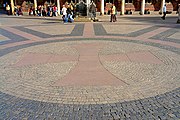
The Hanseatic Cross on the market square, in front of the Roland
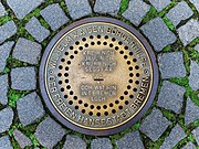
The "Bremer Loch" near the House of Citizenship - a donation plate


Events


In addition to the normal weekly market, the marketplace was also repeatedly the venue for festivals and demonstrations. In the 19th century the square was a place for national festivals (Schillerfeier) and marches (commemoration of the victory over Napoleon in 1813). On November 15, 1918, the workers 'and soldiers' council announced to a large crowd from the balcony of the town hall that it was taking over political power in Bremen and hoisted the red flag. From the beginning of the 15th century until 1919, the square was one of several locations on the Bremen Freimarkt . Nowadays, the nostalgic Kleine Freimarkt takes place there at the same time as the big model on the Bürgerweide . Towards the end of each year, from the last days of November to Christmas Eve , the main part of the Bremen Christmas market is set up on the market square and the surrounding squares . More recently, for example, the wine festival, the day of coffee and the children's festival “SpielRäume create” have been organized on the square .
Another traditional event is the Turmbläser in Bremen on the viewing platform of the south tower of Bremen Cathedral. The tower blowers have existed in Bremen since at least 1737. They blow chorales, quartets, fugues and folk songs with trumpets every Sunday after the service . During the Christmas season, they not only play on Sundays, but more often. The tradition of the tower blowers threatened to go under in Bremen just a few years ago because the financing was unsecured, but since about 2006 the concerts have been taking place regularly again.
In addition, the SV Werder Bremen's victory celebrations are held on the market square if they win the DFB Cup or the German football championship . When they won a double in the 2003/04 season , over 40,000 fans celebrated the team that presented themselves on the town hall balcony.
Every year (one week before the Rhenish Carnival) the opening staging of the street parade of the Bremen Samba Carnival takes place on the market square . From here, Europe's largest samba carnival with masks and rhythms moves towards the district .
Since August 16, 2004, a Monday demonstration has been taking place on the square every week . Its criticism is based on current political issues. The initiative of the Vigil for Peace, which is held on Thursdays between 5 and 6 p.m., has existed since 1982 . Since February 26, 2017, the market square in front of the House of Citizenship has been a Sunday demonstration location for the pro-European initiative " Pulse of Europe ".
Surroundings
Many historical and touristic sights are grouped around the market square. A selection is named and briefly presented below:
Streets and squares
- The Böttcherstrasse is the most famous street in the city. A narrow southern entrance, the Schüttingstrasse, leads past the Schütting to the famous street, which is only 100 meters long and is artistically designed throughout. The sculptor Bernhard Hoetger was responsible for this between 1922 and 1931 . His work was financed by the Bremen coffee merchant Ludwig Roselius , who at that time owned the entire street. It has been a listed building since 1937 and is now home to arts and crafts workshops, museums and exhibitions.
- At the end of the alley, a tunnel leads past the medieval Martinikirche to the banks of the Weser and Schlachte .
- The historic Langenstrasse leads between Schütting and Stadtsparkasse past the Weser Renaissance buildings , the Stadtwaage and the Essighaus , west to the Stephaniviertel.
- The main road that leads to the west, is one of the main shopping streets of the city.
- As a shopping street, Sögestraße leads north to the Wall with the ramparts and to Bremen Central Station .
- The Unser-Lieben-Frauen-Kirchhof square with the Gothic Church of Our Lady connects directly to the market square. The flower market is here on weekdays.
- During the week there is a market on the Domshof to the north, which is surrounded by banks .
- The eastern Domsheide is an important traffic junction in the local public transport network.
Monuments

- The heralds stand on both sides of the east portal of the town hall on the grass market in close proximity to the market square. The sheet copper figures that were designed by Rudolf Maison in 1901 have only been in this place since 2001, after they were moved to another location after the Second World War.
- The Bismarck monument by Adolf von Hildebrand , an equestrian monument made of bronze on a high stone base, unveiled in 1910 in memory of Reich Chancellor Otto von Bismarck , stands at a happily chosen hinge position between the market square and the cathedral courtyard.
- The spitting stone is an inconspicuous basalt stone with a notched cross, set into the pavement, near the Bismarck monument and about 20 meters north of the bridal portal of the cathedral. The scaffold on which the poisoner Gesche Gottfried was beheaded in the last public execution in Bremen in 1831 is said to have stood at this point . Even today some people from Bremen and tourists express their disgust for these murders by spitting them out on this stone.
- To the north of the cathedral in Sandstrasse are the Heineken house with the oldest painted wooden ceiling in Bremen (1580) and the Vorwärts house with its remarkable facade. It belonged to the “Vorwärts” association for over 120 years and parts of it date from the end of the 15th century.
- The Bremen Town Musicians , which are one of the most popular photo motifs in the city today, are a bronze sculpture created in 1953 by the sculptor Gerhard Marcks . The animals are located on the west side of the town hall at the entrance to the street Schoppensteel. Many people believe that if you grasp or rub the donkey's front legs and make a wish, a wish will come true. At this point the statue is therefore shiny.
- The Citizenship Sculpture Garden is right next to the Citizenship House. It contains six sculptures (1960 to 1969) by Gerhard Marcks .
- The oldest wine cellar in Germany, the Bremer Ratskeller, is also located in the town hall . The cellar system, which consists of eight rooms, can be reached via a staircase that leads down on the northwest side of the town hall. Over 650 different wines are stored in the Ratskeller, as well as the oldest barrel wine in Germany. The premises were created around 1404, when the city council moved its white wine bar to the cellar of the old town hall. Over time, they have been continuously expanded. Nowadays the Ratskeller houses a traditional inn and a gourmet restaurant.

Fountain in the area
- The Neptune Fountain by the sculptor Waldemar Otto was built in 1991 on the nearby Domshof .
- The Marcus fountain from 1909 on the Liebfrauenkirchhof was also previously known as the taxi fountain .
- The horse fountain from 1974 by sculptor Manfred Lohr angel , with three different levels of reservoirs (dogs, horses, birds), stands at the confluence Oberstraße corner Sögestraße .
- The tower blower fountain (Bremen) from 1899 with a bronze group of sculptures by Max Dennert on the southwest corner of the cathedral.
Monument protection
The entire facility and all buildings on the market square are under monument protection :
- Am Markt 1: Rathscafé / Deutsches Haus , 1908–1911
- At market 9: House Jonas and Kaune, 1600 and 1955
- Am Markt 11: Raths-Apotheke , 1893/1894 and 1957/1958
- Am Markt 12: Sparkasse am Markt , 1755 and 1958
- Am Markt 13: Der Schütting , 1537/1538
- At Markt 14, 15 and 16: Bankhaus Neelmeyer , Wilckens'sches Haus, Bremische Hypothekenbank, “Zum Roland” office building, Niedersaechsische Bank
- Am Markt 17: Medical department store, 1950
- Am Markt 18: Eduscho-Haus, Carl F. Plump & Co. banking house , 1952/1953
- Am Markt 19: Bankhaus Plump & Co., 1960
- Am Markt 20: House of the Citizens , 1962–1966
- Am Markt 21: Town Hall , Bremer Ratskeller , New Town Hall , from 1400 until today
- Marktstrasse 3: House C of the Chamber of Commerce, 1956
- Am Dom 1: St. Petri Cathedral , from 1041 until today
- Am Dom 2: Kuesterhaus, 1926–1928
- Boettcherstraße 1, 2, 3, 4, 5, 6, 7, 8 and 9: 1922-1931
- Langenstrasse 2, 4, 6 and 8: ex Disconto-Bank , today an office building on the market with a shopping mall, 1910–1912 and 2001/2002
Individual evidence
- ↑ Manfred Rech (Ed.): Found Past - Archeology of the Middle Ages in Bremen , pp. 69–75, Bremer Archäologische Blätter, Vol. 3, 2004, ISBN 3-7749-3233-6 .
- ↑ Dieter Bischop : The Bremer Balge in the early Middle Ages (2011) - In: Rivers as communication and trade routes. March Council Colloquium 2009, pp. 359–378.
- ↑ Dieter Bischop: Paved with bones: The archaeological observations and excavations at the historic Bremen market. (2006) - In: Journal of Archeology of the Middle Ages vol. 34 (2006) pp. 215-230.
- ^ Dieter Bischop: On the edge of the Domburg. Preliminary report on the 2002 excavation on the historic market square of Bremen (2005) - In: Festschrift Torsten Capelle pp. 9–24.
- ^ Information brochure from the Focke Museum from 2006, p. 7.
- ↑ Nicolaus Roller: Attempting a History of the Imperial and Reichsfreyen City of Bremen (1799) Part 1, III.III.Ba1. The market (p. 33 ff.) P. 34 : "The meat and fish market is all around as a large square with a wall about 4 feet high ..."
- ↑ Bremen market square in new splendor. Senate Press Office, October 10, 2002, accessed October 4, 2010 .
- ↑ Hans Christian Küchelmann: Paved with bones. (PDF; 1.1 MB) (No longer available online.) Knochenarbeit.de, January 23, 2007, archived from the original on September 20, 2007 ; Retrieved October 4, 2010 . Info: The archive link was inserted automatically and has not yet been checked. Please check the original and archive link according to the instructions and then remove this notice.
- ↑ a b Konrad Elmshäuser : The bailiwick and criminal justice. In: Konrad Elmshäuser / Adolf E. Hofmeister (eds.), 700 Years of Bremen Law, Publications of the Bremen State Archives Vol. 66, self-published by the Bremen State Archives, 2003, ISBN 3-925729-34-8 , p. 212 ff.
- ^ Herbert Black Forest: The Great Bremen Lexicon. 2nd, updated, revised and expanded edition. Edition Temmen, Bremen 2003, ISBN 3-86108-693-X , p. 759.
- ^ Rudolf Stein: The community center in Bremen . Wasmuth-Verlag, Tübingen 1970.
- ^ Herbert Black Forest: The Great Bremen Lexicon. 2nd, updated, revised and expanded edition. Edition Temmen, Bremen 2003, ISBN 3-86108-693-X , p. 571.
- ↑ a b (ap): Germany's first underground donation box. In: rp-online.de . July 27, 2007, accessed May 23, 2018 .
- ↑ Communication in space. (No longer available online.) Haase & Knels - Atelier für Gestaltung, archived from the original on April 12, 2010 ; Retrieved October 4, 2010 . Info: The archive link was inserted automatically and has not yet been checked. Please check the original and archive link according to the instructions and then remove this notice.
- ↑ Böhnke is the keeper of the underground safe. Weser-Kurier , May 23, 2015, accessed on May 23, 2015 .
- ^ Photo series to celebrate October 18, 1863, in: Harald Goergens and Alfred Löhr: Bilder für alle, Bremen 1985, p. 77.
- ^ Monument database of the LfD
literature
- Regina Bruss (Ed.): Bremen, Bremerhaven. Story + stories . Eilers + Schünemann publishing house, Bremen 1980.
- Herbert Schwarzwälder : Bremen through the ages. Volume: The old town. Carl Schünemann Verlag, Bremen 1985, ISBN 3-7961-1662-0 .
- Herbert Schwarzwälder: Greetings from Bremen. The old town on early postcards. Edition Temmen , Bremen 1998, ISBN 3-86108-611-5 .
- Herbert Black Forest: The Great Bremen Lexicon . 2nd, updated, revised and expanded edition. Edition Temmen, Bremen 2003, ISBN 3-86108-693-X .
Web links
- “Paved with bones. Bone finds from the market square in Bremen " - Scientific treatise on the archaeological excavations (PDF; 1.03 MB)
- Interactive 360 ° panorama of the market square, can be moved in any direction with the mouse
Coordinates: 53 ° 4 ′ 32 " N , 8 ° 48 ′ 25" E