
Grasmarkt (Bremen)

"Grasmarkt" is the historical name for the town square between Bremen's market square and Bremen's St. Petri Cathedral . Today it is officially part of the street Am Dom .
location


Construction lines and culverts were clockwise at the beginning of the 19th century:
- northeast of the south gable of the archbishop's palatium
- to the east the broad connection to the Domshof
- southeast the tower front of the cathedral
- south the connecting road to Domsheide
- to the south-west the north-east sides (main gable) of the houses surrounding the Wilhadikapelle , interrupted by a connecting lane to the sausage market in front of this church
- to the west the broad connection to the market square
- northwest of the narrow side of the town hall including its extension with the second whiteness room "Nye Dornßen"
- north of the narrow passage between this and the Maria Magdalenen chapel of the palatium.
history
In the 11th century, the area of the square lay entirely within the Domburg and was connected to the market outside its wall ring by a large gate ( Adam von Bremen : "porta grandis contra forum"). In the middle of the century, Archbishop Adalbert had the gate tower, which was only about ten years old, and large parts of the fortification walls removed in order to use the stones to complete the cathedral more quickly.
The boundaries of the building were gradually built: the west crypt, consecrated in 1066, did not initially have its most western vaulted yoke . It was only under the episcopate of Gerhard II (1219–1258) that the west facade came to its present location with the construction of the towers. The palatium was built from 1293 and the town hall from 1405.
Up until the 19th century, hay was actually sold on the square for the numerous draft animals and other farm animals kept in the city. An exception to this was an area around 15 m wide in front of the cathedral, separated by a wall and called the Kleiner Domshof .
This demarcation was abolished in 1809 after the cathedral and the other former archiepiscopal properties became part of the city of Bremen in 1803. In 1818/19 the palatium was converted into a classicist town house after more or less extensive demolition .
The small district, also known as the Willehadiblock , consisting of the Willehadikirche and the surrounding streets and houses, was demolished in 1861 and replaced by the New Stock Exchange by 1864 . In this context, the old use of the square ended and in 1864 the corresponding street name also disappeared. While the building boundaries of the Willehadiblock with the corner of the Balleerhaus protruded to the long side of the town hall, the corner of the Neue Börse was a continuation of the narrow side of the town hall, so that the spatial demarcation between the market and the grass market has been clearer since then than when it was bore his name.
Since November 3, 1879, trams have been running across Grasmarkt, initially parallel to the Weser, and from 1883 to 1987 also in the direction of Domshof. Donated by private hands, the Wilhadibrunnen had stood in the middle of the square since 1883, but the fountain figure was melted down during World War II and the basin was removed again in 1952.
After the destruction of the stock exchange building in the Second World War and fierce controversy about the further use of the property, the House of the Citizens was built there from 1961 , which was inaugurated in 1966. Around that time, the grass market became a pedestrian zone, through which trams and buses continued to roll in several directions. Since 1987 there has only been a pair of tracks with two tram lines that do not push pedestrian traffic to the edge. Cycle traffic between Domshof and Balgebrückstraße is still permitted, for about two years at night and on weekends also from and towards Obernstraße
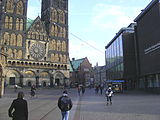
Cathedral , House of Citizenship , view of the bell

View from the Rathauswinkel to the cathedral and the Domsheide
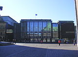
Cathedral steps, citizenship, mirrored the New Town Hall

View between the citizenry and the cathedral to the town hall


Literature and Sources
- Manfred Rech (Ed.), Found Past - Archeology of the Middle Ages in Bremen , pp. 38–50, Bremer Archäologische Blätter, Vol. 3, 2004, ISBN 3-7749-3233-6
- Dieter Bischop , On the edge of the Domburg. Preliminary report on the 2002 excavation on the historic market square in Bremen (2005) - In: FS Torsten Capelle pp. 9–24
- Herbert Schwarzwälder : Bremen through the ages. Volume: The old town. Carl Schünemann Verlag, Bremen 1985, ISBN 3-7961-1662-0 .
- Herbert Black Forest : The Great Bremen Lexicon . 2nd, updated, revised and expanded edition. Edition Temmen, Bremen 2003, ISBN 3-86108-693-X , from it several articles
Coordinates: 53 ° 4 ′ 32.22 " N , 8 ° 48 ′ 27.16" E