
Bellows (arm of the Weser)
.jpg)
The Balge or Große Balge (formerly also called Balje ) was a short, right branch of the Weser , which ran in the area of what is now Bremen's old town . It served as the city's first port in the early Middle Ages and is therefore of great importance for the emergence and development of Bremen. The bed of the bellows gradually narrowed until it was channeled in 1608 and finally completely filled in in 1838.
The bellows in the early Middle Ages
At the time the diocese was founded in the 8th and 9th centuries, the Weser lowlands near Bremen still have to be imagined as a marshy river splitting area with countless watercourses and islands. During construction work on the corner of Martini- / Wachtstraße in 1988/1989, three small watercourses from around 800 were found on an area of 50 × 40 meters and a river boat from the 9th century was found. Due to sand washings as a result of several floods, as well as increasing settlement activity on the river banks, the character of the river landscape changed significantly from the 9th century onwards and the marshy river marshes and small tributaries gradually disappeared.
The Belge, like the Kleine Weser , was one of those formerly numerous natural tributaries of the Weser - there is, however, no surviving evidence for the thesis that it was once the main bed of the river. The bellows originally left the river bed of the Weser at the level of the Altenwall , flowed in an approximately 650-meter-long arc parallel to the Weser at the foot of the Bremen dune , reached the greatest distance from the main stream at around 200 meters at the height of today's market square , and met itself Enlarging funnel-shaped, at the second battle gate (about at house no. 10/11 on the Schlachte ) back into the Weser. The island between the Balge and the Weser - the Bellow Island - largely corresponded to the later Martini and Tieferviertel . At the time, the bellows were 30 to 50 meters wide.
Bremen's first port
It is no coincidence that the diocese settlement was founded in the 8th century at the point of contact between the two most important landscape features in the area of the Bremen basin: the Weser and the Bremen dune. The former offered access to long-distance trade routes, the latter a flood-proof settlement area with a good defensive position. On the north bank of the Balge, which in the area of the south side of today's market square reached right up to the dunes, Bremen's first harbor was built at that time under the protection of the Domburg , which initially had the shape of a long, unpaved bank harbor. The ship landing sites presumably extended over a length of a few hundred meters at the lower edge of today's market square and along Langenstrasse , one of the oldest streets in Bremen and for centuries the most important merchant street in the city, which was probably created during the settlement of the northern bank of the Balge.
The embankment of the Belge was subsequently reinforced in several steps. During excavations directly in front of the Neelmeyer bank (near the confluence of Böttcherstraße and Marktplatz) in 1970, remains of the walled harbor bank of the Belge, as well as dolphins made of oak piles, which were connected in groups of three with iron rings. Similar finds had been made during earthworks in 1909 at the corner of Marktplatz / Langenstrasse and in 1862 in the area of Schütting and Wachtstrasse. Even older structures were found: a bank fortification made of stakes and wickerwork, which is probably of early medieval origin (up to the 10th century), while the stone constructions probably date from the high or late medieval period (between the 11th and 15th centuries). Century). The marketplace can thus be described as the remainder of the original riverside market, on the southern edge of which ships docked directly.
The bellows in the High and Late Middle Ages
The originally considerable width of the bellows was gradually narrowed over the centuries with the growth of Bremen through the development of the banks. In addition, changes in the flow conditions in the river system of the Weser as well as sediment deposits in the river bed contributed to a continuous narrowing. In the late Middle Ages, the width of the bellows had already decreased to around 20 meters (this was the only way the Schütting could later be built on the former river bed of the bellows).
In the 13th century, when the bellows had largely lost its function as a port for larger ships in favor of the Schlachte on the banks of the Weser, an artificial piercing was made, coming from the wooden gate (today at about 12 Tiefer house ), probably along the Vlotgote (Flutgasse), which no longer existed , met the Balge at the Balgebrücke (today around the house at Balgebrückstrasse No. 22) and from then on divided it into two sections. The aim of the measure was to improve the exchange of water between the Weser and the Balge, as the latter threatened to completely silt up due to debris and silt deposits. While the upper arm of the bellows, which flowed through the Schnoor , was henceforth called the monastery bellows, as it ran through the area of the Johanniskloster , the lower arm was called the large bellows . Soon after the breakthrough, the original tributary of the bellows at Altenwall was closed - presumably to strengthen the fortification of the city, because a passage in the city wall would have been a weak point in an attack. The monastery bellows became a dead tributary, which was also fed by rain and flushing water from the neighboring houses. At that time, however, the Große Belge was still used by watercraft. The Belgeverordnung ( Belgeverordnung) issued by the Bremen Council in 1399 regulated that Eken (flat river barges made of oak wood with a width of around 1.50 meters and a length of 3.50 to 10 meters) not longer than three days and three nights a day Bellows were allowed to lie in order not to obstruct boat traffic.
In 1602 the bellows was closed to shipping, in 1608 it was channeled over a width of 4.60 meters through a border in the bank walls and from then on only used as a sewer. In 1819, the Bremen Senate finally decided to fill the entire length of the bellows and replace it with a 1.20 meter wide underground sewer. However, due to old special rights and competing interests of the Balge residents, this project was not actually carried out until 1838 - with that the Balge finally disappeared from the cityscape of Bremen.
bridges
Several bridges have led over the bellows since the Middle Ages:
- The Great Smelt Bridge (as Pontis Piscium was mentioned in a document from 1261.) It led over the bellows from the southeast corner of the Bremen market square .
- The Kleine Stintbrücke was in the course of Haken- / Bredenstraße.
- The Balgebrücke was in the course of today's Balgebrückstrasse.
- The high bridge crossed the vlootgote on the lower .
- A stone bridge lay in the course of Wachtstrasse.
- A bridge led over the monastery bellows at St. Victors Staven an der Tiefer.
- The Schüttingbrücke ran along the Böttcherstrasse over the Balge.
- Probably the Schlachte must also have been crossed by a bridge at the mouth of the Belge in the area of the 2nd battle gate .
It is very likely that they were drawbridges to allow boats and barges to pass through even when the water level was high.
All bridges existed until the end of the 18th century and were then gradually dismantled when the bellows were thrown.
Memories of the bellows

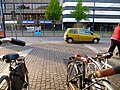
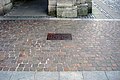
At the suggestion of Senate Councilor Harald Lucht , Head of the Cadastre and Surveying Administration, the former course of the bellows (in its shape as a narrow canal from the 18th century) was built in several places in the old town from 1990/1991 by means of paving and bronze plaques embedded in the floor. Made “visible”, for example on the Schlachte, the Stintbrücke, the Wachtstraße and the Balgebrückstraße, where the fork in Große Balge and Klosterbalge is indicated.
More memories:
- Stintbrücke : leads from the corner of Langenstrasse / Marktplatz past the Schütting to Bredenstrasse
- Balgebrückstraße : leads from Domsheide to Wilhelm-Kaisen-Brücke
- Behind the bellows : the alley that branches off from the Marterburg in the Schnoor
- Bronze sculpture Fietje Balge Behind the Schütting by the sculptor Bernd Altenstein ; Erected in 2007 on behalf of the banking house Carl F. Plump & Co.
- Pavement and bronze plaques to mark the former course of the bellows

Confluence of the bellows and ...
... Klosterbalge on Balgebrückstraße

Balgebrückstrasse (view against the direction of flow)
Smelt Bridge

Slaughter

Bronze plaque bellows

Bronze plaque Klosterbalge
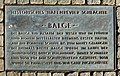
Information board at the Schlachte
.jpg)
.jpg)
.jpg)

.jpg)
.jpg)
.jpg)
New finds
During excavations at Bredenplatz, at the corner of Bredenstrasse and Martinistrasse , which were carried out here at the beginning of 2008 on the occasion of the construction of a new hotel, remnants of the bank fortification of the bellows from around the year 1000 were discovered. It was a construction made of wooden piles, cross planks and Wattle. The excavations also brought to light some individual finds that were once lost in the mud on the banks of the Belge: a Cologne silver denarius , a dagger, a silver fibula and a pair of bone ice skates .
In 2009, during renovation work in the Schifferhaus, the bank reinforcement of the monastery bellows was examined, which, like the large bellows, had recently served as an underground sewer.
Individual evidence
- ↑ Balge or Balje means “watercourse”, “fairway” or “ditch” in Low German .
- ↑ Ulrich Weidinger: With cogs to the market square - Bremen's port structures from the early Middle Ages to the beginning of industrialization . Hauschild Verlag, Bremen 1997, p. 56.
- ↑ D. Ortlam and M. Wesemann: The bellows as the main stream of the Werra / Weser? In: Bremer Archäologische Blätter, NF 2, 1992/93, p. 46 ff.
- ^ Herbert Black Forest: The Great Bremen Lexicon . Edition Temmen, Bremen 2003, p. 60.
- ↑ a b Ulrich Weidinger: With cogs to the market square - Bremen's port structures from the early Middle Ages to the beginning of industrialization . Hauschild Verlag, Bremen 1997, p. 58.
- ↑ Ulrich Weidinger: With cogs to the market square - Bremen's port structures from the early Middle Ages to the beginning of industrialization . Hauschild Verlag, Bremen 1997, pp. 110–117.
- ↑ Ulrich Weidinger: With cogs to the market square - Bremen's port structures from the early Middle Ages to the beginning of industrialization . Hauschild Verlag, Bremen 1997, pp. 49-53.
- ↑ Karl Dillschneider: The Schnoor . Verlag H. M. Hauschild, Bremen 1992, p. 63
- ↑ Karl Dillschneider: The Schnoor . Verlag H. M. Hauschild, Bremen 1992, p. 65
- ^ Friedrich Prüser : The bellows - Bremen's medieval port . Max Schmidt-Römhild Verlag, Lübeck 1953, p. 481.
- ^ Friedrich Prüser: The bellows - Bremen's medieval port . Verlag Max Schmidt-Römhild, Lübeck 1953, p. 483.
- ^ Herbert Black Forest: The Great Bremen Lexicon . Edition Temmen, Bremen 2003, p. 60.
- ↑ Documented in the map plan of the Kaiserl. Free Empire and Trade City of Bremen by C. L. Murtfeldt from 1796
- ↑ Margot Walther: "Drawn" the river with stone . In: Weser-Kurier of March 6, 1991.
- ↑ Jürgen Hinrichs: Bremen is digging up its roots . In the Weser-Kurier of January 5, 2008, p. 11 and Dieter Bischop , Bremen state archaeologist
- ^ Report in the Weser-Kurier of February 13, 2009, p. 11, and in the TV show buten & in on February 12, 2009 at 7.45 p.m.
literature
- Karl Dillschneider : The Schnoor . Hauschild Verlag, Bremen 1992, ISBN 3-926598-69-7 .
- Friedrich Prüser : The Balge - Bremen's medieval port . Max Schmidt-Römhild publishing house, Lübeck 1953.
- Herbert Black Forest : The Great Bremen Lexicon . 2nd, updated, revised and expanded edition. Edition Temmen, Bremen 2003, ISBN 3-86108-693-X .
- Ulrich Weidinger: With cogs to the market square - Bremen's port structures from the early Middle Ages to the beginning of industrialization . Hauschild Verlag, Bremen 1997, ISBN 3-931785-09-2 .
- Jürgen Hinrichs: Bremen is digging up its roots . In: Weser-Kurier , January 5, 2008.
- Margot Walther: “Drawn” the river with stone . In: Weser-Kurier , March 6, 1991.