
Weserweg
| Weserweg | |
|---|---|
| Data | |
| length | 193 km |
| Markers | W. |
| Starting point |
Porta Westfalica train station , North Rhine-Westphalia , Germany 52 ° 14 ′ 36.8 ″ N , 8 ° 55 ′ 15.1 ″ E |
| Target point |
Bremer Marktplatz , Bremen , Germany 53 ° 4 ′ 32 ″ N , 8 ° 48 ′ 25 ″ E |
| Type | Long-distance hiking trail |
| The highest point | 61 m above sea level NHN |
| Lowest point | 5 m above sea level NHN |
| Level of difficulty | light |
The Weserweg is a 193-kilometer long- distance hiking trail that connects the East Westphalian town of Porta Westfalica in the Minden-Lübbecke district and the Hanseatic city of Bremen along the Weser .
course
At Porta Westfalica ( ) starting, the way transferred Barkhausen ( ), Minden , the waterway crossing the Mittellandkanal ( ) by Peter Hagen ( ). Via Gernheim , Ovenstädt ( ), Hävern ( ) and Buchholz ( ) you reach the state border between North Rhine-Westphalia and Lower Saxony . The Weserweg runs from Stolzenau ( ) via Steyerberg ( ), Liebenau , Nienburg ( ), Heemsen , Eystrup ( ) and Dörverden to Verden ( ). From here the route continues via Intschede ( ), Morsum ( ), Thedinghausen , Horstedt , Sudweyhe ( ) and Weyhe to the destination, the Bremen market square ( ).
![]()
![]()
![]()
![]()
![]()
![]()
![]()
![]()
![]()
![]()
![]()
![]()
![]()
![]()
![]()
![]()
Start :
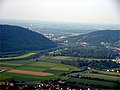
City of Porta Westfalica in the Porta Westfalica breakthrough in the Weser
Weser near Nienburg 
Weser Bridge in Thedinghausen 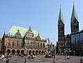
Destination :
The Bremen market square with town hall , Roland , cathedral and house of the citizens


The walk leads the hiker from the Weser Mountains through the North German Plain to Bremen. On the way he has to deal with 232 vertical meters up and 270 vertical meters downhill. The lowest points of the path are before and after Kirchweyhe ( 5 m above sea level ), at Binnen you reach 61 m above sea level. NHN the highest point.
Labelling
The Weserweg with the signpost -Markierung W marked.
Transitions
- In Porta Westfalica for
- Bückeberge-Weg ; Porta Westfalica → Bad Nenndorf , 51 km ( X11 )
- Burgensteig ; Porta Westfalica → Höxter , 115 km ( X2 )
- Cheruskerweg ; Serpentine → Porta Westfalica, 70 km ( X3 )
- European long-distance footpath E11 ; Scheveningen ( Netherlands ) → Gołdap ( Poland ), 2,500 km ( X E11 )
- Rune path ; Porta Westfalica → Schlangen, 74 km ( X7 )
- Weserberglandweg ; Hann. Münden → Porta Westfalica, 225 km ( XW )
-
Wittekindsweg ; Barkhausen → Osnabrück , 95 km (
 )
)
- In Nienburg to the Roswithaweg ; Nienburg → Bad Gandersheim , 193 km ( XR )
- In Bremen to the Unterweser-Weg ; Bremen → Cuxhaven , 157 km (yellow direction arrow, green border)
See also
Web links
Individual evidence
- ^ The Bückeberg Weg at Schaumburger Land Tourismusmarketing
- ↑ The Roswithaweg at Mittelweser-Touristik
- ↑ The Unterweser-Weg at the Northern German Hiking Association