Saint-Germain-sur-Avre
| Saint-Germain-sur-Avre | ||
|---|---|---|

|
|
|
| region | Normandy | |
| Department | Your | |
| Arrondissement | Evreux | |
| Canton | Verneuil-sur-Avre | |
| Community association | Evreux Portes de Normandie | |
| Coordinates | 48 ° 46 ′ N , 1 ° 16 ′ E | |
| height | 88-140 m | |
| surface | 5.39 km 2 | |
| Residents | 1,177 (January 1, 2017) | |
| Population density | 218 inhabitants / km 2 | |
| Post Code | 27320 | |
| INSEE code | 27548 | |
| Website | http://saintgermainsuravre.jimdo.com/ | |
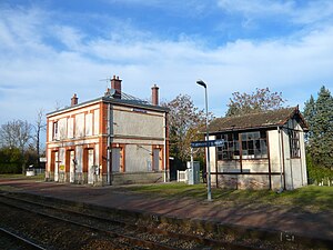
 Saint-Germain / Saint-Rémy train station |
||
Saint-Germain-sur-Avre is a French commune with 1,177 inhabitants (as of January 1 2017) in the Eure in the region of Normandy . It belongs to the Arrondissement of Évreux and the Canton of Verneuil-sur-Avre (until 2015: Canton Nonancourt ). The inhabitants are called Saint-Germinois .
geography
Saint-Germain-sur-Avre is located about 30 kilometers south-southeast of Évreux on the Avre . Saint-Germain-sur-Avre is surrounded by the neighboring communities of Courdemanche in the north, Mesnil-sur-l'Estrée in the east, Vert-en-Drouais in the south-east, Saint-Rémy-sur-Avre in the south and south-west and La Madeleine-de -Nonancourt to the west and northwest.
history
| year | 1793 | 1846 | 1881 | 1936 | 1962 | 1968 | 1975 | 1982 | 1990 | 1999 | 2006 | 2013 |
|---|---|---|---|---|---|---|---|---|---|---|---|---|
| Residents | 490 | 655 | 556 | 423 | 381 | 336 | 464 | 665 | 1,026 | 1,128 | 1,197 | 1,210 |
Culture and sights
- Saint-Germain-d'Auxerre church from the 14th century
- Mill
Individual evidence
- ↑ Saint-Germain-sur-Avre on Cassini.ehess.fr (French) Retrieved October 1, 2016.
