Moisville
| Moisville | ||
|---|---|---|
|
|
||
| region | Normandy | |
| Department | Your | |
| Arrondissement | Evreux | |
| Canton | Verneuil-sur-Avre | |
| Community association | Evreux Portes de Normandie | |
| Coordinates | 48 ° 50 ′ N , 1 ° 10 ′ E | |
| height | 146-159 m | |
| surface | 6.99 km 2 | |
| Residents | 238 (January 1, 2017) | |
| Population density | 34 inhabitants / km 2 | |
| Post Code | 27320 | |
| INSEE code | 27411 | |
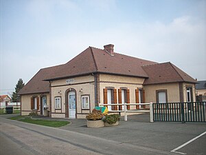
 Moisville Town Hall (Mairie) |
||
Moisville is a French municipality with 238 inhabitants (at January 1, 2017) in the Eure in the region Normandy (before 2016 Haute-Normandie ). It belongs to the Arrondissement of Évreux and the Canton of Verneuil-sur-Avre (until 2015 Nonancourt ). The inhabitants are called Moisvillois .
geography
Moisville is about twenty kilometers south of Évreux . Moisville is surrounded by the neighboring municipalities of Mesnils-sur-Iton in the north and west, Chavigny-Bailleul in the north and northeast, Coudres in the east and Marcilly-la-Campagne in the south and east.
The national route 154 runs through the municipality .
| year | 1793 | 1846 | 1881 | 1936 | 1962 | 1968 | 1975 | 1982 | 1990 | 1999 | 2006 | 2013 |
|---|---|---|---|---|---|---|---|---|---|---|---|---|
| Residents | 242 | 253 | 186 | 131 | 150 | 158 | 170 | 148 | 151 | 167 | 193 | 186 |
Attractions
- Saint Martin church from the 13th century
Trivia
Paul Celan owned a house here in the 1950s and 1960s.
Web links
Commons : Moisville - collection of images, videos, and audio files
Individual evidence
- ↑ Moisville on Cassini.ehess.fr (French) Accessed January 22, 2018th

