
Le Val-Doré
| Le Val-Doré | ||
|---|---|---|
|
||
| region | Normandy | |
| Department | Your | |
| Arrondissement | Evreux | |
| Canton | Conches-en-Ouche | |
| Community association | Pays de Conches | |
| Coordinates | 48 ° 56 ' N , 1 ° 2' E | |
| height | 95-175 m | |
| surface | 20.17 km 2 | |
| Residents | 921 (January 1, 2017) | |
| Population density | 46 inhabitants / km 2 | |
| Post Code | 27190 | |
| INSEE code | 27447 | |

Le Val-Doré is a French municipality with 921 inhabitants (as of January 1 2017) in the department of Eure in the region of Normandy . It belongs to the Arrondissement of Évreux and the canton of Conches-en-Ouche and the Pays de Conches community . The inhabitants are called Orvauxiens .
Le Val-Doré was formed on January 1, 2018 as Commune nouvelle from the previously independent communes of Le Fresne , Le Mesnil-Hardray and Orvaux .
structure
| District | former INSEE code |
Area (km²) | Population as of January 1, 2017 |
|---|---|---|---|
| Le Fresne (administrative headquarters) | 27268 | 9.13 | 328 |
| Le Mesnil-Hardray | 27402 | 4.84 | 74 |
| Orvaux | 27447 | 6.20 | 519 |
geography
Le Val-Doré is located about 15 kilometers southwest of Évreux between the Roulou and Iton rivers . Le Val-Doré is surrounded by the neighboring communities of La Croisille and Champ-Dolent in the north, Gaudreville-la-Rivière in the north and northeast, Les Ventes in the east, Sylvains-Lès-Moulins in the east and southeast, and Nogent-le-Sec in the south , Nagel-Séez-Mesnil in the west and south-west, Couches-en-Ouche in the west and north-west and Saint-Élier in the north-west.
Attractions
- Saint-Léonard church in Le Fresne
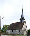
- Notre-Dame church in Le Mesnil-Hardray, monument historique since 1953
- Notre-Dame church in Orvaux
Saint-Léonard church

Notre-Dame church in Le Mesnil-Hardray

Notre-Dame church in Orvaux


Web links
Individual evidence
- ↑ Anne Laparre-Lacassagne: Recueil des actes administratifs spécial n ° 27-2017-126. Arrêté 27-2017-09-21-008 créant la commune nouvelle Le Val-Doré. September 21, 2017, accessed January 19, 2018 (French).
- ↑ current population according to INSEE