Iton
| Iton | ||
|
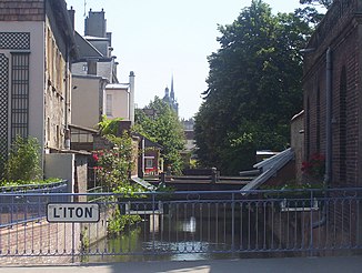
The Iton in the city of Évreux |
||
| Data | ||
| Water code | FR : H43-0400 | |
| location | France , Normandy region | |
| River system | His | |
| Drain over | Your → Seine → English Channel | |
| source | in the municipality of Mahéru 48 ° 40 ′ 28 ″ N , 0 ° 26 ′ 53 ″ E |
|
| Source height | approx. 288 m | |
| muzzle | at Acquigny in the Eure coordinates: 49 ° 10 ′ 29 " N , 1 ° 11 ′ 11" E 49 ° 10 ′ 29 " N , 1 ° 11 ′ 11" E |
|
| Mouth height | approx. 20 m | |
| Height difference | approx. 268 m | |
| Bottom slope | approx. 2 ‰ | |
| length | approx. 132 km | |
| Catchment area | approx. 1197 km² | |
| Discharge at the Normanville A Eo gauge : 1031 km² |
MQ Mq |
3.6 m³ / s 3.5 l / (s km²) |
| Left tributaries | Rouloir | |
| Medium-sized cities | Evreux | |
The Iton is an approximately 132 km long river in the Orne and Eure departments in Normandy in northern France . It rises in the municipality of Mahéru , in the Perche region , and generally drains in a north-easterly direction; finally it flows into the Eure at Acquigny .
Hydrology
In its upper reaches, between Bourth and Francheville , the Iton was artificially split up
- south over the Bras forcé de Verneuil to Verneuil-sur-Avre , where it flows into the Avre , and
- north over the Bras forcé de Breteuil to Breteuil , to then reunite with the main arm above Condé-sur-Iton .
- The main arm itself is largely lost in a wetland under the name Iton Morte and only receives adequate water flow after 14 km when it reunites with the northern tributary.
Another special feature can be found in the section of the river between Orvaux and Glisolles . There the Iton suddenly disappears from the surface and runs in underground chalk karst caves. This 10 km long section is called Iton Sec (“dry Iton”). At Glisolles the water comes to the surface again, part of it over the karst spring La Fosse aux Dames .
Places on the river
- Bonsmoulins
- Les Aspres
- Saint-Ouen-sur-Iton
- Bourth
- Francheville , municipality of Verneuil d'Avre et d'Iton
- Breteuil
- Damville
- La Bonneville-sur-Iton
- Saint-Sébastien-de-Morsent
- Evreux
- Gravigny
- Acquigny
Web links
Individual evidence
- ↑ a b geoportail.fr (1: 16,000)
- ↑ Water information system Service d'Administration National des Données et Référentiels sur l'Eau (French) ( information ), accessed on July 7, 2009, rounded to full kilometers
- ↑ hydro.eaufrance.fr (station: H9402030 , option: Synthèse )
