Richard-Boljahn-Allee
| Richard-Boljahn-Allee | |
|---|---|
| Street in Bremen | |
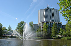
| View to the west; Foreground and right: Neue Vahr Nord, middle Aalto high-rise , behind and to the left Neue Vahr Süd, in between the green ribbon of Richard-Boljahn-Allee | |
| Basic data | |
| city | Bremen |
| district | Vahr |
| Created | 20th century |
| Cross streets | In Vahr , Bürgermeister-Spitta-Allee , Henri-Dunant- Strasse, Karl-Kautsky- Strasse, Friedrich-Stampfer- Strasse, Autobahn A 27 |
| use | |
| User groups | Cars, bikes and pedestrians |
| Road design | four lane road |
| Technical specifications | |
| Street length | 2250 meters |

The Richard-Boljahn Avenue is a major thoroughfare in Bremen , district Vahr , districts Neue Vahr Nord and Neue Vahr southwest. As a motorway feeder, it leads mainly in a west-east direction from Kurfürstenallee in Schwachhausen to federal motorway 27 (exit no. 20 Bremen-Vahr ) and Franz-Schütte-Allee to Oberneuland .
The cross streets and connecting streets were named u. a. as Kurfürstenallee in 1910 after the originally (1257) seven and finally (1803) ten electors of the Holy Roman Empire , who had the right to elect a king , In the Vahr after the district (it was previously part of Vahrer Straße), Bürgermeister-Spitta-Allee after the politician ( DDP , BDV and FDP ) Theodor Spitta (1873–1969), Henri-Dunant- Strasse after the Swiss founder of the International Committee of the Red Cross (1828-1910), Karl-Kautsky- Strasse after the German / Austrian philosopher and social democratic politician (1854–1938), Friedrich-Stampfer- Strasse after the journalist (editor-in-chief of Vorwärts ) and politician (SPD) (1874–1957), Autobahn A 27 and Franz-Schütte-Allee after the merchant, oil importer and important patron Franz Schütte (1836–1911); otherwise see the link to the streets.
history
Surname
Richard-Boljahn-Allee was named in 1993 after the politician ( SPD ), trade unionist as the Bremen DGB chairman and long-time leader of the SPD parliamentary group in the Bremen citizenship Richard Boljahn (1912-1992).
He was also chairman of the supervisory board of the Gewoba housing company . He was instrumental in building the Neue Vahr.
The street was previously part of Franz-Schütte-Allee.
development
After the Second World War , in 1956 a master plan and then development plans for the development of the Vahr were drawn up. The Neue Vahr was built on both sides of the avenue with around 11,800 apartments for 30,000 residents on 218 hectares, divided into five neighborhoods. The Gewoba - between New home - was the housing company that made create most of the apartments. The Vahr is a very green large housing estate , mostly in a row construction , in which there are also row houses and individual houses.
traffic
The road in Goh Hollerland was an old route through the Vahrer Feld to Oberneuland.
In the 1960s, the road was expanded into an intersection-free expressway with a top speed of initially 80 and then 70 km / h. Around 30,000 drivers drove on this road every day in 2010. In 2014, in addition to the pedestrian bridges, pedestrian traffic lights were set up in three places. and therefore reduced the top speed from 70 to 50 km / h; with approval and also strong criticism.
In local transport in Bremen, bus lines 739 (Bremen - Posthausen ) pass through the street without stopping and bus lines 21 (Blockdiek ↔ Universität-Nord) and 24 (Rablinghausen ↔ Neue Vahr-Nord) touch the street at Bürgermeister-Spitta-Allee.
Buildings and facilities
The street is built on with three to 21-storey houses.
Notable buildings and facilities
South side
- In Vahr No. 64 at the corner of Richard-Boljahn-Allee: 1-gesch. modern house with a white roof and a restaurant
- No. 1: 3-sch. Auto technology business building
- Henri-Dunant-Strasse No. 3: 1-gesch. Commercial building of the Mercedes-Benz branch
- District heating power plant for the Vahr
- Pedestrian bridge with paths to Kurt-Schumacher-Allee and Carl-Severing- Strasse
- Karl-Kautsky-Strasse bridge
- Berliner Freiheit , district center from around 1960 with 2-storey. Shopping center from 2003 with around 65 shops, Sparkasse, Vahr community center , weekly market and multi-storey car park as well as the 4- to 5-storey. Hanna Harder House as an AWO senior citizens' housing complex
- Berliner Freiheit: 21-storey, 65-meter-high Aalto skyscraper by Gewoba from 1961 with 189 apartments based on plans by Alvar Aalto , Helsinki
- Park with Lake Vahr based on plans by Karlaugust Orf, Bremen
- Pedestrian bridge with paths to Kurt-Schumacher-Allee and Heinrich-Schulz- Strasse
- Dietrich-Bonhoeffer-Strasse No. 37: 13-gesch. High-rise residential building from around 1967
- Pedestrian bridge with paths to Geschwister-Scholl-Strasse and the allotment area
North side
- Papendieckstraße: single-family house area
- Philipp-Scheidemann -Straße and Carl-Severing -Straße: 3-, 4- and 8-gesch. Residential houses of the Neue Vahr Nord
- Friedrich-Stampfer-Strasse and Julius-Bruhns -Strasse : 3-, 4-, 5- and 8-storey. Residential houses of the Neue Vahr Nord
- Julius-Bruhns-Strasse No. 2: 14-gesch. Residential high-rise
- Allotment area
See also
literature
- Herbert Black Forest : The Great Bremen Lexicon. 2nd, expanded and updated edition. In two volumes. Edition Temmen , Bremen 2003, ISBN 3-86108-693-X (first edition: 2002, supplementary volume A – Z). 2008, ISBN 978-3-86108-986-5 .
- Monika Porsch: Bremer Straßenlexikon , complete edition. Schünemann, Bremen 2003, ISBN 3-7961-1850-X .
Individual evidence
- ^ CH Heinecken: Map of the Gohgrafschaft Hollerland from 1796
- ↑ NWZ from 2014: Controversial traffic lights put into operation. Transport Senator Reinhard Loske (Greens) put the traffic lights into operation on Monday .
- ↑ Solveig Rixmann: Richard Boljahn-Allee is a Aufreger . In: Weser-Kurier from Jan. 20, 2013.
Coordinates: 53 ° 4 ′ 57.2 ″ N , 8 ° 53 ′ 27.1 ″ E


