Osterdeich
| Osterdeich | |
|---|---|
| Street in Bremen | |
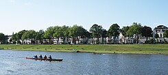
| The Osterdeich seen from the left bank of the Weser | |
| Basic data | |
| city | Bremen |
| Districts | Old town, Ostertor, Steintor, Peterswerder |
| Created | from 1850 |
| Newly designed | 1930 |
| Cross streets |
Mozartstrasse , Deichstrasse, Oberweserstr. , Reederstr. , Sielwall , Lübecker Str., Lüneburger Str., Celler Str., Auf dem Peterswerder , Harzburger Str., Ilsenburger Str.,
Verdener Str., Wernigeroder Str., Blankenburger Str., Treseburger Str., Clausthaler Str., Schierker Str. Stader Str., Herzberger Str., Poelzigstr ., Georg-Bitter- Str. and Hastedter Brückenstr. |
| use | |
| User groups | Pedestrian traffic , bicycle traffic , car traffic |
| Road design | Double lane, one-sided bike path, promenade |
| Technical specifications | |
| Street length | 3000 meters |
The Osterdeich is a street and a dike in Bremen .
The street begins in Bremen's old town at the corner of Altenwall / Tiefer and leads through the districts of Ostertor and the district of Ostliche Vorstadt with the districts of Steintor and Peterswerder to the district of Hastedt in the Hemelingen district , where it continues as Hastedter Osterdeich . The Osterdeich is thus one of the major roads in Bremen.
At the same time, the Osterdeich is part of the eponymous eastern dike on the right side of the Weser in the area between the city center and the Weser weir . It separates the flooded area from the residential area and is therefore only built on on one side.
The cross streets were u. a. named after places (mainly in the Harz), districts and people; Otherwise see the link to the streets .
history
Surname
The Osterdeich was named after the old name of the eastern dykes on the Weser. On the Neustadt side there are the names Westerstraße .
precursor

- The Punkendeich reached from the hill of the Paulskloster on the outside of the moat to the Siel des Dobbens on today's Sielwall road . This dike was initially called Sielwall, but was officially called in the 18th and 19th centuries, then Punkenwall, probably by the Punken , the prostitutes who lived there;
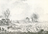
- The Eisenradsdeich or dyke at the iron wheel (incorrectly also Theisenradsdeich ) extended from the Siel des Dobben to the Peterswerder, two small islands in the foreland of the dike. Its name refers to an iron wheel on the said sluice. This section of the dike lay on the slope of a bend in the Weser and was therefore at great risk during high tides. To reduce the risk, a 60-meter-long loop was created in the 17th century that protruded from the Peterswerder into the river.
- The Langendeich or Kleine Deich connected the end of the Eisenradsdeiches with the Bremen dune, on which it ran a little way next to the road to Sebaldsbrück and Verden ( Am Schwarzen Meer and Am Hulsberg ). Although it was further away from the river than today's dike , with the Pauliner Marsch as the dike foreland, it broke several times.
- In Hastedt, which has only belonged to Bremen since 1803, there was only a short piece of dike from the old state border at the three piles to the town center. Upriver, the dunes were relied on for natural protection.
Today's Peterswerder district and the southern half of today's Hastedt were at that time foreland of the dike. A trench with two small ponds branched off from the river across from habenhausen and rejoined at Peterswerder.
The dike breaches at Eisenradsdeich in 1827 and Hastedter Deich in 1830 caused widespread flooding. As with the even more frequent breakthroughs at Mahndorf, the water mostly ran into the Wümmen lowlands , especially since the Gete von Hastedt and the small Wümme von Osterholz flowed north.
Today's Osterdeich
Flood protection
From 1850 to 1893 these dikes were replaced by today's southern Osterdeich, starting at the wooden gate on the Tiefer . The city moat in the Bremen ramparts was separated in 1850 by a dam with a sewer instead of a sluice. The Dobben was completely filled in.
The work was intensified after the devastating floods of spring 1881, in which almost all of Bremen (with the exception of the old town and the high-lying parts of Vegesack ) was flooded. Bremen then had to undertake to secure the railway lines in its area from flooding.
The construction of the Osterdeich enabled increasing settlement of the former floodplains. Many villas and terraced houses in the architectural styles of Classicism , Historicism and Art Nouveau for one or two families were built here.
Green areas and leisure facilities
The green area at Osterdeich is part of the dike. It leads as a promenade for around 3 km along the Weser from the Tiefer, past the ramparts, the Sielwall ferry, the Weser Stadium and the Stadionbad, over the Pauliner Marsch to Hastedter Brückenstraße. The hiking trail on the Weser is a scenic route for recreation.
The four bathing establishments on the Osterdeich are said to have been bathing ships that were located on the Osterdeich from around 1860 to around 1890/1900. Around 1900 the bathing establishment on Werderstrasse on the left bank of the Weser was relocated to Osterdeich near Sielwall . By 1900 the Osterdeichwiesen were already popular as green spaces. The beach promenade in the area of the Sielwall pier was busy.
From 1904, Georg Bitter and the Swiss gardener Ernst Nussbaumer created the botanical garden on Osterdeich , which was donated by Franz Ernst Schütte . In 1937 it was relocated next to the newly established Rhododendron Park .
In 2005 the outside area around the Weserterrassen community center was redesigned. The cultural center and the café were spatially connected to the heavily used green space on the lower Weser promenade with a new set of steps.
Osterdeich as a road
The dike cap (dike crown) was given a roadway around 1850 that led to the Sielwall until 1867. The dike was planted with trees in 1861. A promenade was built on and in front of the dike. From 1873 to 1893 the road to Hastedt was also expanded. The water supply from the water tower on the Werder took place from 1873, the sewer system from the end of the 19th century, the gas supply in sections from 1850 and the power supply from the 1890s.
In 1930 the road was expanded as part of "emergency works" during the Great Depression and became a busy avenue and trunk road, until 1999 it was part of the B75 . Significant cross streets are from west to east:
- The Sielwall at the Sielwall ferry leads to the Dobben,
- Lüneburger Strasse at the Weserterrassen community center leads to the Bremen-Mitte Clinic on St.-Jürgen-Strasse,
- The Verdener Straße leads to the Straße Am Schwarzen Meer ,
- Stader Strasse leads to Bismarckstrasse ,
- The Hastedter Brückenstraße leads south over the Weser and the Karl-Carstens-Bridge ( Erdbeerbücke ) to habenhausen and Arsten ,
- The Georg-Bitter-road leads north to the garden city Vahr and after Schwachhausen .
The eastern part of the original Osterdeich was separated around 1950 (1951 at the latest) and was given the name Hastedter Osterdeich .
Ferries from Osterdeich
A ferry has been going from Dobbensiel on Punkendeich over the Weser since 1736 and later from Sielwall to Stadtwerder . In 1984 the Hal Över association took over the operation of the Weser ferry between Sielwall on the right bank of the Weser and Café Sand. The Sielwall ferry is still used actively today. In 1965 the flagpole was erected in the west. With short interruptions there is still a ferry service for today's Sielwall ferry . From 1914 to 1968 a motorboat ferry also drove from Peterswerder.
Events at the Osterdeich
- On Punk dike which takes place since 1829 each year on January 6, Epiphany , the Bremer Eiswette instead.
- The Breminale has been a five-day open-air festival on Osterdeich since 1987, which was attended by 150,000 participants.
- The Bremen Marathon has also been running over the Osterdeich since 2005.
Buildings and facilities


From 1856 after the construction of the Osterdeich numerous villas of wealthy citizens were built. After the First World War and increasingly after the Second World War , many apartments were and are used as offices.
- Osterdeich / corner Altenwall: Here the Osterdeich touches the Bremen ramparts , which encompass the old town. The facilities were built between 1803 and 1811. The Kunsthalle Bremen , Altmannshöhe and the nearby theater on Goetheplatz are located in the Osterdeich area .
- Osterdeich 2: Parking garage Ostertor (also theater garage ) with the three-story residential building from the 1980s above. The historicizing representative and large villas stood here until 1942/44:
- Osterdeich 1: Villa Plump (later called Mägdeburg ) from 1855 for August Theodor Plump (1811–1890), who came from an old merchant family; from 1897 owned by tobacco merchants Eberhard Tölken (1846–1901) and Auguste ( Dora ) Tölken, b. Plump (1857-1919)
- Osterdeich 2: Villa Wätjen from 1858/61 according to plans by Heinrich Müller for the shipowner Christian Heinrich Wätjen ; Demolished in 1933
- Osterdeich 3: Villa Fritze from 1862 in neo -renaissance style based on plans by Heinrich Müller for the businessman Philipp Richard Fritze (1823–1883), from 1917 Villa Roselius for the coffee merchant Ludwig Roselius
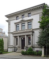
- Osterdeich 4 / Mozartstraße 15: The two-storey Villa Büsing from historicism with a semicircular porch was built in 1863 by the building contractor Lüder Rutenberg according to plans by Heinrich Müller in the classicism style. The house has been a listed building since 1973.
- Osterdeich 6: The four-storey Pavenstedt house dates from 1863, was renovated in 1982 and, as Janusz-Korczak - house, was the seat of the State Center for Civic Education in Bremen and the German-Polish Society in Bremen .
- Osterdeich 7 to 16: Three to four storey residential and office buildings, mostly in the classical style
- Osterdeich 17: Haus Hirschfeld is a villa that was built for the tobacco merchant G. R. Hirschfeld from 1898 to 1899 according to plans by Eduard Gildemeister and Wilhelm Sunkel in the historicist style. The three-storey residential building has a corner tower and a gable and inside a spacious staircase with a gallery. The house has been a listed building since 1992. For a long time it was the home of Adalbert Oskar Korff, partner of the C. Melchers company and later the seat of the Higher Administrative Court of the Free Hanseatic City of Bremen .
- Osterdeich 18 to 26: Three to five-story residential and office buildings
- Osterdeich 27: Initially there were smaller houses with apartments and an inn, which became Heinrich Bach's coffee house in early 1870. After the demolition of these houses, the merchant Adolf Frerichs had the representative two-and-a-half-story Villa Frerichs built from 1882 to 1884 according to plans by Johann Georg Poppe in the style of the historicism of the Wilhelminian era in the neo-Renaissance style. The house has a heavily decorated front with a small central gable. Inside there is a central flight of stairs and a hall of mirrors. Pillars, ceilings and walls are decorated with stucco . After the death of Frerichs, shortly after completion, his widow lived in the villa for decades and rented some rooms after the First World War. From 1922 the merchant Walter Haux lived here for a short time. In the 1930s only a few rooms were rented. In 1940 parts of the staff and in 1941 the command staff of the 8th Flak Division were housed, which then had its headquarters in a bunker on Parkallee in 1942 . After the Second World War, the Senator for Education occupied rooms until 1955, then the Institute for Shipping Research and then the Office for Family Welfare. From 1970 to 1986 this was the post office's apprentice home and at times the municipal child benefit fund. From 1986 to 1992, Caritas housed migrants and asylum seekers here. In 1992 the Scientologists' training center was domiciled here for a few months . The doctor and business economist Jens Koberstein bought the building for 2.6 million marks and began to set up a medical center with 15 specialist practices. After the investor's financial difficulties, the house fell back to its previous owner Werner Schalm. The house, which was renovated in 2004/05, has been a listed building since 1973. A new anchor tenant has been using the house for a company and eight apartments since 2011.
- Osterdeich 29/30: Two two-story neo-classical villas with a rich decoration
- Osterdeich 31: Rust-free building of the New Apostolic congregation Bremen-Ostertor
- Osterdeich 32 to 41: four to five storey residential buildings; The merchant and art lover Julius Focke (1872–1937) is said to have lived in an earlier house at no.
- Osterdeich 42/43: Two-story church building of the free-church Advent community in Bremen-Mitte
- Osterdeich 44 to 51: Two to three-story residential and office buildings
- Osterdeich 53: Turmhotel Weserblick with Werdertreff restaurant
- Osterdeich 54 to 55: Five-story residential buildings
- Osterdeich / corner of Sielwall: Primary school with three construction phases, two to three-story buildings from the 1960s and 1970s, a fresco adorns the west gable
- Osterdeich 57 to 59a: Three-story residential buildings
- Osterdeich 59b: Haus Heinemann was built in 1928 according to plans by Heinrich J. Kayser . The Rotstein clinkered, two-story house with a large hipped roof in the style of the interwar period has been a listed building since 1995. Today the Villa Sponte is located here .
- Osterdeich 59c to 63: three- to four-story modern residential buildings
- Osterdeich 62: Four-story residential building, built in 1956 by the Bremen architect Fritz Söhlke. The building was the first new building on Osterdeich after the Second World War.
- Osterdeich 64: The Villa Wolde was built from 1896 to 1898 by the builder Diedrich Tölken for the private banker Heinrich August Wolde according to plans by Martin Haller, who was mostly active in Hamburg . The two-story house with an additional mezzanine floor has been a listed building since 1998.
- Osterdeich 65 to 70: Two to three-story residential and office buildings
- Osterdeich 70a / 71: St. Petri cathedral chapel of the Protestant cathedral parish from 1965 based on plans by Friedrich Schumacher and Claus Hübener.
- Osterdeich 69/70: The only building complex on Osterdeich is on the side facing the Weser. In 1928 the Ottilie Hoffmann House of the abstinence movement opened in a Bauhaus style building . Today the Weserterrassen community center and a café are located here.
- No. 69a: The three-storey terraced building from 1928/29 based on plans by A. Karst now houses the Ambiente Café of the Bürgerhaus Weserterrassen GmbH .
- No. 70b: The two-storey town house Weserterrassen with red
- The Franz-Böhmert -Straße leads to the Weserstadion and adjacent Stadionbad
- The first forerunner of the Weser Stadium from 1909 was a sports field with a wooden grandstand. In 1926 a new stadium with a grandstand was named ABTS-Kampfbahn . The facility has been called the Weserstadion since 1930 and is the venue for Werder Bremen with currently (as of 2011) 43,500 seats.
- The street Jürgensdeich - near Hastedter Brückenstraße - leads to the Restaurant Jürgenshof , which belonged to the Paulskloster in the Middle Ages , since 1560 to the structure of the Bremen Cathedral and since 1803 to the city of Bremen.
- at nos. 109 to 121, corner turrets adorn some of the historicizing houses
- No. 108 to 109a: Red stone-visible residential buildings, typical of the 1920s
See also
literature
- Herbert Black Forest : The Great Bremen Lexicon . Edition Temmen , Bremen 2003, ISBN 3-86108-693-X .
- Herbert Black Forest: History of the Free Hanseatic City of Bremen . Volume II – III, Edition Temmen, Bremen 1995, ISBN 3-86108-283-7 .
- Johann-Günther König: The Osterdeich . Kellner-Verlag, Bremen 2017, ISBN 978-3-95651-109-7 .
Individual evidence
Web links
Coordinates: 53 ° 4 ′ 3.3 " N , 8 ° 50 ′ 22.8" E


