Parkallee (Bremen)
| Park avenue | |
|---|---|
| Street in Bremen | |
| Parkallee location | |
| Basic data | |
| city | Bremen |
| Districts | Schwachhausen |
| Created | 1888 |
| Hist. Names | Kuhgrabenweg, Stauallee |
| Buildings | High school at the Barkhof |
| use | |
| User groups | Pedestrian traffic , bicycle traffic , individual traffic , public transport |
| Technical specifications | |
| Street length | 3.3 km |
The Park Avenue in Bremen is approximately 3.3 km long arterial road between the hamlets Ostertor and Lehe . It is an important axis of inner-city traffic and the shortest connection from the city center to the university campus .
course
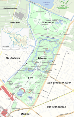
As an extension of Rembertistraße, Parkallee begins in the Ostertor "quarter" southeast of the main station at the intersection with the An der Weide street - except for Schleifmühle , where the Parkallee 1 property is located. The Friedenstunnel crosses under the Wanne-Eickel-Hamburg or Wunstorf-Bremen railroad and reaches the Schwachhausen district , where after a short section through the Barkhof district , which is designated as a bicycle road, the heavily frequented Am Stern traffic circle with a total of six entrances is reached becomes. There, on the left, the Bürgerpark begins , which, together with the city forest to the north, is the second largest contiguous park in Bremen (after the park on the left of the Weser ).
The route continues between the Bürgerpark and Schwachhausen / Neu-Schwachhausen districts in the direction of the university, where, after crossing the railway again, the Parkallee becomes the Universitätsallee . From this the BAB feeder leads to the Horn-Lehe junction of BAB 27 .
Out of town, the following streets branch off from Parkallee behind the Friedenstunnel: Hohenlohestraße, Delbrückstraße, Goebenstraße / Am Barkhof, Parkstraße, Am Stern roundabout with Hollerallee and Hermann-Böse-Straße / Wachmannstraße, Altmannstraße, Benquestraße, Franziusstraße, Bulthauptstraße, Otto-Gildemeister- Straße, Fitgerstraße, Schwachhauser Ring, Coccejusstraße, Emmastraße, Busestraße, Kulenkampffallee , Zur Munte and Achterstraße.
The bus line 22 of the Bremer Straßenbahn AG leads over the northern part of the Parkallee.
history
Surname
The Park Avenue was called until 1888 Kuhgrabenweg , named after the later to the little ones Wümme filled- Kuhgraben , and by 1890 congestion Allee , after the court congestion (named after the case contained impoundment of Kuhgrabens) in the Feldmark Pagentorn. In January 1890 it was decided to rename it to Parkallee.
development
In pre-industrial times, the Kuhgraben ran along today's Parkallee from the Wümme towards the city center, where it connected to the Dobben to the south of today's railway underpass .
During the development of the Pagentorn Feldmark in the 19th century, the Stauallee was laid out parallel to the Kuhgraben. In 1890 the southern part of the Kuhgraben was filled in, the part up to the traffic jam in 1893. On the Kuhgraben area gained in this way, the street now called Parkallee was paved and widened. The Pagentorn farmers gradually sold their farms on Parkallee as building land, and in 1898 the street name “Parkallee” appeared in the address book for the first time.
In order to secure its character as a residential street, the city ordered a special development plan for the Bürgerparkallee in 1891 . No commercial operations were allowed to be built, only residential houses and associated outbuildings, the latter only thirty meters away from the street front. No more than two houses next to each other were allowed. At least a third of the width of the building site had to remain undeveloped and the smallest depth of the front gardens had to be ten meters. These provisions were valid until 1940.
traffic
In April 1891 a petroleum railway went into operation on Parkallee, but was shut down again in 1893 after various breakdowns.
The Parkbahn operated on Parkallee from September 1910 to December 1911 .
Buildings and facilities


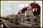
On Parkallee there are one to four-story buildings, mostly residential and commercial buildings. To the north of the star , Parkallee is only built on on the east side, as the Bürgerpark and Stadtwald are to the west. These houses were built as villas , so the eastern side is lined with some listed and architecturally significant houses, including:
- St. Catharinenstift , Parkallee 2, corner of Hohenlohestrasse, built in 1912.
- Villa Sowerbutts at Parkallee 30, built 1902–1903.
- Villa Kulenkamp at Parkallee 32, built in 1900.
- Oberschule am Barkhof in Parkallee 39, built 1903–1906.
- Villa Overbeck at Parkallee 48, built 1902–1903.
- Villa Otto , Schweneke's private teaching institute at Hollerallee 67 / Parkallee, built in 1900.
- Villa Korff in Parkallee 79/81 was built in 1903 for the oil merchant Wilhelm August Korff and housed the Bremen Regional Labor Court for a long time .
- Villa Dunkel at Parkallee 101 was built in 1897 according to plans by Albert Dunkel .
- Villa Hunckel at Parkallee 107, was built in 1900 according to plans by H. Bischoff.
- Villa Ahlers at Parkallee 117 was built in 1904 according to plans by Eduard Gildemeister and Wilhelm Sunkel.
- Villa Korff at Parkallee 133, was built between 1909 and 1910 according to plans by Hans and Heinrich Lassen for the merchant Heinrich Korff.
There are a few buildings on the west side, including the Schwachhausen police station and the Waldbühne in the Bürgerpark, built in 1890 as an exhibition pavilion for the Northwest German commercial and industrial exhibition .
During the Nazi era , two air raid shelters were built on Parkallee on the eastern edge of the Bürgerpark and have been preserved. At least in the second half of World War II , however, these were only available to the population to a very limited extent. The Wehrmacht command and other offices moved into bunker B31 at Benquestrasse. The bunker B32 across from the end of Bulthauptstraße initially served the 8th Flak-Division as a command post and later became known as "Government Bunker" from the NSDAP - district administration , the mayor and the police chief claimed. On April 26, 1945, Bremen's combat commander Werner Siber, who had been deposed three weeks earlier, surrendered to the advancing British troops.
In Fitgerstrasse and Franziusstrasse there are two more bunkers that have been converted into residential buildings.
Allotment colony
There is an allotment garden colony on the northeast side .
See also
literature
- Hanne lamp: The Pagentorn peasantry, Bremisches Jahrbuch 42nd volume. F. Trüjen, Bremen 1947, p. 150 ff.
Individual evidence
- ↑ Street directory of the city of Bremen at www.statistik.bremen.de, accessed on December 23, 2018
- ↑ Where there is a villa, there is also a path In: weser-kurier.de. Weser-Kurier, March 27, 2016, accessed April 1, 2016.
- ↑ wkgeschichte.weser-kurier.de 125 years ago: Opening of the Northwest German Trade and Industry Exhibition in the Bürgerpark on May 31, 1890 , accessed on July 9, 2020
- ^ Air raid shelter in Bremen - air raid shelter at www.relektiven.com, accessed on December 23, 2018
Coordinates: 53 ° 10 ′ 23 " N , 8 ° 37 ′ 3" E


