Treseburg
|
Treseburg
City of Thale
|
||
|---|---|---|
| Coordinates: 51 ° 42 ′ 57 ″ N , 10 ° 58 ′ 27 ″ E | ||
| Height : | 270 m | |
| Area : | 8.91 km² | |
| Residents : | 100 (Dec. 31, 2007) | |
| Population density : | 11 inhabitants / km² | |
| Incorporation : | July 1, 2009 | |
| Postal code : | 06502 | |
| Area code : | 039456 | |
|
Location of Treseburg in Saxony-Anhalt |
||
|
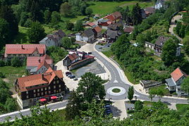
View from the “Weißer Hirsch” viewpoint of Treseburg
|
||
Treseburg is a district of Thale in the Harz district in Saxony-Anhalt , Germany. It was officially recognized as a climatic health resort in 2002 .
geography
Treseburg is located at the confluence of the Luppbode with the Bode southwest of Thale , on average 270 m above sea level. NN high in the Bodetal .
Below Treseburg (downstream) is the Bodetal nature reserve , through which a ten-kilometer hiking trail leads to Thale and the Roßtrappe . Another hiking trail goes from there over the heights and the Weißer Hirsch cliff to the Hexentanzplatz . Furthermore, the Bode-Selke-Stieg begins or ends here , which leads past the Frieda mine not far from the village . The Wilhelmsblick tunnel is located north of the village on the road towards Wienrode .
history
Ore mining probably began in Treseburg around 1400 or earlier. In the middle of the 15th century there was already a hut with a hut ditch. After a long interruption of operations, ore mining was resumed in 1714 and continued with further intermittent interruptions until 1777. The mine was named "Braunschweiger Zeche bei der Treseburg". At the end, the mine had an extension of 280 m in length and 700 m in depth. It was pebbles and copper pebbles , and in small amounts malachite , azurite and magnetic pebbles . A tunnel still exists today . However, the section under the Bode is under water.
The place owes its origin to the iron and copper mining which operated from the 15th to the 19th century . Up to 1784, wooden rafts were also assembled here, which were transported down to the Thaler Hütte. In 1877, the Treseburg schoolhouse with a chapel was built.
On April 19, 1945, nine boys between the ages of 15 and 17 were shot in the neck by US soldiers in a forest near Treseburg from a military training camp . Together with five Wehrmacht soldiers, they were buried in a communal grave in the Treseburg cemetery by residents as "unknown soldiers". When the young people were reburied in 1951, the mayor confirmed that the cause of death was a shot in the neck. Only one of the ten boys had managed to escape.
On July 1, 2009, the previously independent municipality of Treseburg was incorporated into the city of Thale.
politics
Local mayor
The local mayor of Treseburg is Mike Neubarth.
coat of arms
Blazon : "In silver a red tinned tower with silver breakthroughs over a red tinned bridge, each accompanied by a green spruce, below a black trout."
The coat of arms was designed in 1995 by the Magdeburg municipal heraldist Jörg Mantzsch . The approval by the Magdeburg Regional Council took place on April 1, 1997.
flag
The flag is red-white-striped lengthways and centered with the coat of arms.
economy
Treseburg is a holiday resort with cafes, restaurants, guest houses and hotels, such as the Hotel Bodeblick and the Hotel Forelle . There is a privately run clock museum in the village . It has over 500 exhibits on the history of timekeeping and photography. Treseburg is the starting point and destination of Bode valley hikes. In addition, the main hiking trails Harzer Hexenstieg and the HET-Weg (long-distance hiking trail Harz - Eichsfeld - Thuringian Forest) run by the Harz Club , as well as the Green Belt Germany through the town.
memorial
- There is a communal grave in the Treseburg cemetery with nine young people shot by American soldiers on April 19, 1945. A memorial stone has been bearing their names since June 2012 (until then: "Unknown soldiers").
Web links
Individual evidence
- ↑ Specification of health resorts and recreational areas in Saxony-Anhalt (as of March 2017) ( Memento of the original from December 30, 2017 in the Internet Archive ) Info: The archive link was inserted automatically and has not yet been checked. Please check the original and archive link according to the instructions and then remove this notice.
- ^ Robby Zeitfuchs and Volker Schirmer: Zeitzeugen. The Harz in April 1945 . Self-published, 2nd edition 2004, ISBN 3-89811-654-9 . Pp. 278-281
- ↑ StBA: Area changes from January 2nd to December 31st, 2009


