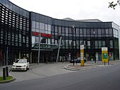
Alfred-Faust-Strasse
| Alfred-Faust-Strasse | |
|---|---|
| Street in Bremen | |
| Basic data | |
| city | Bremen |
| district | Obervieland |
| Created | 1970s |
| Cross streets | Brenningstr., Hans-Hackmack- Str., Herman-Entholt- Str., Emil-Richter- Str., Theodor-Billroth-Str. , Gustav-Deckwitz -Str., Wilhelm-Holzmeier -Str., Ludewigstr ., Wischmannstr., Richard-Liesche -Str., Brünyweg, Kuhweidedamm, Hanseatenweg , Donnerstedter Weg, Morsumer Str. |
| Buildings | Obervieland community center, Alfred-Faust-Strasse school, St. Hildegard's Church |
| use | |
| User groups | Cars, bikes and pedestrians |
| Road design | two lane road |
| Technical specifications | |
| Street length | 1600 meters |
The Alfred Faust Street is a street in predominantly east-west direction in Bremen in the district Obervieland , district Kattenturm. It leads from Kurt-Georg-Kiesinger- Allee to Dreyer Straße.
It is divided into the sub-areas:
- Hans-Hackmack-Straße to Gustav-Deckwitz-Straße (east-west)
- Gustav-Deckwitz-Straße to Brünyweg (north-south) and
- Brünyweg to Dreyer Straße (east-west).
The cross streets were u. a. named as Wischmannstrasse after the carpenter Caspar Heinrich Conrad Wischmann (1800-1854), Brünyweg after the broker Ferdinand Brüny, who tried to democratize Bremen in 1848, Kuhweidedamm after a field name, Hanseatenweg after the Hanseatic League , of which Bremen was a member, Donnerstedter Way to a district of Thedinghausen ; otherwise see the link to the streets.
history
Surname
Alfred-Faust-Straße was named after the editor, social democratic politician Alfred Faust (1883–1961).
Faust was a member of the Reichstag from 1932 to March 1933 .
He was held captive by the National Socialists in 1933/34 . From 1950 to 1961 he was press spokesman for the Senate of the Free Hanseatic City of Bremen .
development
Obervieland was created in 1598 when the Goh Vieland was divided. Around today's Alfred-Faust-Straße there was only arable land and meadows and in 1812 only about ten to fifteen residents lived in Kattenturm. Only after 1960 was the area opened up and residential buildings, commercial buildings and, in 1968, the Links der Weser Clinic (LdW) built. With the construction of the Karl-Carstens-Bridge in 1970/71 the Obervieland and via Brenningstraße the Alfred-Faust-Straße were connected with the right bank of the Weser. Today (2016) around 13,500 inhabitants live in the district of Kattenturm
traffic
The Bremen tram has been touching Alfred-Faust-Straße since 1973 with line 4 (before 1998 line 1), which runs from Arsten to Horn, since 2002 to Borgfeld and since 2014 to Lilienthal / Falkenberg.
In local transport in Bremen , the bus lines 51 (Huckelriede-Klinikum), 53 (Huckelriede-Brinkum-Nord Ochtum Park) and at night the N 9 run on Alfred-Faust-Straße.
Buildings and facilities

On the street there are one to six-storey buildings, most of which are residential buildings, with commercial buildings in the central area.
Notable buildings and facilities
- No. 1/3: 5-ply Residential and commercial building with u. a. the O´land house for disabled people and a pharmacy.
- No. 4: 1- to 3-layered Community center community center Obervieland (BGO) from 1977 and Schuldnerhilfe Bremen .
- No. 6: 3-sch. High school links the Weser as an all-day school
- No. 9: 2-sch. shopping mall
- No. 11: 4- / 5-layered Medical center
- Nt. 15: 5-sch. Office building u. a. of the trade association for trade and goods distribution .
- No. 17/19: 3-tiered Commercial and office buildings; behind a 2-tier Shopping center the stop Kattenturm-Mitte of the tram line 4 and a 15-gesch. Residential high-rise.
- No. 21: 3-sch. Business and office building with u. a. the branch of the Sparkasse Bremen .
- No. 23: Service apartments in the Obervieland building .
- The Obervieland local authority is located at 26 Gorsemannstrasse , and the Kattenturm police station next to it.
- Cato-Bontjes-van-Beek- Platz, named after the German resistance fighter against National Socialism , who was executed in Berlin-Plötzensee in 1943 . The square was redesigned in 2000.
- Kattenturmer Fleet
- No. 34: 3-sch. School on Alfred-Faust-Straße , a primary school from the 1970s with a gym.
- No. 45: 1-sch. Catholic St. Hildegard Church and community rooms from 1983 based on plans by the Walter Flügger and Gerd Schleuter working group, as well as a day-care center.
- No. 115: 1 to 3-layered Nursing home district house Kattenesch of the Bremer Heimstiftung , as well as crèche Wühlmäuse and a restaurant.
Monuments, plaques
- No. 4: City plan - rock garden by Wolfgang Michael, Almut Blume-Gleim and Elisabeth Grevenbrock-Zimmermann (1983).
- No. 4: Stone Age versus Concrete Age by Li Portenlänger (1983).
- No. 34: Brueghel'scher Bauerntanz by Horst Müller and Wolfgang Michael (1978).
- No.?: Obervielander past and present by Bert Haffke and Zoppe Voskuhl (1983).
- No.?: Sculpture alley in the sculpture workshop of the Oslebshausen correctional facility (1987).
See also
literature
- Herbert Black Forest : The Great Bremen Lexicon . 2nd, expanded and updated edition. In two volumes. Edition Temmen , Bremen 2003, ISBN 3-86108-693-X (first edition: 2002), supplementary volume A – Z. 2008, ISBN 978-3-86108-986-5 .
- Monika Porsch: Bremer Straßenlexikon , complete edition. Schünemann, Bremen 2003, ISBN 3-7961-1850-X .
Individual evidence
Coordinates: 53 ° 1 ′ 50 ″ N , 8 ° 49 ′ 24 ″ E
