Theodor-Billroth-Strasse (Bremen)
| Theodor-Billroth-Strasse | |
|---|---|
| Street in Bremen | |
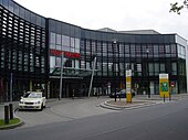
| Obervieland, middle left the shopping center | |
| Basic data | |
| city | Bremen |
| district | Obervieland |
| Created | 13th Century |
| Cross streets | Kattenturmer Heerstr. , On the Beguinage, Senator-Weßling-Str., Robert-Koch-Str., Emanuel-Backhaus-Str., Eichelnkämpe, Cato-Bontjes-van-Beek-Platz and Alfred-Faust-Str. |
| use | |
| User groups | Cars, bikes and pedestrians |
| Road design | two lane road |
| Technical specifications | |
| Street length | 1300 meters |
The Theodor-Billroth-Straße is a central thoroughfare in Bremen , district Obervieland , district Kattenturm . It mainly leads in a west-east direction from Kattenturmer Heerstraße to Alfred-Faust-Straße .
The cross streets and connecting streets were u. a. named as Kattenturmer Heerstraße after the Catteneschnertorme from 1390 or Kattenthorn , Auf dem Beguinland after the celibate women who lived as a Christian community in Bremen in two beguinages, Senator-Weßling-Straße after the politician ( SPD ) and Health Senator Karl Weßling (1911– 1968), Robert-Koch -Straße after the physician and microbiologist (1843-1910), Emanuel-Backhaus -Straße 1968 after the lawyer (1884-1958), politician ( NSDAP ) and president of the Bremen citizenship , who resigned in protest in 1933 resigned, Eichelnkämpe after a field name, Cato-Bontjes-van-Beek- Platz after the resistance fighter (1920–1943) and Alfred-Faust-Straße after the editor, social democratic politician Alfred Faust (1883–1961); otherwise see the link to the streets.
history
Surname
Theodor-Billroth-Straße was named after the important surgeon Theodor Billroth (1829-1894).
He is widely regarded as the founder of modern abdominal surgery and the pioneer of larynx surgery and bacteriology .
development
The Vieland was a flat, swampy land that was partially cultivated from 1201. Bremen gained state rights in the 14th century. In 1812 Kattenturm only had up to 15 inhabitants. The district of Kattenturm was shaped like a village before 1960, but today (2009) has 13,029 inhabitants. In 1962 Obervieland became a district. Theodor-Billroth-Straße became the central thoroughfare with the center for the town and district as part of the building development in the 1960s. The Links der Weser Clinic of the City of Bremen was built in the southern area from 1968 .
traffic
The then tram line 1 (since 1998 line 4) was extended from Arsterdamm to Kattenturm and Arsten in 1973 .
The Bremen tram runs today with line 4 ( Arsten - Lilienthal ) partly next to the street.
In local transport in Bremen, the road runs through bus lines 51 (Huckelriede ↔ Kattenturm Klinikum Links der Weser), 53 (Huckelriede ↔ Brinkum). The center can also be reached by bus lines 22 (Kattenturm-Mitte ↔ Universität-Ost), 29 (Kattenturm-M. ↔ Neue Vahr) and 52 (Huchting ↔ Kattenturm).
Buildings and facilities

There are mostly two and four-story buildings and several high-rise buildings on the street.
Notable buildings and facilities
South side
- No. 5/7: 2-sch. Building group with a new part of the general vocational school (ABS Obervieland / Theodor-Billroth-Straße) as well as rooms of the Bremen adult education center VHS-Süd; A secondary school and the Obervieland support center used to be here from around 1966 to 2010
- No. 33 and 43: Two 8-sided High-rise residential buildings of the 1960s
- No. 19 to 63: six 4-sided 1960s apartment buildings
- Senator-Weßling-Straße: Klinikum Links der Weser with 10 departments in several 2- to 10-storeys. Buildings for around 480 beds
- No. 67/71 and Emanuel-Backhaus-Straße: six 4-storied. Apartment buildings from the 1970s
- No. 77 to 105: 2-sch. brick terraced houses
- No. 127/129, Eckhaus Eichelnkämpe 1–9: 4-sch. clinkered residential and commercial building
- Cato-Bontjes-van-Beek-Platz: playground
North side
- Corner building Kattenturmer Heerstraße No. 156–162: 3-storied. new (around 2015) rehab house
- No. 14–20 to Robert-Koch-Strasse: several 4-tiered clinker houses
- No. 38/48: Center Kattenturm with 8 and 12 tier Residential and commercial buildings and 1- to 2-storey. Shopping center as well as the Kattenturm district building and tram stop
- No. 100, Gorsmannstrasse to Alfred-Faust-Strasse and Hermann-Entholt-Strasse: 3-storey. Shopping and service center (including Post, Postbank , Sparkasse Bremen ) with two 14-storey. High-rise residential buildings
Art in public space:
- Sculpture Sun made of bronze by Paul Halbhuber from 1970
See also
literature
- Monika Porsch: Bremer Straßenlexikon , complete edition. Schünemann, Bremen 2003, ISBN 3-7961-1850-X .
Coordinates: 53 ° 2 ′ 16.2 " N , 8 ° 49 ′ 15.1" E

