
Bremen city fortifications

In the 10th century, only the cathedral district was walled as a cathedral castle . From 1229 a circular wall was built around the entire old town, semicircular on the land side. In the 13th century Bremen expanded to the west. From 1307 the new Stephanivorstadt received a wall only on the land side. In the 15th century, the first brick phase in Bremen's building history, the city wall on the Weser side in the port areas of Schlachte and Tiefer was successively replaced by the gable ends of brick storage houses, so that only the battle gates remained of the original wall on the Schlachte. On the other hand, the Stephaniviertel did not receive a wall on the Weser side until the middle of the 16th century. After that, in 1551 the wall between the old parts of the city and the Stephaniviertel fell.
Additional land forces - both to the right and left of the Weser - were supposed to secure the city in the outer foreland. The city could be entered in a controlled manner through the ten city gates. A number of gates led through the fortifications on the Weser side. Wall and powder towers were supposed to secure the city fortifications and take up supplies.
The city wall was reinforced on the land side around 1512 to 1514. The possible siege wars with increasingly powerful cannons made it necessary from 1602 to completely rebuild the Bremen fortification system with new bulwarks. The Neustadt on the left bank of the Weser was included in the fortress from 1620 with seven, then eight bastions and two gates. Not until 1664 were all the bulwarks built.
The fortifications were eliminated any military value from 1803 after the loss and the Bremer ramparts came to the 1811th
The first fortifications
The first fortification in Bremen was the Domburg , which only protected the cathedral and its immediate surroundings. Its walling was largely demolished in the 11th century under Bishop Adalbert I in order to gain material for an expansion of the cathedral. Part of the course of the wall can be seen in the pavement in the middle of the cathedral courtyard.
In the 12th century there were at times no efficient fortifications. Before an invasion by Henry the Lion , the population fled to the surrounding marshland in 1166/67. However, the first indications of city fortifications come from this time. In 1157 a piece of land belonging to the citizen Eccahard was transferred to the cathedral chapter, which was supposed to serve to continue an existing fortification wall ( secus vallum ) on the west side of the old town at the end of Obernstraße . A western wood-earth wall with a trench in front across the Bremen dune ridge was apparently missing to protect Bremen from attacks. It is assumed that a picket fence made of wooden planks with a trench in front already existed around the old town . The phrase “ muren unde planken ” in the Bremen town charter of 1308/09 also refers to palisade walls, which then could possibly have existed until the beginning of the 14th century. Various archaeological wood finds in the area of the city wall also prove the palisade fence.
The city wall after 1229

In 1229 city walls were mentioned as muros civitatis in a document; but only on the north side. The end of the wall in the west on the Weser at Ethelindenstein is believed to be near the later catch tower . There was still no wall facing the Weser. The Ostertor was mentioned on the east side of the old town in 1238. Remnants of round palisades were found at the Schlachte on the Weser. Around 1300, in conflicts between the city and the archbishop, the archbishop had parts of the wall torn down again. the loophole was quickly closed again by the citizens. The fortifications thus ran around the parish of St. Ansgarii . The parish of sancti Stephani was then only enclosed to a lesser extent because it was predominantly to the northwest of the Kleine Belge , which on the one hand formed a natural line of defense now used as a city moat, and on the other hand an extension of the fortification over it would have created a weak point, or later also educated.
The fortified city thus included an area to the right of the Weser, which stretched from today's Hutfilterstrasse to the Schnoor and from the ramparts to the Weser. With its 10,000 to 15,000 inhabitants, Bremen had legally and actually become a city with self-administration, fortifications and a market at the beginning of the 13th century , in which citizens, clergy and residents lived without civil rights.
At the end of the 13th century, there was also a wall on the Weser side between the Martinikirche and the Fangelturm. In 1297 a plot of land was mentioned on which the owner was supposed to build a piece of the city wall himself . There is also information about the location of the wall in a document for the Werve an der Schlachte. Archaeological finds document the remains of the wall south of Langenstrasse, according to which the Martinikirche was located outside this fortification towards the Weser.
In the 15th century, the first brick phase in Bremen's building history, the city wall on the Weser side in the port areas of Schlachte and Tiefer was gradually replaced by the gable ends of brick storage houses, so that only the battle gates remain on the Schlachte from the original wall stayed.
Fortification on the Weser side
On the Weser side, the city wall could not be closed due to the ship landing stages on the Schlachte and the Belge. There were two larger areas with a fortification on the Weser side: in the east in the area of the Martinikirche and in the west in the height of the Fangturm up to and including parts in the area of Langenstrasse. In 1297 a document was recorded about a city wall on the river bank in the area of Martini Church. An old wall is also mentioned in other land purchases in this area, which may have been erected at the same time as the landside city wall at the beginning of the 13th century.
There are archaeological sites
- at Martinistraße / First battle gate,
- at the property at Langenstrasse 42/44,
- at the property at Langenstrasse 68,
- in the area of the last battle gate, and
- in Schlachte 36 / Langenstraße 72: Remains of the city wall are visible in the basement of the Hotel ÜberFluss .,
There is no secure overall course of the early Weser Wall. Around 200 years after the construction of the stone chambers of the old city wall, a reinforced city wall was put in front at a distance of 4.5 meters or the old wall was possibly only reinforced in some areas. The city wall on the Weser side probably existed in this form until the 16th century. When the battles were expanded, parts of the wall were used for the quay walls and possibly for the quay fortifications.,
The Stephaniviertel is included

road network still the same as around 1600.
yellow = Faulenstraße,
yellow-green = connections open to car traffic in 1550.
City gates: the gateways are intensely colored, the
streets leading to the respective gates by name in 1796 are pale,
red = the Natel , torn down around 1660,
bright pink = the gateway of the medieval Stephanitor
In the 13th century, Bremen expanded significantly towards the west. The city now consisted of four parishes (parish clusters): Liebfrauen , Stephani , Ansgarii and Martini .
During the council feud of 1304/1305 - a military conflict between two parties of the Bremen council that broke out after the assassination of councilor Arnd von Gröpelingen - the group of expelled council families with the support of the knighthood of the archbishopric and the duke of Lüneburg tried to take possession of the city to get. The attackers suffered a defeat, in order to improve the defensibility of the city anyway, in the following years the previously unprotected Stephaniviertel, the Steffensstadt , was included in the city fortifications. There is evidence that construction of the Stadtmure umme sunte Steffens began in 1307. In the westernmost part, near a body of water called Schwanengatt , the wall ring was initially incomplete or insufficient. Therefore, the existing wall between the old town and Stephaniviertel remained in place for security reasons. Both parts of the city were only connected to one another by a gate - the Natel . In Bremen city law, a distinction was made between our stad muren (the old wall) and the stadmuren umme sunte Stephans (the new wall around St. Stephani).
The wall between the two parts of the city was only demolished in 1551, after which the western part of the wall could finally be closed and since it made it difficult for troops to move quickly inside.
Landguards and outposts
Far in front of the city wall there were external fortifications, so-called landweists , some of which made use of natural conditions. The lines of defense to the right of the Weser and left of the river were not systematically coordinated.
Right the Weser
To the right of the Weser, there was the Kumpfgraben, downstream of the Weser, and the Dobben (“Dobben” is a synonym for “Graben”) up the Weser . The page tower and the stone tower stood on the Dobben .
The page tower with a drawbridge over the ditch Dobben was formerly called Pagenthorn , which meant something like horse tower. It was first mentioned in 1410. The surrounding area was previously called Ostendorf and Jerichow , later after the tower Pagentorn village .
The stone tower ("Steenthorn") stood at the transition from the old military road over the Dobben . It was the first stone-paved country road in the Bremen area and was called Steenstrate as early as 1359 . It is therefore not unlikely that the gate and tower are also named after the pavement. The gate itself was a simple archway with a drawbridge. It gave the street Auserm Steintor its name, which was renamed in 1855 to Steintorssteinstraße and from 1870 to Vor dem Steintor . The stone tower was probably demolished towards the end of the 17th century.

between approx. 1813, J. H. Menken
An outer line of defense to the right of the Weser was formed by the Lesum , the passage of which was secured with the castle in Burg-Grambke , and the Wümme. Since Schwachhausen and Hastedt did not become part of the Free City of Bremen until the beginning of the 19th century, the fortified Landwehr around the Hollerland in the 14th century was extraordinarily long. It began at the intersection of Kuhgraben and Kleiner Wümme and then followed the Vahrer Fleth (sometimes counted as the Kleine Wümme) to Sebaldsbrück, where the route from Hastedt to Osterholz crossed the Fleth. This section can be seen today on the street Bürgermeister-Spitta-Allee - In der Vahr - Vahrer Straße . east of the bridge the Landwehr ran parallel to the path, then curved south and east around Osterholz and was crossed east of the village by the path from Osterholz to Oythen. From there it led east of Tenever to the north and merged into the Osterholzer and Hodenberger dykes with the upstream ditch Deichschlot . The Borgfeld castle was not a border fort, but a manor.
Left the Weser
To the left of the Weser, the Ochtum formed the most important external line of defense. To secure their crossings, the Warturm , Warturmer Heerstraße (opposite the Gasthaus Storchennest ) in the west, the Kattenthorn ( Kattenturm ) in the south and in 1390 in the southeast the Arster Tower (formerly located on Ochtumdeich, where the bridge of the A 1 motorway is today ) have served to secure their crossings is). The trench , which was widened by 1300 to 24 feet and has since been called the Landwehr, was probably an artificial Ochtumarm, for example the Stromer Landwehr. Until 1803, Grolland belonged to Oldenburg or its temporary separation from Delmenhorst , and along the eastern border of Huchting there is nothing to be seen in the measuring table sheets created around 1800 and 1900 that would suggest an old Landwehr.
In 1390 a section of the Landwehr ditch with the Arster tower was built in Arsten. The Landwehr ditch at the former border on the Weser dike ended near the Korbhaus (willow baskets).
In the Peace of habenhausen in 1666 Bremen was obliged to abandon and remove all fortifications outside the ramparts. Dams, ditches and designations were preserved until the 19th century.
The construction
.JPG)
The first fortifications consisted of the wall, the outer city moat and an associated vacant field. The wall was built as a two-shell brick wall made of bricks in the monastery format on a boulder foundation (height 80–90 cm). It was up to 1.0–1.3 m below and up to 0.9–1 m above. A common height of 4.50 to 6.50 m, like the ring of loopholes and the battlements, can certainly be assumed. During the excavation “Marterburg 53/54” in 1950, bracing buttresses protruding about 1.50 m every 6 meters were found . Remnants of the wall and tower wall were also found at various locations during excavations.
The newer, massive wall around Stephani was based only on sand. It was 1.80–2.2 m thick at the bottom and up to 1.2 m thick at the top. Remains of the new city wall and its towers have also been found in excavations (including Grafenstrasse 11, Faulenstrasse 107).
The city gates


The city gates were built together with the city wall, initially around 1229 and then when the Stephanistadt was included in the fortification system, i.e. from 1307. The following city gates were first mentioned:
- 1229, the Herdentor as a porta gregum in the north, as a way of the cattle herds (today Herdentorsteinweg ) to the citizen pasture was extended in 1664 by a second gate in the wall. The tower was demolished in 1802/04, the remainder in 1826.
- 1238, the Easter gate as "valva orientalis civitatis nostre" in the east was expanded to the Easter kennel around 1512/14. The 14th century gate tower was partially demolished in 1624 and completely demolished in 1828. A second gate system was added around 1644. In 1726 the bell of the former Wilhadikapelle was hung here, which is why the tower was also known as the bell . In 1802/04 the old gateways were torn down and the street layout from the city to the suburbs straightened. At first only a small guard house was built. The two representative guard houses that still exist today were built in 1828. The north (today Wilhelm-Wagenfeld-Haus ) included the detention house in the rear area , a humane prison for the time, which replaced the dungeons in medieval towers. The Ostertorstraße in the old town and the Ostertorsteinweg with the Ostertorviertel are reminiscent of the gate.
- 1247, the Fischertor as porta piscatoria or Vischerporten is a passage at the 1st battle gate to the Schlachte.
- 1274, the bishop's gate or the bishop's needle as acus episcopi was a passage for the residents of the cathedral district who were not subordinate to the imperial city but to the archbishopric of Bremen . With the construction of the bulletproof earth wall and the wide ditch in front of the city wall, it has no longer offered any connection to the surrounding area since 1555. In 1802/04 the wall gate was torn down. At the same time the cathedral district became part of the city of Bremen. As part of the demolition of the fortress, a bridge was built over the moat from the bishop's needle bastion in 1814. In 1838 a small guard house with a cast iron gate system was built in front of the bridge, which is now a sales house. The small street from the Domshof to the gate was called 'Vor der Bischofsnadel' in the 18th century, today it is simply 'Bischofsnadel'.
- The Natel ( de Natlen ) was the north-western gate of the first wall ring. It is first mentioned as a stone gate from 1284 , then also as a Stephanitor from 1291 . It formed the transition from Langenstrasse to the old town in the Geeren of the Stephaniviertel. To the south-west of it stood the catch tower as the end of the wall on the banks of the Weser , and later also the New Kornhaus . The gate was probably built around or soon after 1229, as has been concluded from archaeological finds from 1955, but is only on record from 1284. After adding the city wall to the Stephanistadt, this gate was the only connection between the old town and the Stephaniviertel. It was demolished in 1657/59.
- 1299, the Ansgariitor as porta sancti Anscharii in the north-west; also debt tower of the city; Demolition of the gate around 1802/04, demolition of the tower in 1831. Ansgaritorstraße is reminiscent of the gate. It was the northern gate of the first wall ring and connected the town center, which was enclosed by it, with the Michaeliskapelle and the villages of Utbremen and Walle downstream . This route relationship was interrupted by the extensive walling of the 16th and 17th centuries.
- 1307, the Stephanitor - porta sancti Stephani - in the west. It was created with the walling of the Stephanistadt. Two round towers with a conical roof flanked the gate. The gable and tower were demolished in 1547. Around 1600, the Stephanibastion, which served to control the Weser, was built in front of the medieval Stephanitor. That is why a new Stephanitor was built north of the bastion, with a bridge over the new wide moat. Wilhelm Dilich's bird show plan from 1603 (mark B ) still shows the old and the new Stephanitor. Today the Stephanitorsteinweg or the street Vor Stephanitor still bear witness to the building.
- 1324, the Abbentor as porta Abonis or "evening gate". It stood in the new Stephan wall near the connection to the old city wall. The towers were demolished in 1547. When the ramparts were modernized in the 17th century, there was no bridge over the moat and thus lost its function as a connection to the surrounding area. The source situation at its beginnings was a challenge for historians: Despite its location, it was mentioned in a calendar from the 13th century. Only a comparative examination of the writings of the calendar texts showed that the address “ad portam Abonis” and some other entries were not written until the 14th century.
- 1366 the bridge gate as a brughedor in the south. However, there must have been a gate as early as 1244 after the construction of the first bridge over the Weser. In 1554 a new bridge gate was built here.
- 1367, the Doventor , which was built around 1305/07 when the Stephaniviertel was included in the fortifications. The name probably came from Taubes Tor , as it had no direct connection to the main roads at that time. After the interruption of the way from Ansgaritor to Walle, one preferably got through the Doventor to Michaeliskapelle and to Walle. The gable was demolished in 1547. Then a windmill adorned the gate tower, which can be seen on your woodcut plan from 1550/64 by Hans Weigel the Elder . The mill was removed at the end of the 17th century and the gate tower was given a triangular gable. A baroque gate with an inscription and the key coat of arms came to the wall. The gate was canceled in 1802/04. A street now led through the ramparts. In 1805 and 1809 two classicist guard houses were built according to plans by Carl Matthaey, both of which were destroyed in 1944 and were used by the guard and the excise master until 1848. The iron gate grate has now been removed. The western gatehouse received a post office. Doventorstrasse led to the former gate. The Doventor district as well as the Doventorsteinweg and the Doventorsdeich are reminiscent of the gate today.
In the new town , when the fortification system was expanded on the left side of the Weser around 1620, there were only two passages through the wall, the Hohentor and the Buntentor

- The Hohentor in the west of the Neustadt was built around 1620. It was initially called Westertor and also Delmenhorster Tor . The high gable was adorned with the Bremen coat of arms and under it six councilors coats of arms . The Justitia set up in the green area is said to have adorned the gatehouse. Two guard gates were built here around 1810 after the fortifications were abolished. Next to the gate a guard house and an excise house were built in the classical style with four protruding Doric columns. In 1844, after the gates were lifted, the guard houses were used as residential buildings. The gate was torn down around 1825 and the guard houses bombed in 1944. The district Hohentor , the street Am Hohentorsplatz, the Hohentorsplatz and the Hohentorspark are reminiscent of the gate.
- The Buntentor also belonged to the Neustadt fortifications from around 1620. It was first called Südertor . At first it was an unadorned gate. In the middle of the 18th century a gate with a triangular gable with the Bremen coat of arms as in the Hohentor was built. In 1819 a guard house and an excise house were built next to the gate like the Hohentor. The gate was demolished in 1861 and the guard houses were bombed in 1944. The Buntentor district and the Buntentorsteinweg are only indications of the gate.
By the 18th century at the latest, there was also the Werdertor , a simple drawbridge on the south bank of the main river Weser, which connected Zimmerplatz and the shipyard south-east of the Braut across the moat to Stadtwerder.
The gates
Next to the gates , a number of gates gradually led through the wall. They had the same closing times as the city gates. The power of the keys was held by council members living nearby.
On the Weser
Through the wall on the Weser, or where there was no wall between the houses on the Weser front, gates led to the berths. Upstream of the Weser Bridge, so on the lower, there were the two wooden gates, called "Holtporten" and "Kleine Holtporten", through which the wood transported down the Weser in the form of rafts could be brought into the city. Downriver of the bridge you got through the battle gates to the Schlachte , i.e. the Weser quay for seagoing ships. They were: 1. Battle gate, Joseph's passage, Ulenstein, 2. Battle gate, Heimlichenpforte, Ansgaritränkpforte, Kranpforte, Düsternpforte, Zingelpforte, last battle gate. The gates to the Weser were flush with the neighboring houses on the Schlachte.
_Braun-Hogenberg.jpg)
To Stephanistadt
In the wall to Stephanistadt there were north of the Natel , the only real city gate here, three gates in the following row, first as the Brill between Hutfilterstrasse and Faulenstrasse , then the Nagelspforte and finally the Hasenpforte at Schwanengatt .
Others
Grosse Fuhrleutestrasse, now part of Faulenstrasse, leads to Adamspforte between Stephanitor and Doventor in a straight continuation of Faulenstrasse. There were also some private gates to gardens in front of the city walls.
The towers
The wall towers
A number of towers and turrets were built to secure the walls . In the traditions - for example in the Ratsdenkelbuch - some of the towers were also named. In old lists 19 towers alone were named such as the “Schepels thorn”, the “ long thorn ”, “ de thorn by der holtporthen ” and “ de thorn darbaven ”, the “ blind thorn ”. More known were:
- The semicircular " Adam's tower " at the Adam's gate in the wall around Stephanistadt near the Doventor was also used as a powder tower.
- The semicircular " Raven Tower " near the Ostertor, which was uncovered in 1900 and torn down in 1903 and which is said to have been accessible around 1870.
Catch tower
The Fangturm (prisoner tower), a round tower on the west side of the oldest city wall from the 13th century, was known. Today's Fangturm street is reminiscent of the tower. In 1590 the granary was built on the corner of Langenstrasse and Fangturm. The building partially included the catch tower, recognizable by the round bulge on the south corner (east side of the Weser front). In the first half of the 19th century, a packing house was built on the eastern property at Langenstrasse No. 76, with the lower parts of the tower serving as the foundation. The packing house and granary were destroyed in the Second World War. After the war, a small parking lot was created here, under which the foundations of the fishing tower are still located today. In 2014, when the square was redesigned, the foundation was partially exposed. The exact position measured in the process is now marked in the pavement - the center point by an octagonal plaque and the outline by deviating pavement on the street (position) .

Pavement shows outline

Badge marks the center


The powder towers or kennel towers
As powder towers were designated three large round towers where needed in case of war powder supplies, weapons and ammunition were stored since the Middle Ages. Prisoners were also imprisoned on the ground floors of the powder towers , which is why the towers were often referred to as kennels or kennel towers. The three towers were probably built between 1512 and 1534 under the direction of Jacob Bockes van Vollenhoff from the Netherlands. There was
- the Ostertorzwinger , the smallest powder tower from 1514, which stood at the eastern gate (exploded in 1624, rebuilt),
- the Stephanitorzwinger ( bridegroom ), the larger tower from 1525 to 1534, which stood near the Stephanitores and was called the bridegroom (exploded in 1647) and
- the Herrlichkeitzwinger ( bride ), the largest tower from 1522, which stood on the glory, a peninsula between the great and small Weser and which was called the bride (exploded in 1739).
The moat
The moat was an essential part of the city fortifications. Because of the small height differences in the area, there were no problems with filling the water. The Domburg had already had moats at times . From the city representations of the 16th and 17th centuries, the Hogenberg'sche still shows a moderately wide moat. With the expansion according to the plans of Valckenburgh , the trenches became very wide, so at the same time one had earth material for the filling of the ramparts and bastions. After the defensive function was given up, banks and embankments were given more rounded shapes. On the old town side, the broad moat is the defining element of the ramparts today.
Up to 14 bridges, some of them small, led across the moat. After the expansion in the 17th century, however, the trenches could only be crossed at eight points, five on the old town side, one towards Stadtwerder and three at the gates of the new town.
Expansion of the fastening system
The fortifications were expanded at the beginning of the 16th century under Mayor Daniel von Büren the Elder and adapted to the latest technical conditions. Since cannons were now so powerful that they could break stone walls, an earth wall was built in front of the land wall from 1512 to 1514 and a broad, deep ditch in front of it. Two kennel towers were built, the Ostertorzwinger and on the glory the so-called “bride”. The cannon equipment has also been improved. In 1535 the Stephanizwinger (also known as the “Bridegroom”) - a bulwark projecting into the river - was built on the Weser, which was supposed to protect this district with its water-side wall up to the catch tower with guns. Otherwise, the Weser side to the old town was largely open, i.e. a weak point in the fortification system. It was not until 1547, due to the sieges of the imperial army in the Schmalkaldic War , that the facility was hastily expanded. At the same time, some gates had to be adapted to the development of war technology. The towers of Stephani-, Doven- and Abbentor were demolished in order not to offer a target for enemy cannon fire.
Some citizens protested against the expansion of the fortification system, probably because the city had been spared from armed conflict for a long time. The acute threats, however, prompted the city authorities to build a wall towards the Weser between the Fangturm and the Stephanibollwerk.

The city fortifications of Bremen were built in the Middle Ages and initially enclosed the old town of Bremen The city map by Franz Hogenberg shows the city fortifications around 1598: On the land side, the old town is surrounded by a wall and suggested round bastions and the still straight moat. Towards the Weser there is only a city wall in front of the Stephanistadt and the Schnoor. The battle is between the tower and the wall of the Martinikirchhof apart from the battle gates without military security. At the lower part of the Stephanistadt, there are trading houses with windows facing the river directly on the banks of the Weser. The five large city gates Stephani-, Doven-, Ansgari-, Herden- and Ostertor lead with bridges over the moat into the interior. The bishop's gate (today the bishop's needle) had lost its connection to the surrounding area due to the rampart and wide moat. In the south, as an extension of Balgebrückstrasse, there is the Weser bridge with a gate on the old town side and the defense tower "Braut" between the Weser and Kleiner Weser . The bride is secured by a wall bastion and a moat, which also separates the Teerhof from the Stadtwerder. As a bridgehead it was also a city gate, quasi the outer bridge gate, and was to remain the most elaborate of the Bremen city gates until the ramparts were disarmed. There is still no fortification on the south side of the Little Weser; the new town has not yet been created.
Fortification with bastions

The increasingly powerful cannons of the time around 1600 made it necessary to completely rebuild the Bremen fortification system in view of possible sieges. The previous smaller roundabouts as protrusions in the wall were no longer sufficient. They also had too large, invisible "dead" corners. Modern defenses and fortresses , however, required defensive points, the bastions . A bastion is a fortress that protrudes from the main wall and is open to the rear, usually with a pentagonal floor plan. The lines of fire of the posted guns from the neighboring plants thus avoided a blind spot. The first bastions were built in Italy at the end of the 15th century .
From 1599 the council tried to find experienced fortress builders. Wilhelm Ludwig, Count of Nassau-Dillenburg proposes to the council (General) Johan van Rijswijk from Middelburg , who had just developed fortification plans in Lipperode and was still active there, so that he could not begin until 1601. Rijswijck described the existing deficiencies and spoke out in favor of a fortification system “with seven bulwarks ” on the new town side , and for a total reconstruction of the systems in front of the old town. In 1602 construction work began in the west between the Weser and the Dovetor and, after interruptions, in the Ostertor and Herdentor area.


In 1611, the Dutch Rijswijck student Johan van Valckenburgh (* around 1575, † 1625) worked for the first time and only temporarily as a planner of the fortifications in Bremen. It was not until 1623 - the Thirty Years' War had begun - that the facilities to the left of the Weser were tackled on the basis of plans from Rijswijck and Valckenburgh. The fortress builder and Valckenburgh student Johan van Laer (1590–1647) continued the fortifications from 1625 to 1627 after Valckenburgh's death.
Bremer Neustadt was created less to require space, but more to protect Bremen and its port with fortifications. Merian shows in his plan of 1638/41 already five Fünfeckbastionen the west and east of the old town side are upstream of which the eastern ancient moat. On the Neustadt side (the small Weser is included) there was now a modern city fortification made of ramparts with eight bastions. With the construction of the plants, Bremen's financial possibilities were almost exhausted.
It was not until 1660 to 1664 that the existing bulwarks on the old town side could be modernized and further expanded. The plan by Rector Gerhard Meier and copper engraver Caspar Schultze from 1664 shows the completion of the reconstruction of the fortifications, nine bastions on the old town side and a small gate bastion in front of the Easter gate as well as eight bastions on the new town side. After the (almost insignificant due to the construction of the new town) the combination of bridge gate and bridal bastion, the Easter gate was now the most elaborate town gate.
This fortification only had to pass a practical test when the Swedes besieged the city on the left bank of the Weser unsuccessfully in 1666 . This war was settled by the Peace of habenhauser.
List of bastions
(From east to west)
|
Old town side:
|
Neustadt side:
|
Remnants, further development
![]() Map with all coordinates of this section: OSM
Map with all coordinates of this section: OSM
New passageways were approved, the houses were moving closer to the walls and some citizens included the wall - allowed or not allowed - in their buildings. Here and there the wall also became dilapidated and the high Senate had too little money to have renovations carried out on time. The parts of the wall were often rebuilt as part of the existing buildings. In the meantime there were seven mills in the wall area . In 1792 a theater was built on the Junkernbastion at the Ostertor .
On September 27, 1796, the council and the citizenship decided to demolish the bridal wall with its bastion securing the Weser on the Weser peninsula between the old and new towns. This was the first step towards the softening of Bremen. The city followed the considerations that it might make more sense to deprive Bremen of the character of a fortress so that other powers could not establish themselves permanently in Bremen.
The demolition of the walls took place from 1802/03. From 1802 to 1804 many parts of the wall, the parapets and the gates were demolished (see above). Instead, classicist guard houses were built; the first two, 1805 and 1809 at the Doventor, fell victim to the Second World War. The one on Ansgaritor and the one built by Friedrich Moritz Stamm after 1822 have been preserved : the two from 1828 on the Ostertor and the one from 1838 on the bishop's needle. The complex of trenches and bastions was redesigned into an English park from 1803 to 1811 according to plans by Christian Ludwig Bosse and Isaak Altmann . The bulwarks, which once protruded to a point, are still clearly recognizable, albeit in a rounded shape. Little by little, parts of these ramparts fell victim to traffic structures, especially the Bremen railway bridge and the Stephani bridge in the west, last there in 2006/07.
Only a few remains of the city fortifications are still visible, although mostly in private buildings:
- Wall remnants half tower, Altenwall 9 ( Marterburg 50) (location)
- Wall remnants half tower, Marterburg 45 im Schnoor (location) ,
- Foundations of stone houses, whose walls on the Weser side also served as city fortifications, Schlachte 36 / Langenstrasse 72 (location) ,
- Foundation of the groom , special basement room in the GOP Varieté theater (location) ,
- Segment of the city wall (anno 1534) of Steffen city recovered in the excavation of a parking garage next to the present site - an open space in front of the GOP variety theater (location) .

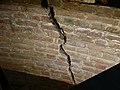
Remains of the city wall in Haus Altenwall 9

Remnants of the city wall in the 400-year-old warehouse in Schnoor

Foundation Langenstrasse 72
Foundation "groom"

City wall in 1534


_der_Steffenstadt_NO.jpg)
In addition, the archaeological findings and findings from the excavations during the development of many houses on the Wall up to the Schnoor are secured.
See also
Literature and plans
literature
- Karolin Bubke: The Bremen city wall. Written tradition and archaeological findings from a medieval fortification structure. State Archive Bremen, Bremen 2007, ISBN 978-3-925729-48-5 (publications from the State Archive of the Free Hanseatic City of Bremen, vol. 68).
- Herbert Black Forest : The Great Bremen Lexicon . Edition Temmen, Bremen 2003, ISBN 3-86108-693-X .
- Franz Buchenau : The Free Hanseatic City of Bremen. A local lore . 4 adults Edition, ed. Dietrich Steilen Bremen 1934.
- Wilfried Helling : Village and Domburg as an old Bremen settlement area . In: Der Aufbau , Verlag Wiederaufbau, Bremen 1999.
- Friedrich Prüser : The battles. Bremen's old shore harbor . Publishing house Robert Bargmann, Bremen 1957.
- Manfred Rech: Found Past - Archeology of the Middle Ages in Bremen. Der Landesarchäologe Bremen, Bremen 2004, ISBN 3-7749-3233-6 (created as a companion volume to an exhibition at the Fockemuseum , still available there).
Historical plans with city walls and fortifications
- Hans Weigel († around 1578): Bremen cityscape on the Weser side from 1550/1564
- Franz Hogenberg (1535–1590): Brema plan from 1574 and 1588/89
- Jürgen Landwehr (1580–1646): Oil painting in the town hall from 1602 or 1617
- Matthäus Merian d. Elder (1593–1650): bird's eye view of Bremen from 1640/1641
- Johann Landwehr : City view from a bird's eye view with new town and old town from 1661
- Caspar Schultze (1635–1715): Plan of Bremen from 1664 and 1690
- Johann Daniel Heinbach (1694–1764), city maps from 1734 and 1757
- Carl Ludwig Murtfeldt (1745–1820) and Georg Heinrich Tischbein (1753–1848): Murtfeldtsche map of Bremen from 1796
- Adolf Eltzner (1816–1891): Plan of Bremen from a bird's eye view from the southeast, Leipzig 1851
See also
Individual evidence
- ↑ Manfred Rech : Found Past - Archeology of the Middle Ages in Bremen , p. 86f.
- ↑ Karolin Bubke: Die Bremer Stadtmauer , p. 24, p. 32f.
- ↑ Manfred Rech: Found Past - Archeology of the Middle Ages in Bremen , S. 87f.
- ↑ Manfred Rech: Found Past - Archeology of the Middle Ages in Bremen , pp. 89, 90.
- ↑ Karolin Bubke: Die Bremer Stadtmauer , p. 296.
- ↑ Karolin Bubke: The Bremen city wall . Pp. 89-91.
- ↑ Karolin Bubke: The Bremen city wall . Pp. 92-95.
- ↑ Karolin Bubke: The Bremen city wall . P. 96 f.
- ↑ Karolin Bubke: The Bremen city wall . P. 100.
- ↑ Karolin Bubke: The Bremen city wall . P. 98 f and plan p. 295.
- ↑ Karolin Bubke: The Bremen city wall . P. 103 f.
- ↑ For the farmers who used to live here between Steinweg and Schleifmühle, see Hanna Lampe: The Pagenthorner Bauernschaft . In: Bremisches Jahrbuch 42, 1947, pp. 97–153.
- ↑ http://www.huchting-archiv.de/huchtings-geschichte.html History of Huchtings: restless Ochtum border.
- ↑ Altenwall 18, 24; Am Wall 115-117, 127-134, 166/167, 187/188, 200; Ostertorwallstraße 15, 40/42; Herdentorwallstrasse 2; Spitzenkiel 5–8, Langenstrasse 42/44, 68, 76, Jacobistr. 20; Battle 34/36.
- ↑ http://www.bremen-freizeit.de/bremen/stadt/bauwerk/cnl301-ostertorwache.php www.bremen-freizeit.de: Ostertorwache .
- ↑ http://www.klausdede.de/index.php?content=weserundjade&sub=28 Klaus Dede: Weser and Jade → 1810–1819 → 1814.
- ↑ Hans Dörries (ed.): Bremische Landesvermessung 1790–1798 , plate 6: 'Bremen with the Vorstædten' after the survey by Ing. Cap. Schilling 1772 printed 1795.
- ↑ Karolin Bubke, Die Bremer Stadtmauer , State Archives Bremen, 2007, p. 147
- ^ Dieter Bischop: Excavations in the city area of Bremen. landesarchaeologie.bremen.de, accessed on September 12, 2017 (go to heading “2014: The short guest performance of the Fangturm”).
- ^ Herbert Black Forest: History of the Free Hanseatic City of Bremen . Volume I, p. 520. Edition Temmen, Bremen 1995, ISBN 3-86108-283-7 .
- ↑ Location community Stephani: Street names → Doventor ( Memento from March 25, 2014 in the Internet Archive )