Georg Heinrich Tischbein
Georg Heinrich Tischbein (* 1753 in Marburg , † March 4, 1848 in Bremen ) was a German engraver , etcher , cartographer and mechanic ( engineer in today's sense ).
biography
Tischbein comes from the large artist family Tischbein (father and children see there). He was the second son of Johannes Tischbein, who had been married since 1751 and died in 1757 as a university mechanic in Marburg.
Works
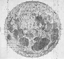
In 1785 Tischbein came to Bremen and from 1789 to 1791 he cut the panels for the Schrötersche Mondwerk . Together with Carl Ludwig Murtfeldt , the Murtfeldt map of Bremen was created in 1796 . Christian Abraham Heineken together with councilor Johann Gildemeister developed the first trigonometric survey of Bremen. In 1798, Tischbein stabbed this Bremen area map, which was reprinted in 1806 taking into account the area expansion of 1803. In 1799 the maps and their views were engraved in Roller's town history .
In 1804, Tischbein engraved the map of the Duchy of Oldenburg drawn by geodesist Christoph Friedrich Mentz in copper.
In addition, he produced numerous pictures and views.
literature
- Herbert Black Forest : The Great Bremen Lexicon . 2nd, updated, revised and expanded edition. Edition Temmen, Bremen 2003, ISBN 3-86108-693-X .
- H. Schumacher: The Lilienthal observatory. A picture from the history of celestial science in Germany. In: Naturwissenschaftlicher Verein zu Bremen (Hrsg.): Treatises of the Naturwissenschaftlicher Verein zu Bremen. Volume 11, p. 167 ( PDF on ZOBODAT ).
Web links
Individual evidence
- ↑ Explanations in the supplement to the Oldenburg single tickets
| personal data | |
|---|---|
| SURNAME | Tischbein, Georg Heinrich |
| BRIEF DESCRIPTION | German engraver and cartographer |
| DATE OF BIRTH | 1753 |
| PLACE OF BIRTH | Marburg |
| DATE OF DEATH | March 4, 1848 |
| Place of death | Bremen |

