Dilich Chronicle

The so-called Dilich Chronicle of 1603/04, named after the draftsman and author Wilhelm Dilich , deals with the topography and history of Bremen .
Emergence
The illustrated city portrait was created in a phase of prosperity before the Thirty Years War and in a time of increased efforts by Bremen to achieve imperial immediacy . In 1596 Dilich had visited Bremen, made topographical drawings here and also had discussions with the council , which he referred to when in 1602 he presented him with two copies of a small Duodez ribbon with the title Urbis Bremae Typus et Chronicon . But the later mayor Heinrich Krefting objected to the text and went to work himself. Above all, he wrote the text of the chronicle from scratch, in which he emphasized Bremen's legal status as a free imperial city outside the sovereignty of the Archdiocese of Bremen. Another change concerned the inclusion of the Bremen rural area in the representation in order to emphasize the urban claim to rule here as well. As an author, however, Krefting wanted to remain anonymous. The structure remained unchanged: the dedication to the Bremen Council is followed by a preface to the reader , in some editions a poem of praise for the city by Hermann Meier (Hermannus Maierus) and then the 291 paginated text pages about the location of the city and its suitability as a trading port , to the cityscape with the buildings as well as the actual chronicle text, all in Latin.
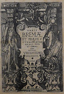
The various prints of the work, enlarged in terms of content, illustrative, cartographical and quarto format from 1603 , which Wilhelm Wessel , who came from Bremen, had under the now expanded title Urbis Bremae et praefecturarum, quas habet, Typus et Chronicon (image and chronicle of the city of Bremen and its Dominions) printed in Kassel are partly dated 1603 and partly 1604 in the dedication, and in 1605 288 copies were sent to Bremen. The text is set in relatively large, clear antiqua letters. The number of illustrations bound between the set pages includes 22 etched maps or cityscapes and two woodcuts. Some copies are provided with bound handwritten chronicle continuations.
Probably from the year 1605, the only copy of the proof has survived in two volumes of a German edition that was not realized as an edition print, but which lacks a chronicle section.
The boards
The pages with letterpress are paginated continuously , the etchings, however, as Roman numbered tabulæ stapled between them. The following list contains all image pages. The links lead to the relevant image in the digitized copy from 1603 in the University Library of Bremen. This way also allows you to page forward or back to the context of the text, the respective "Explicatio", the legend and the explanation. A second link is given to some boards, it usually refers to a single image in Commons with better image quality.
The topographical details at Dilich are considered reliable above average. Most of them were created based on our own drawings on site or in collaboration with Bremen-based template suppliers. The use of the etching technique instead of the copperplate is unusual for maps and views .
Edition of 1602
At least four plates were not included in the editions of 1603/05:
- Plate 6, Delineatio Urbis Bremae Facta (two views, from north and south, probably taken in 1597).
- Plate 7 : Castellum quod est Sponsa ( Brautzwinger on the glory ), seen from the northeast and from the southeast, based on a drawing from 1597. Cf. Plate 18 from 1604.
- Incliti Urbis Bremae Typus (bird's eye view from the southeast). (Not before 1601).
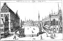
- Delineatio Fori (market based on a drawing from 1596)
Edition from 1603/05
- Plate 1 : (Map of Northern Germany).
- Table 2 : Visurgis accurata descriptio (map of the Lower Weser)
- Table 3 : (Map of the North and Baltic Sea coasts)
- Plate 4 (map in cone projection of Northern Europe)
- Plate 5 (book) and (sheet) : Urbis Bremæ territorium. 1605. (Stadtbremischer land holdings - complete overview)
- Plate 6 (book) : Utriusque Vihlandiæ inferioris et superioris typus (Both, the Nieder- and Obervieland map)
- Plate 7 (book) Hollerlandæ, Blocklandæ, Werderlandæ Præfecturarũ Urbis Bre [mae] typus (map of the urban Bremen rural areas to the right of the Weser and south of the Lesum after a drawing from 1596)
- Table 8 : Præfectura Nienkercke & Blomẽthal (Neuenkirchen and Blumenthal Office)
- Plate 9 : Præfecturæ Bederkesæ typus (Bederkesa Office)
- Plate 10 : Antiquor [um] Saxoniæ populorum sedes (seats of the ancient peoples of Saxony) - Germanic tribes at the time of the Roman Empire based on the map of Germania
- On print page 38 a woodcut by Roland from Bremen has been inserted into the text.
- Plate 11 (book) and (sheet) : Descriptio antiquæ urbis Bremæ circiter MCCC (historical reconstruction of the bird's eye view plan for around 1300). Mistake: The Great Weser Bridge , built before 1244, is not shown. Unclear: the praetorium drawn in the middle of the market.
- Plate 12 : Typus annum circiter MCCC (city view according to Plate 15, but reconstructed for around 1300). Christian von Apen provided preliminary drawings for the traditional costumes (which are more like those of the early 16th century) .
- Plate 13 (book) and (sheet) : Urbis Bremæ typus (bird's eye view from the south, without suburbs, 1603)
- Plate 14 : Urbis Bremæ typus (city map with suburbs, 1603)
- Plate 15 (book) and (sheet) : Delineatio Bremæ (city view from the south-west including the area of the later New Town). 1603. Refined version of Plate 6 from 1602, drawn in 1597, see p. O.
- Plate 16 : Urbis Bremæ Typus (view of the city from the northeast, near the grinding mill)
- Plate 17 (book) and (sheet) Delineatio fori ( market place ).
- Plate 18 Sponsa Castellum ( glory kennel (bride) , based on a drawing from 1596).
- Panel 20 (book) and panel 20 (sheet) : Bederkesa , view of the castle.
- Plate 21 (book) and (sheet) : Leha (Lehe, today Bremerhaven-Lehe )
- On print page 93 , a woodcut from the tomb of Arnd von Gröpelingen is inserted into the text.
- On an unpaginated double page (book) and (excerpt) between p. 230 and 231 is the etching of the battle of Drakenburg , probably based on a copy by Christian von Apen .
literature
expenditure
The Bremen State and University Library , the Bremen State Archives and the Focke Museum have copies from various editions. Only the two volumes from 1605 in German are preserved in the university library in only one copy each.
- Urbis Bremae Typus et chronicon . Autore Wilhelmo Dilichio, Kassel: Wessel, [around 1602]. With 9 etchings, duodec format.
- Urbis Bremae Et Praefecturaru [m], Quas Habet, Type [us] Et Chronicon . Kassel: Wessel, [1603 and 1604]
- First part of the Bremer Chronic from the situ / place or camp / as well as the comforts of the city of Bremen , without place and year [probably Kassel, around 1605], and
- Of the shape and form of the city of Bremen / Also actual description of the same Gebewden Das Ander Theil , Kassel: Wessel [probably Kassel, around 1605].
Secondary literature
- Herbert Schwarzwälder : View of Bremen , Bremen 1985, figs. 10-23 with supplement picture explanations , pp. 3–8.
- Bettina Schleier: Wilhelm Dilich's Bremen Chronicle . In: Bremisches Jahrbuch 73, 1994, pp. 12–47. also digital here .
- Rolf Gramatzki: The frontispiece of the Bremen Chronicle by Wilhelm Dilich . In: Bremisches Jahrbuch 69, 1990, pp. 273–282. (Critical on this: Schleier, note 100).
Individual evidence
- ↑ URBIS BREMAE TYPUS ET CHRONICON · AUTHORS · VVILHELMO DILICHO VVABERANO HASSO · CASSELIS · Per VVilhelmm VVeſſelium · Anno Christi 1602
- ↑ Suntibus Friderici Wilhelmi Meyeri, Varia scripta ad historiam et ivs pvblicvm Imperii germanici ... (Braunschweig 1730), p 954
- ↑ Black Forest: View of Bremen , supplement for explanations of pictures , p. 5.
- ↑ Schwarzwälder: Blick auf Bremen , illus. P. 10, supplement picture explanations , p. 6, nos. 14 and 15 ..
- ↑ Schwarzwälder: Blick auf Bremen , Supplement , picture explanations , p. 7, no. 20 (without illustration).
- ↑ Schwarzwälder: Blick auf Bremen , illus. P. 10, booklet picture explanations , p. 5, no. 10. (without ill.)
- ↑ Schwarzwälder: Blick auf Bremen , Supplement picture explanations , p. 4–5 dates the two maps of the territories to 1605.
- ↑ Sketch and tabular representation in three languages Γερμανίας Μεγάλης θέσις / Germaniae magnae situs of Claudius Ptolemy , but with the wrong localization of Tecelia (in the original at the Weser estuary) and Phabiranum (in the original northeast of the Weser estuary. Bremen was often mentioned as the first mention of Ptolemy )
- ↑ Black Forest: View of Bremen , Supplement, Picture Explanations , p. 5, No. 13.
- ↑ Black Forest: View of Bremen , Supplement, Picture Explanations , p. 6, No. 18.
- ↑ Black Forest: View of Bremen , Supplement, Picture Explanations , p. 5, No. 11.
- ↑ Black Forest: View of Bremen , Supplement, Picture Explanations , p. 5, No. 12.
- ↑ Black Forest: View of Bremen , Supplement, Picture Explanations , p. 6, No. 16.
- ↑ Black Forest: View of Bremen , Supplement picture explanations , p. 6, no. 17.
- ↑ Black Forest: View of Bremen , Supplement, Picture Explanations , p. 7, No. 22 and 23.
- ↑ StUB Bremen, Brem.b.1118.
Web links
A copy from 1603/05 from the State and University Library Bremen is available online:

