Leher Heerstrasse
| Leher Heerstrasse | |
|---|---|
| Street in Bremen | |
| Basic data | |
| city | Bremen |
| district | Horn-Lehe , Lehe |
| Created | 1816/19 |
| Cross streets | Berckstrasse , Riensbergerstr., Am Herzogenkamp, Luisental, Am Brahmkamp, Vorstr., Ledaweg, Brucknerstr ., An der Horner Mühle, Gerold-Janssen- Str., Lilienthaler Heerstraße, Senator Bölkenstr ., Im Leher Feld, Wilhelm-Röntgen- Str., Hinrich-Wriede- Str., Schönauerstr., Sine-Wessels-Str., Nernststr ., Schorf, Rudolf-Tarnow- Str., Am Rüten, Uppe Angst |
| Buildings | Horner Mühle , Landhaus Louisenthal , Villa Leupold |
| use | |
| User groups | Tram, cars, bikes and pedestrians |
| Road design | mostly two- and sometimes four-lane road |
| Technical specifications | |
| Street length | 2700 meters |


The Leher Heerstraße is a historical street in Bremen's district of Horn-Lehe , district Lehe. It leads from the Horner Heerstraße to Oberneulander Heerstraße . It is divided into two sections by Lilienthaler Heerstraße .
The cross streets were named Berckstraße after Hermann Berck (1740-1816), businessman and councilor / senator, Riensbergerstraße after the district of Riensberg , Am Herzogenkamp after the Hertoghe estate family , Luisental after a former country house, Vorstraße, one of the oldest streets, Ledaweg to Leda as the oldest (1187) name form for Lehe, Am Brahmkamp after a hallway ( Kamp ) Brahm = gorse , Im Leher Feld as hallway name, Schönauenstraße, after a hallway, Sine-Wessels-Straße after Sine Wessels (1877-1943), actress of the Low German language, scabs after Good for scab from the 13th century, on Rüten after a corridor designation, a meanness ( common land ) in Oberneuland was Uppe fear as popular name due to a former place of execution; otherwise see the link to the streets.
history
Surname
The Leher Heerstraße was named after the Lehe district, first mentioned in a document in 1185. Lehe stands in general for the Old High German word Lieth ( Lee or Le ), which means something like hill or foothills, which is understood to mean ice-age ridge lines. The name Lehe can also refer to the Low German word Leda (to lead or lead). In Bremen and Umzu, many military roads were built after 1800 or roads were named as military roads (see Bremen streets ).
development
Lehe was known as a village from the 12th century and still belonged to the Vogtei Langwedel , then to Goh Hollerland . The Schorf ( Scorwe ) estate was mentioned in 1229. The last execution took place in 1698 at the medieval execution site at the cross street Uppe Angst .
Until the middle of the 19th century, the road and the surrounding area were still characterized by the farms and the estates.
From 1811 to 1815, Lehe (≈300 inhabitants) received municipal independence for the first time during the French occupation as part of the Mairie Borgfeld .
In the 19th century, around 1816-1819, the Leher Heerstraße was paved and expanded as a military road.
In 1855 Horn-Lehe had 805 inhabitants (2009: 8212 inhabitants).
In 1871/1888 Horn and Lehe were merged and in 1921 Horn and the southern parts of Lehe were incorporated into Bremen.
By 1974, the Oberpostdirektion built a vocational training center on Leher Heerstrasse. Today (2017) there are residential buildings and a shopping center on the site, accessed through the new Gerold-Janssen-Strasse and Paul-Großmann-Strasse.
traffic
Line 4 of the Bremen tram has been running on the street since 1998, which branches off further north on Lilienthaler Heerstraße at the Leh roundabout, which was converted into an intersection with an integrated railway turning loop.
The full length of the street is used by bus routes 33 and 34.
Bus lines 630 (to Lilienthal, Zeven and Heeslingen ) and 670 (to Worpswede ) go to the surrounding area .
Buildings and facilities
On Leher Heerstraße there are one to four-story buildings, which are mostly residential buildings, and in the central areas there are commercial buildings.
- No. 16: Single- storey country house Haus Bätjer built for Albert Bätjer from 1904 according to plans by Hugo Wagner in reform style
- No. 98: Horner Mühle , gallery Dutch windmill from 1849
- No. 105: two-storey classicist country house Louisenthal (also Landhaus Möller ) from around 1815 built for Mayor Georg Gröning , Hornlehe local office since 2014
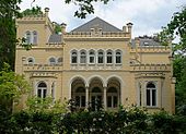
- No. 194: two- and three-storey historicized residential building Villa Leupold with central projection from 1872 built for the merchant consul Hermann Leupold according to plans by Johann Georg Poppe ; 1903/1908 named as Villa Eichenhorst.
Other buildings and facilities worth mentioning
- Railway bridge on the Bremen-Hamburg line
- No. 17/21: three- and four-storey residential complex Horn-Lehe (student residence)
- Corner of Vorstraße / Ledaweg: Catholic St. Georg parish from 1959 based on plans by Ludger Sunder-Plassmann.
- No. 23: After 1919, the residence of Vice-Admiral of the Imperial Navy Wilhelm Souchon , who was Commander-in-Chief of the Ottoman Navy and the Bulgarian Navy from 1914 to 1917 . Today: 4-st. Residential and commercial building
- No. 51: Formerly “Lamp Shop” by Henry Grohnfeldt
- No. 66: four-story eye center and office building from the 2000s
- No. 76: two-storey house from 1908; lived here in the 1960s a. a. Karl Haberjahn (1886–19 ??), founder of the Society of Circus Friends
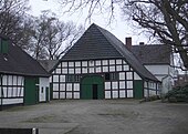
- No. 97/99: single-storey Wedermann farmhouse as a half-timbered building
- No. 107: Former Bölken-Hof of the farmer and Senator Andreas Bölken ; today a shopping center and residential area
- No. 110: three-storey residential building
- No. 111: eight-storey high-rise residential complex, in front of which was the Senator-Bölken-Hof, which is reminiscent of a restaurant (e).
- No. 115/117: eight-story high-rise residential complex
- Motorway bridge on the A 27 motorway Cuxhaven - Walsrode motorway triangle
- Corner of Wilhelm-Röntgen-Straße: two-story shopping center
- No. 125: A two-story half-timbered house stood here, demolished in 1996.
- No. 127: The home of the sculptor Ernst Gorsemann used to stand here .
- No. 139: one-storey service center with u. a. the Johanniterhaus Bremen
- No. 140: one and two-storey Hotel Landgut Horn
- No. 182: two-storey residential building
Monuments, plaques
- No. 127: Here was or is (?) A duplicate of Ernst Gorsemann's Berlin bear ; the original has been in the Bremer Wallanlagen since 1955
-
Stumbling blocks for the victims of National Socialism according to the list of stumbling blocks in Bremen :
- No. 227: for Charles Hofrichter (1867–1943), murdered
See also
literature
- Herbert Black Forest : The Great Bremen Lexicon . 2nd, expanded and updated edition. In two volumes. Edition Temmen, Bremen 2003, ISBN 3-86108-693-X (first edition: 2002, supplementary volume A – Z. 2008, ISBN 978-3-86108-986-5 )
- Monika Porsch: Bremer Straßenlexikon , complete edition. Schünemann, Bremen 2003, ISBN 3-7961-1850-X .
- Michael Koppel: Horn-Lehe-Lexikon . Edition Temmen , Bremen 2012, ISBN 978-3-8378-1029-5 .
- Parish Horn, local office and civil association Horn-Lehe (Ed.): 800 years of Horn-Lehe . Bremen 1985.
Individual evidence
- ↑ Weser-Kurier of June 22, 1974: The “Poststadt” in Horn is neatly nested from the air
Web links
Coordinates: 53 ° 6 ′ 3 ″ N , 8 ° 52 ′ 57 ″ E


