Mayor-Smidt-Strasse
| Mayor-Smidt-Strasse | |
|---|---|
| Street in Bremen | |
| Basic data | |
| city | Bremen |
| Districts | Old town , station suburb |
| Created | Street from the 18th / 19th century Century |
| Cross streets | At the Handelsmuseum, Hugo-Schauinsland-Platz, Breiten Weg , Falkenstraße, Birkenstraße, Am Wandrahm, Contrescarpe , Am Wall , Ansgaritorstraße, Jacobistraße, Wandschneiderstraße, Hutfilterstraße , Am Brill , Martinistraße , Langenstraße , Schlachte |
| Buildings | Übersee-Museum , Sparkasse Bremen , Brillissimo, Bettenhaus Wührmann, Zurich House, Pension House |
| use | |
| User groups | Cars, trams, bicycles and pedestrians |
| Road design | four-lane road, two tram tracks |
| Technical specifications | |
| Street length | 950 meters |
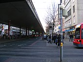
The Bürgermeister-Smidt-Straße is a historical street in Bremen in north-south direction. It leads from the main train station to the Bürgermeister-Smidt-Brücke over the Weser and to Langemarckstrasse in Bremer-Neustadt .
The cross streets were u. a. Named as Beim Handelsmuseum after the name of the Übersee-Museum at the time , Hugo-Schauinsland -Platz after the founder of the Überseemuseum from 1896, Breiten Weg after a broad way, Falkenstraße after the bird of prey, Birkenstraße after the tree, Am Wandrahm after the frames set up there der Färber , Contrescarpe to the wall side = scarpe opposite = contre the city, Am Wall after the city wall , Ansgaritorstraße after the gate that led to the Ansgariikirche , Jacobistraße after the former Jakobikirche , Wandschneiderstraße after the local tailors , Hutfilterstraße , Am Brill after one small opening in the Bremen city wall , Martinistraße after the Martinikirche , Langenstraße (1234 the longa platea ) due to its length and Schlachte after slagt , the driving in of the bank posts.
history

Surname
The street was named in 1945 after Bremen's famous mayor Johann Smidt (1773-1857), the founder of Bremerhaven . Before that, there was a street with the same name in Bremen - Schwachhausen (today Carl-Schurz-Straße) since 1890 .
In the old town (Weser to Wallanlagen) the street was called Kaiserstraße since 1875 and in the northern area (Wallanlage to the train station) since the middle of the 19th century Georgstraße. From 1938 to 1945 the Kaiserstrasse was called General- Ludendorff- Strasse .
development
Fortification
In the Middle Ages, a city wall surrounded Bremen's old town on the land side . From 1601 this became the Bremen fortification system . In the Dillich plan from 1603, a wide street crosses the old town from the Weser to the ramparts, closed by a gate, a bastion and the moat. In Murtfeldt -Plan of 1796 another road routing is shown. From the Brill there is only a smaller street to Jacobistraße. The expanded Ansgarii bastion can be reached via Öhlmühlenstraße.
From 1802 to 1811 the fortifications were removed and the Bremen ramparts were built. The city expanded to the north. In 1847 the first station in Bremen came for the Hanover State Railway, west of the later main station. Georgstraße (today the northern part of Bürgermeister-Smidt-Straße) was built between the train station and the ramparts / Ansgariitor.
From 1873 to 1875 a direct route was built from the Hanover station (later the Bremen main station next to it ) over the newly laid out Kaiserstraße to the new Kaiser bridge over the Weser in the direction of Neustadt. Several streets and many houses had to give way for this road breakthrough that separated the old town, including the old Seefahrt house from 1663 in 1874. A little west of the earlier Glockenstrasse, the new street met the Weser. The area at Am Brill and Behind the Brill was still confusing.
In 1881 the Ringbahn Nordstraße - Markt - Am Dobben - Bahnhof - Kaiserstraße was built on by the Great Bremen Horse Railway. In 1900 the horse tram was electrified from the Bremen tram .
In 1902, for traffic-related reasons, Patz Am Brill was expanded as a junction between Kaiserstraße , Hutfilterstraße and Am Neuen Weg / Faulenstraße . Multi-storey residential and commercial buildings were built on Kaiserstraße / Am Brill.
In 1944 , due to the severe destruction in World War II , only a few older buildings remained.
Reconstruction : The new Bürgermeister-Smidt-Brücke was inaugurated in 1952 , designed according to plans by Friedrich Schumacher and Fritz Brandt.
In 1953, the Martinidurchbruch was created as a new road between Am Brill and the Great Weser Bridge .
In 1960, according to Max Säum's ideas, an eleven-story skyscraper is to be built at the current location of the Brillissimo; but it was not realized. Instead, the 4-tier came in 1964. Department store. A plan from 1971 for a 13-storey high-rise office building for Bremer Treuhand on the Weser between Langenstrasse and Schlachte was not carried out either; instead, a nine-storey commercial building much later.
The roundabout at the Am Wall / Ansgaritor intersection, also known locally as the “turbine intersection”, was heavily congested. Therefore, a so-called fly-over was created in 1972 , a road bridge in the direction of travel to the street Am Wall, co-financed by Horten , which at that time built its department store in the center.
The Bürgermeister-Smidt-Straße is used today (as of 2016) by the Bremen tram lines 1 and 8 (north-south) as well as a short distance by the line 10 (east-west).
Buildings and facilities
Worth mentioning at the Bürgermeister-Smidt-Straße are u. a .:
- Corner at the trade museum: 3-storey. Übersee-Museum from 1896 based on plans by chief building director Franzius , Beermann und Flügel ; the commercial bank was also located here.
- Corner of Breitenweg: 3-storey. Multiplex cinema Übermaxx from 1998. Previously, the Bremen City and State Library from 1897 based on plans by Johann Georg Poppe , which was partially destroyed in 1944, was used as a library until 1975 and as a warehouse for the Überseemuseum until the mid-1990s.
- Corner of Breitenweg: 4-storey. Fruchthof Bremen / House Atlanta from 1955 based on plans by Wortmann and Schott.
- No. 27, corner of Breitenweg No. 32: 8-gesch. BP house with gas station from 1955 according to plans by Zill and 5-storied. Friedrich Schröder's office building.
- No. 16–82 and 27–61 From Breitenweg to Wallanlage: 4 to 6-storey. Residential and commercial buildings
- No. 55/61 corner wall frame: 4-ply Hinrichs & Co. office building from 1955 based on plans by HW Behrens
- No. 63: 5-storey, privately operated multi-storey car park on Wall from 1968 for around 500 parking spaces according to plans by Schott
- No. 69 / corner Contrescarpe: 12-gesch. High-rise residential building from around 1973 based on plans by Morschel
- No. 88: The Ansgarii gatehouse at the earlier Ansgarii gate was restored in 1960 and is a listed building.
- The Bremen ramparts separate the northern and southern parts of the street.
- No. 95 / corner Am Wall 103: 5- and 7-layered AOK office building from 1958 based on plans by Martin Zill and Eberhard Kaiser.
- No.: Multi-storey car park on Brill der Brepark for 950 parking spaces
- No. 118: 5/6 cut. Expansion of the savings bank from 1980 according to plans by Müller-Menckens , previously the old customs office had to be demolished in 1973.
- No. 116: 3-sch. Headquarters of the Sparkasse Bremen from 1906 as a historicizing building according to plans by Martens (Berlin)
- Corner of Hutfizerstraße: This is where the Adler pharmacy, destroyed in 1944, was located in a house from 1910 based on plans by August Abbehusen and Otto Blendermann
- Am Brill, corner of Hutfilterstrasse:
- two 2- and 3-tier modest corner houses from after 1875 on Hutfilterstrasse
- two 4-tier magnificent, historicizing commercial buildings, now on Kaiserstrasse, one of which was demolished in 1928.
- southern 6-stor. Corner house from after 1928, DeFaKa department store since 1933 , destroyed in 1942.
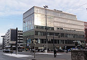
- 7-sch. Investment BRILLissimo of 2010, designed by Green Cloth Ernst (Berlin)
- No. 116/118: 7-gesch. Commercial building
- Am Brill 2: 6/7 cut. Wührmann bed house from 1886 and extension from the 1980s
- Corner of Langenstrasse: 4-storey. Dreikaiserhaus from 1890 in the style of historicism based on plans by Friedrich Wilhelm Rauschenberg . On the facade were the eponymous stone figures of the three Emperors Wilhelm I, Friedrich III. and Wilhelm II of the German Empire. The Richard Siegler restaurant was on the ground floor. The house has not been preserved.
- No. 126–128, corner Langenstraße / Martinistraße: 6-gesch. Zurich House (offices) from 1995 based on plans by Gert Schulze
- Corner of Schlachte No. 32: 7-gesch. Provision house (offices) on the Weser from 1964 based on plans by Hanns Dustmann (Düsseldorf)
- Corner of Langenstrasse No. 71: 9-gesch. Commercial building on the Weser
The buildings Übersee-Museum , the Fruchthof and the Ansgarii-Tor are listed under Bremen monument protection .
17 Bremer Stolpersteine are located in the street (No. 27, 29, 40, 55, 57, 126 and the multi-storey car park) for murdered and fled Jewish citizens and other persecuted people.
See also
literature
- Eberhard Syring: Bremen and its buildings - 1950 - 1979 . Schünemann Verlag, Bremen 2014, ISBN 978-3-944552-30-9 .
- Karolin Bubke: The Bremen city wall. Written tradition and archaeological findings from a medieval fortification structure. Bremen State Archive, Bremen 2007, ISBN 978-3-925729-48-5 .
- Hans Hermann Meyer: The Bremen old town . Edition Temmen , Bremen 2003, ISBN 3-86108-686-7 .
- Herbert Black Forest : View of Bremen. Views - Vogelschauen - City maps from the 16th to 19th centuries , Edition Temmen, Bremen 2006, ISBN 3-7961-1759-7 .
Individual evidence
- ↑ Orientation plan of the free Hanseatic city of Bremen from 1865
- ^ Plan in Meyers Konversations-Lexikon from 1885
- ↑ Architectural guide Bremen: BP-Haus b.zb: 368
- ↑ Architectural guide Bremen: AOK administration building e.g. 303
- ↑ Adler pharmacy, corner of Hutfilter and Kaiserstraße in Bremen . In: Architektonische Rundschau 27, Bremen 1911, pp. 66–67.
- ↑ In: Die Bremer Altstadt , p. 170.
- ↑ In: Die Bremer Altstadt , p. 171.
Coordinates: 53 ° 4 ′ 49 ″ N , 8 ° 48 ′ 14 ″ E


