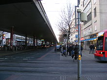
Breitenweg high road
The Breitenweg elevated road in Bremen is an inner-city elevated road that was built over the existing Breitenweg in 1968 as part of the Bremen traffic planning. The aim was to relieve ground-level car traffic in the area of the heavily frequented station forecourt .
location
The Breitenweg high street is 689 meters long in the Mitte district of Bremen above the old Breitenweg between the Fruchthof and the Tivoli high-rise . Under the continuous four-lane street between the lanes of the old Breitenweg there are bicycle and motorcycle parking spaces, parking spaces for cars and taxi parking spaces, all of which are covered by the elevated road. It is signposted as a motor road and is therefore closed to cyclists and pedestrians. The Breitenweg is part of the Bremen ring road system and merges in a westerly direction into Utbremer Strasse and in an easterly direction into Rembertiring. The Bremen main train station , the Überseemuseum and numerous cultural institutions in the area of the freight station are in the immediate vicinity . The Breitenweg high road extends over three postcode areas.
history
The Breitenweg itself was planned in the middle of the 19th century. In the course of industrialization and the emergence of rail traffic, a particularly wide street was to be laid out near the train station - the Breite Weg . The Breitenwegbad , a very popular public bath with a men's swimming pool, medicinal baths and showers, opened in 1877 and existed until 1952. The Fruchthof Bremen was built in 1955 on Breitenweg 29–33 and replaced the first fruit farm from 1908, which was destroyed in the war and which had also stood on Breitenweg.
At the beginning of the 1960s, the multi-lane Breitenweg became too narrow for the increased volume of traffic, and the planners decided on an American elevated road in order to be able to continue to lead the regional regional traffic from Federal Highway 6 and Federal Highway 75 through the city center. In March 1968, the elevated road was built on 54 thin steel pillars in cast concrete. Except for the intermediate piece above the tram route, the casing was cast in one piece.
The opening took place on August 8, 1969. Since then, the Breitenweg high road has been used by around 25,000 vehicles every day. As part of the Bremen Challenge 2013 and other major events, the road was closed to traffic and visited by many thousands of pedestrians.
criticism
As with other inner-city elevated roads, there was occasionally strong aesthetic criticism of the Breitenweg elevated road. The Breitenweg would become a dark, separating and draughty place through the elevated road. In 2013, the CDU Bremen suggested that the elevated road be demolished after it was also used in other large cities , e.g. B. Düsseldorf and Ludwigshafen , elevated roads should be demolished. However, after many protests and rejection, the proposal was not followed up by large parts of the population.
See also
Individual evidence
- ↑ a b Eberhard Syring: Hochstraße without exhilaration. In: wkgeschichte.weser-kurier.de . September 13, 2019, accessed July 14, 2020 .
- ^ Hochstraße Breitenweg in Bremen - street information. In: strassenweb.de . Retrieved July 14, 2020 .
- ↑ Thomas Kuzaj: Between Hochstraße and quality of life. In: Kreiszeitung.de . August 16, 2010, accessed July 14, 2020 .
- ↑ Historical photos of the elevated road. In: weser-kurier.de . April 1, 2014, accessed July 14, 2020 .
- ↑ Wigbert Gerling: Hochstraße should stay. In: weser-kurier.de . April 1, 2014, accessed July 14, 2020 .
Coordinates: 53 ° 4 ′ 57 ″ N , 8 ° 48 ′ 35 ″ E

