
Bremen places
| Bremen places | |
|---|---|
|
|
|
 Bremen market square with the Hanseatic Cross and Schütting |
|
| Basic data | |
| city | Bremen |
| use | |
| User groups | Road traffic, tram , pedestrian traffic , bicycle traffic |
The Bremer courts and the Bremer roads form, as in most cities, the basic structure of the development in the municipality of Bremen .
The most important and oldest square is the Bremen market square . The largest square is the Bürgerweide , where the Bremen Freimarkt takes place in October .
The list of places in Bremen includes all around 80 public places in alphabetical order.
History up to the 13th century
-Braun-Hogenberg.png)
Above / middle: Domshof with cathedral
Below / left: Market place with town hall
above the market: Liebfrauenkirche
right: Domsheide


Bremen was first mentioned in 780. At the highest point of the dune, a wooden church was built around 789 as Bremen's first cathedral . The construction of today's cathedral followed in the 13th century. Around the seat of the Archbishop in the Archdiocese of Bremen grew the place that received market rights in 888 . The market took place on the bank of the Belge and above, probably on the upper surface of today's market square. Bremen spread out from here and from the Domburg . In the early Middle Ages, Bremen developed into a civitas Bremensis with city rights as a Free Imperial City in 1186 . The street network with its squares was created between the Weser and the Bremen city wall from 1229, which initially only included the eastern old town. In the 13th century, Bremen expanded towards the west and now consisted of four parishes .
Most important places
The Bremen market square is with the Bremen town hall , the house of the Bremen citizenship and the house of the merchants, the Schütting , the most important (and oldest) square in Bremen.
At the cathedral and the churches of the four parishes, squares were created:
- The Domshof west of the cathedral belonged partly to the cathedral district and from the 10th century to 1803 it belonged to the diocese of Bremen . It was able to develop as a square when in 1043 a wall (recognizable in the pavement) around the cathedral district was torn down. The market takes place on the square with many banks.
- The Domsheide east of the cathedral was for a long time an insignificant heather area near the Domburg. It only developed into a converted square from the 17th century and is now one of the city's busiest hubs.
- The square of our dear women church yard at the market church St. Veits , which from 1220 on is called Liebfrauenkirche , is u. a. today the flower market.
- The Ansgarikirchhof at the St. Ansgarii Church was a small forecourt of the parish church from 1243, which was removed as a ruin around 1950. The commercial building from 1621 characterizes the square today as well as the Finke high-rise from 1956, the Lloydhof and the Bremer Carrée commercial building .
- At the late Gothic St. Martini Church on the Weser there used to be only a small, walled forecourt.
- On St. Stephani from around 1139 the Stephanikirchhof in today's Stephaniviertel . The Stephaniviertel was not included in the city fortifications until 1307 with the Stadtmure umme sunte Steffens . The place is of little importance.
On the Neustadt side , in the fortified area in 1623, there was a hesitant settlement with a right-angled street network with the market (square) in the Newestatt (today Lucie-Flechtmann-Platz ), the horse market (today Neuer Markt ) and the Green Camp . The fortifications were removed from 1805. The squares lost their importance due to their proximity to the old town.
Transport hubs:
- With the first train stations (1847 and 1889 as well as 1913) the Bremen station square was created . In 2019 the last vacant lots due to the war were closed again. With the Bremen main train station , the transfer station for the Bremen tram and the bus station, it is the most important transport hub for public transport.
- Due to the new train station, the new Kaiserstraße was built by 1875 , which led to the new Kaiserbrücke over the Weser . As part of this road breakthrough separating the old town, several streets had to give way and in 1902, for traffic reasons, the Patz Am Brill was expanded as a junction between Kaiserstraße (today Mayor-Smidt-Straße ), Hutfilterstraße and Am Neuen Weg / Faulenstraße .
- The Domsheide mentioned above is the third traffic junction in public transport. All tram lines pass through one or two of the three squares.
In Vegesack , as the central medium-sized center in Bremen-Nord , there are pedestrian zones and shopping streets
- from the central Sedanplatz from 1895 with the Gustav-Heinemann-Bürgerhaus , the Vegesack market hall and the social administration center north
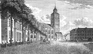
- to Vegesacker Bahnhofsplatz with the train station on the Bremen-Farge – Bremen-Vegesack and Bremen-Burg – Bremen-Vegesack lines from 1862; today served by the regional S-Bahn line RS1 Farge – Bremen – Verden.
In front of the head of the Alte Hafenstrasse there is a small square with restaurants and a view over the Weser and the ferry port, the Utkiek .
Hemelingen was an independent city until 1939 and was then incorporated into the city of Bremen. The former town hall from 1906 and the town hall square Hemelingen from 1902 bear witness to this.
In the Vahr , a young district, the Berliner Freiheit square from around 1960 with the Vahr Citizens' Center from 1977, the shopping center from 2003 and the Aalto high-rise from 1961 is the most important square.
The Wartburgplatz was laid out in Walle in 1874. It lost its importance after 1945, but was thoroughly renovated.
- Important places in Bremen
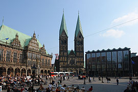
Bremen market square with cathedral , town hall and citizenship
Domshof from 1821 with cathedral and town house

Domsheide with post office and bell

Bahnhofsplatz with main train station from 1889

Town hall square Hemelingen with town hall from 2006 and 1926

Bürgerweide with free market


List of places in Bremen
For the meaning of the names see the linked articles of the known places or the link to the name. However, 18 names with the designation Platz are only streets or paths, so that there are around 80 spaces.
| space | district | District | Function area (m²) |
|---|---|---|---|
| Adelenplatz (from Adelenstiftung) | Obervieland | Habenhausen | path |
| Alfred Ries Square | Eastern suburb | Peterswerder | Away at the Weserstadion |
| At the old sports field | Groepelingen | Oslebshausen | Street |
| At the Brill | center | Old town | Traffic area |
| At the Burgplatz | Burglesum | Burg-Grambke | Street |
| At the Hohentorsplatz | Neustadt | Hohentor | Road at the park |
| At the rest area | Burglesum | Lesum | Street |
| At Schützenplatz | Blumenthal | Farge | Street |
| At the playground | Vegesack | Schönebeck | Path in the countryside |
| At the sports field | Hemelingen | Hemelingen | Street |
| At the sports field (Woltmershausen) | Woltmershausen | Woltmershausen | path |
| At the turning point | Hemelingen | Mahndorf | Street |
| Ansgarikirchhof | center | Old town | Resting place |
| Barnstorfer Platz | Walle | Steffensweg | Way to the green |
| Benque area | Schwachhausen | Bürgerpark | Triangular place to stay |
| Berlin freedom | Vahr | Vahr Southeast | Weekly market |
| Bert-Trautmann- Platz | Groepelingen | Groepelingen | 2014 place in the countryside |
| Groepelinger Library Square | Groepelingen | Lindenhofstrasse | Residence place from 1999 |
| Bi'n Tegelplatz | Hemelingen | Arbergen | Street |
| Ambassador Duckwitz Square | Vegesack | Vegesack | Resting place |
| Bremen station square | center | Station suburb | Front and traffic area, around 4300 m² |
| Bremen market square | center | Old town | Residence and market, around 3000 m² |
| Brommy place | Eastern suburb | Peterswerder | Green area |
| Mayor-Ehlers-Platz | Groepelingen | Lindenhof | Weekly market |
| Bürgerweide (Bremen) | Findorff | Findorff-Bürgerweide | Event (open market) and parking lot, 1000,000 m² |
| Cato Brontjes van Beek Square | Obervieland | Kattenturm | Green area |
| Dieter-Klink- Platz | center | Old town | small resting place |
| Dillichplatz | Blumenthal | Blumenthal | |
| Domsheide | center | Old town | Forecourt and traffic area |
| Domshof | center | Old town | Marketplace, rallies. by 13,000 m² |
| Erlingplatz | Groepelingen | Steffenswg | Path and green area |
| Franz-Löbert-Platz | Huchting | Kirchhuchting | Forecourt to the local office |
| goetheplatz | center | Easter Gate | Theater forecourt |
| Goldbergplatz | Burglesum | Castle dam | Stay, weekly market |
| Grass market | center | Old town | Traffic area |
| Greifswalder Platz | Groepelingen | Ohlenhof | playground |
| Groepelinger Library Square | Groepelingen | Lindenhof | Resting place |
| Grünenkamp | Neustadt | Old New Town | Built up |
| Gustav Pauli Square | Schwachhausen | Schwachhausen | Green area, playground |
| Hanseatenhof | center | Old town | Lounge area, around 2200 m² |
| Heideplatz | Neustadt | Neuenland | Traffic area and green area |
| Helsingborg Square | Burglesum | Castle dam | Traffic area |
| Heinz Hinners Square | Osterholz | Ellener field | small resting place |
| Hillmannplatz | center | Station suburb | Resting place |
| Behind the racing course | Hemelingen | Sebaldsbrück | Street |
| Hohentorsplatz | Neustadt | Old New Town | Resting place |
| Huchtinger village square | Huchting | Kirchhuchting | Resting place |
| Hugo Schauinsland Square | center | Station suburb | Resting place |
| Jacobsplatz | Schwachhausen | Radio Bremen | Road on the green |
| Jenny-Ries-Platz | Blumenthal | Blumenthal | Traffic area |
| Job-Günter-Klink -Platz | Vahr | Garden city of Vahr | Green area |
| Johann-Reiners-Platz | Walle | Überseestadt | |
| Joseph-Haydn- Platz | Schwachhausen | Schwachhausen | Path and courtyard green |
| Kaiser-Friedrich-Platz | Schwachhausen | Barkhof | Resting place |
| Kurt Huebner Square | center | Old town | Kleiner Platz from 2008 (Kalkstraße) |
| Langeooger Platz | Walle | Walle | Green area |
| Leibnizplatz | Neustadt | Old New Town | Traffic area |
| Lesumer Markt (no street name) | Burglesum | Lesum | Weekly market, stay |
| Leutweinplatz | Walle | Walle | Resting place |
| Liegnitzplatz | Groepelingen | Lindenhof | playground |
| Loriotplatz | center | Station suburb | Resting place |
| Lucie-Flechtmann-Platz | Neustadt | Old New Town | Lounge 10,000 m² |
| Ludwig-Franzius- Platz | Walle | Überseestadt | Forecourt at the harbor basin |
| Luise Koch Square | Eastern suburb | Peterswerder | |
| Manfred Fuchs Square | Horn Lehe | Lehe | Forecourt OHB (2018) |
| Osterholz market square | Osterholz | Ellenebrok-Schevemoor | Weekly market Walliser Straße |
| Martini place | center | Old town | St. Martini's forecourt |
| Marwa El Sherbini Square | Eastern suburb | Stone gate | Triangle square |
| New market | Neustadt | Old New Town | Weekly market |
| Peter Zadek Square | Neustadt | Buntentor | Forecourt (2010) Municipal Gallery |
| German Unity Square | center | Station suburb | Space in space |
| Place to the linden tree | - | Borgfeld | Weekly market |
| President Kennedy Square | center | Easter Gate | green forecourt |
| Pusdorf market square | Woltmershausen | Woltmershausen | Weekly market, vernacular: Pusdorf = Woltmershausen |
| Town Hall Square | Hemelingen | Hemelingen | Forecourt |
| Regine-Hildebrandt- Platz | Groepelingen | Oslebshausen | Front and parking lot at the homestead |
| Richard Strauss Square | Schwachhausen | Schwachhausen | green U-shaped playground |
| Ritter-Raschen-Platz | Walle | Walle | Forecourt |
| Rosenplatz | center | Station suburb | Place of the ramparts |
| Rudolf-Hilferding-Platz | center | Station suburb | Forecourt |
| Schillerplatz | Blumenthal | Blumenthal | green triangle square |
| Sedanplatz | Vegesack | Vegesack | Market place with market hall |
| Sengstackeplatz according to polar explorer Captain Heinrich Sengstacke | Walle | Utbremen | green playground |
| At the star | Schwachhausen | Barkhof | Traffic area |
| Tannhäuserplatz | Eastern suburb | Peterswerder | playground |
| Togo Square | Groepelingen | Oslebshausen | Courtyard |
| Treuburger Platz | Blumenthal | Lüssum-Bockhorn | playground |
| Ulrichsplatz | center | Easter Gate | Resting place |
| LiebfrauenkKirchhof | center | Old town | Marketplace |
| Vegesacker Bahnhofsplatz | Vegesack | Vegesack | Forecourt |
| Waller Dorfplatz (not official), at Stiftstrasse | Walle | Walle | Resting place |
| Wartburgplatz | Walle | West end | Resting place |
| Warturm place | Woltmershausen | Woltmershausen | Forecourt |
| Wasenplatz | Burglesum | St. Magnus | Courtyard |
| Wildermuthplatz | Schwachhausen | Radio Bremen | Courtyard |
| Wilhelm-Dehlwes-Platz after the local chronicler | - | Borgfeld | small forecourt of the sports hall |
| Willy-Brandt-Platz | Findorff | Findorff-Bürgerweide | Forecourt |
| Wurtmannplatz | Hemelingen | Hastedt | Place to stay on the Alten Postweg |
| Goat market | Eastern suburb | Stone gate | Resting place |
See also
- Bremen streets
- Huchting: street names and their meaning
- Osterholz: Street names and their meaning
- List of streets and squares in Bremen-Vahr
- Waller districts: streets
swell
- State Statistical Office Bremen: Street directory of the city of Bremen .
- Monika Porsch: Bremer Straßenlexikon , complete edition. Schünemann, Bremen 2003, ISBN 3-7961-1850-X .
- Herbert Black Forest : The Great Bremen Lexicon . Edition Temmen , Bremen 2003, ISBN 3-86108-693-X .
Web links
Individual evidence
- ↑ Orientation plan of the free Hanseatic city of Bremen from 1865
- ^ Plan in Meyers Konversations-Lexikon from 1885