
Yilan Plain

The Yilan Plain ( Chinese 宜蘭 平原 , Pinyin Yilán Píngyuán ) or Lanyang Plain ( Chinese 蘭 陽 平原 ) is a landscape formation in the district of Yilan in the north of the island of Taiwan .
description

|

|
|
|
Central Mountains
|
Xueshan Mountains
|
The plain forms an equilateral triangle with an edge length of 25 to 30 kilometers. At the three corners of this triangle are the places Toucheng (in the north), Sanxing (in the west) and Su'ao (in the south). To the east the plain is bounded by the Pacific, to the north by the Xueshan Mountains and to the south by the foothills of the Central or Chungyang Mountains . In terms of geological history, the plain was created by a depression between the two mountains, which was gradually filled with sediments brought in by rivers. In the past the rivers changed their course at irregular intervals and designed the plain in this way. The plain thus forms an alluvial or alluvial cone . The most important river today is the Lanyang , which is fed by several tributaries in the Central Mountains and the Xueshan Mountains.
Historically, the level was of the indigenous people of the Atayal inhabited. Today the descendants of Han Chinese immigrants make up the majority of the population. The vast majority of the population of Yilan County is concentrated in the Yilan Plain.
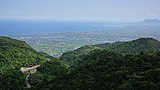
View of the plain from the north

View over the plain to the west ( Guishan Dao island on the horizon )
.jpg)

Individual evidence
- ^ The Inaugural conference of the IGU commission on "Geomorphology and Society": Field Trip Guide. September 15, 2014, accessed December 10, 2017 (English / Chinese).
- ↑ Chih-Hao Hsu, Sao-Jeng Chao, Shuh-Gi Chern, Howard Hwang: Constructing the comprehensive subsurface structure of Lanyang plain . In: Journal of Marine Science and Technology . tape 20 , no. 2 , 2012, p. 195–200 (English, online [PDF]).