Zakynthos (municipality)
|
Zakynthos Municipality Δημοτική Ενότητα Ζακυνθίων (Ζάκυνθος) |
||
|---|---|---|
|
|
||
| Basic data | ||
| State : |
|
|
| Region : |
Ionian islands
|
|
| Regional District : | Zakynthos | |
| Municipality : | Zakynthos | |
| Geographic coordinates : | 37 ° 47 ' N , 20 ° 54' E | |
| Height above d. M .: | 17 m (average) |
|
| Area : | 46.406 km² | |
| Residents : | 16,810 (2011) | |
| Population density : | 362.2 inhabitants / km² | |
| Code No .: | 330101 | |
| Structure: |
3 city districts 3 local communities |
|
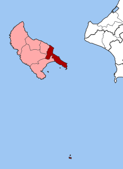
| Location in Zakynthos Municipality and Zakynthos Regional Unit | ||
Zakynthos ( Greek Ζάκυνθος ) is one of six parishes on the Greek island and municipality of Zakynthos . It was founded as a municipality in 1997 and, with the administrative reform in 2010, merged with the other municipal districts to form the new municipality of Zakynthos, which comprises the entire island and some surrounding, uninhabited islets.
location
In addition to the city of Zakynthos and the immediately surrounding villages, the municipality includes the entire Skopos peninsula, which extends to the southeast, up to Cape Gerakas. The Strofades archipelago , which is located 35 km south of the island of Zakynthos in the Ionian Sea, also belongs to the municipality of Zakynthos, as does the uninhabited island of Kalonisi in the bay of Laganas. The highest point of the municipality is the Skopos Hill on the peninsula of the same name with a height of 492 m.
The west coast of the Skopos Peninsula is part of the Zakynthos National Marine Park , which, since its establishment in 1999, has been intended to protect the nesting sites of the sea turtle Caretta caretta . The nesting sites Sekania, Dafni and Gerakas are in the area of the municipality of Zakynthos. All of these nesting sites or nesting beaches are located in the specially protected zone A of the marine national park.
Administrative division
In the course of the municipality reform in 1997 , the previous municipality of Zakynthos, which corresponded to the current municipality, was expanded by five rural municipalities to form the new municipality of Zakynthos. With the administrative reform in 2010 , the six municipalities of the island were merged, which in turn is run as the municipality of Zakynthos. The former parishes formed in 1997 have since had the status of parish districts. The municipality of Zakynthos is subdivided into 3 municipalities and 3 local communities.
| City district / local community |
Greek name | code | Area (km²) | 2001 residents | Residents 2011 | Villages and settlements |
|---|---|---|---|---|---|---|
| Ambelokipi | Δημοτική Κοινότητα Αμπελοκήπων | 33010102 | 7.003 | 1423 | 1930 | Ambelokipi, Kalpaki |
| Gaitani | Δημοτική Κοινότητα Γαϊτανίου | 33010105 | 5.466 | 1411 | 1899 | Gaitani |
| Zakynthos | Δημοτική Κοινότητα Ζακυνθίων | 33010101 | 5.717 | 11,254 | 9733 | Zakynthos, Moni Strofadon (Strofades monastery on the Strofades archipelago ) |
| Argasi | Τοπική Κοινότητα Αργασίου | 33010103 | 7,000 | 771 | 1266 | Argasi, Calliterus |
| Vasilikos | Τοπική Κοινότητα Βασιλικού | 33010104 | 16.508 | 709 | 799 | Vasilikos, Agios Ioannis, Ano Vasilikos, Xirokastello, Kalonisi (uninhabited island) |
| Bochali | Τοπική Κοινότητα Μποχάλης | 33010106 | 4.094 | 907 | 1143 | Bochali, Akrotiri, Kydoni |
| total | 330101 | 45.788 | 16,475 | 16,810 | ||
Individual evidence
- ↑ Results of the 2011 census. ( MS Excel ; 2.6 MB) National Statistical Service of Greece (ΕΛ.ΣΤΑΤ)
- ↑ Law 2539/1997, «Συγκρότηση της Πρωτοβάθμιας Τοπικής Αυτοδιοίκησης." ΦΕΚ 244A / December 4, 1997, Άρθρο 1. Σύσταση δήμων και κοινοτήτων. P. 8801. PDF Online (Greek)
- ↑ Kallikratis Program, Law 3852/2010, «Νέα Αρχιτεκτονική της Αυτοδιοίκησης και της Αποκεντρωμένης ΔιοκεντρωμΠνης Διοίκησης - Πρόγραμημα άρτάτης τρτάτης. ΦΕΚ 87 A / 7.6.2010, Άρθρο 1. Σύσταση δήμων. P. 1788. PDF Online (Greek)

