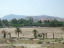
Central Tunisian steppes
The central Tunisian steppes are a landscape in Tunisia that extends from the southern foot regions of the dorsal to the northern edge of the mountain range, which delimits the valley of the Chott el Djerid . In the west the steppe zone borders on the Algerian border and in the east on the narrow Tunisian Sahel zone, which forms the area near the coast.
structure
The zone of the central Tunisian steppes consists of two main areas:
- Steppe highlands ( Haute Steppe )
- Steppe lowlands ( Basse Steppe )
geography
This landscape area consists of a dry highland with grass vegetation, which slopes down to the steppe lowlands with a marginal step (400–600 m) of Cretaceous layer ridges as a transition region to the east.
The areas of the steppe highlands are between 600 and 800 meters. In years with heavy rainfall, its northern area receives quantities of up to 500 mm per year. The south remains largely free of precipitation. Due to its location in the interior of Tunisia, the climate already shows continental characteristics with cold winter months. The landscape is characterized by a grass steppe with half- grass , the vegetation of which increases in a westerly direction. In the past, the nomadic population used the grass to weave everyday objects. With the construction of a railway line to the southern phosphate deposits, the use of grass changed, as it was transported in large quantities for cellulose production.
Only a few wadis cross the highlands and it is only sparsely populated. A few urban settlements are on its fringes. These include Gafsa , Sbeitla , Kasserine , Fériana and Sidi-Bouzid . The partly semi-nomadic population of the rural areas created small grain fields and tree plantings. At the time of the Roman colony, olive trees were grown here . Afforestation has been carried out on the mountain ridges since the 20th century . To this end, Aleppo pine and juniper planted. The streets are partially planted with eucalyptus trees .
The area of the steppe lowlands connects in an easterly direction. Between the layer ridges are small sedimentary basins , the fillings of which come from the Quaternary . The once just as dry area was developed for agricultural use with water systems. The annual rainfall is 150 mm. There are numerous fountains from Roman times in the region.
literature
- Horst Mensching: Tunisia (Scientific Country Customers, Volume 1.), Darmstadt (Scientific Book Society) 1974
Coordinates: 35 ° 5 ' N , 9 ° 9' E


