Zimmerberg (Tabarz)
| Zimmerberg | ||
|---|---|---|
|
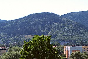
The northern slope of the Zimmerberg |
||
| height | 641.3 m above sea level NN | |
| location | Thuringia , Germany | |
| Mountains | Thuringian Forest | |
| Coordinates | 50 ° 51 '54 " N , 10 ° 31' 12" E | |
|
|
||
| rock | Porphyrite | |
| particularities | First spa promenade | |
The Zimmerberg is a wooded mountain in the area of the municipality of Bad Tabarz in the district of Gotha .
The Zimmerberg has a summit height of 629.7 m above sea level. HN and rises about 200 meters above the foreland in the western part of the Thuringian Forest .
On the western flank of the mountain is the Lauchagrund , on the southern flank a side valley of the Ahrengrund rises, it forms the natural border to the Übelberg to the south.
The Tabarz area offered the medieval old streets a relatively easy climb to the top of the pass on the Kleiner Inselsberg. The Ochsenweg and Schnepfenweg rose on the eastern slope of the Zimmerberg, while the Neue Weg runs on the western flank. When Tabarz developed into a climatic health resort at the end of the 19th century, the Zimmerberg and the neighboring Datenberg were popular excursion destinations for spa guests due to their easy accessibility and panoramic views. The first spa house with a promenade was built here.
Individual evidence
- ↑ Official topographic maps of Thuringia 1: 10,000. Wartburgkreis, district of Gotha, district-free city of Eisenach . In: Thuringian Land Survey Office (Hrsg.): CD-ROM series Top10 . CD 2. Erfurt 1999.
- ↑ Herbert Kürth Friedrichroda, Tabarz, Waltershausen Tourist Wanderatlas by FA Brockhaus, Leipzig, 1976 68 pages

