Zuni-Bandera
| Zuni-Bandera | ||
|---|---|---|
|
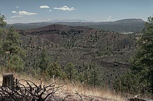
The Bandera crater in the center of the volcanic field |
||
| height | 2550 m | |
| location | New Mexico , USA | |
| Coordinates | 34 ° 48 ′ 0 ″ N , 108 ° 0 ′ 0 ″ W | |
|
|
||
| Type | Volcanic field | |
| rock | basalt | |
| Last eruption | 1170 BC Chr. ± 300 years | |
The Zuni-Bandera - volcanic field is located in Cibola County in the state of New Mexico to the United States of America . It covers an area of 2,460 km² which extends along the Jemez Fault Zone west of the Rio Grande Rift Zone System . It is characterized by its large, extensive lava fields and a large number of cinder cones .
Part of the volcanic field, with the Bandera crater, El Malpais and McCarthy lava field, is covered by the El Malpais National Monument .
geology
Two main activity phases of the volcanic field could be determined. The older was about 3.8 to 3.7 million years ago. The younger started around 1.7 million years ago and continues to this day, creating the extensive lava field known as El Malpais . The youngest part of this lava field is the McCarthy lava field, which extends 60 km to the northeast and has individual lava flows of up to 29 km in length. In the legends of the Indians, the formation of this lava field is described 1,000 years ago. Investigations using the radio-carbon method, however, gave the lava field an age of 3,000 years. The only other activity of the Holocene could be proven at the Bandera crater , which is about nine to ten thousand years old.
Another large lava field is that of Lake Fence , which extends up to 90 km to the west.
source
- Zuni-Bandera in the Global Volcanism Program of the Smithsonian Institution (English)
- Geology of the Zuni Banderas volcanic field

