Diaphragm
| Diaphragm | ||
|---|---|---|
| height | 1341 m above sea level A. | |
| location | Upper Austria , Austria | |
| Mountains | Dead Mountains | |
| Coordinates | 47 ° 39 '52 " N , 13 ° 40' 2" E | |
|
|
||
| rock | Tressenstein lime | |
| Age of the rock | law | |
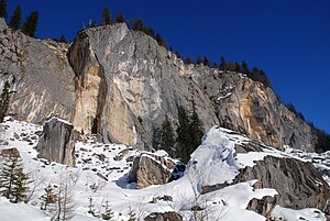
The Zwerchwand is a 1341 m above sea level. A. high mountain in the Dead Mountains near Bad Goisern . The mountain breaks off in a rock face up to 80 m high and about 1 km long towards the south-southwest, from which on October 5, 1978 about 50,000 to 60,000 m³ of rock erupted on the hiking trail 247 below. The path now leads through bizarre rock towers. The large boulders are used as a climbing garden .
Ascent
Climbs:
- Unmarked ascent from the west to the summit
literature
- Gisbert Rabeder: Alpine Club Leader Dead Mountains . For hikers, mountaineers and climbers, Bergverlag Rudolf Rother , June 2005, ISBN 3-7633-1244-7
- Hermann Kohl: Rockslide from the Zwerchwand near the Hütteneck-Alm on October 15, 1978 (= yearbook of the Upper Austrian Museum Association, Society for Regional Studies . No. 124 ). Linz 1979, p. 171–175 ( PDF on ZOBODAT [accessed October 9, 2019]).
Web links
Commons : Zwerchwand - collection of pictures, videos and audio files

