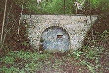
Dahlhausen mining trail

Nacelle of the Hasenwinkel colliery
The Dahlhausen Mining Trail is an approximately ten kilometer long hiking trail through Dahlhausen and Munscheid , which shows relics of mining that took place here from the end of the 17th century to the 1970s at 32 locations .
The hiking trail leads in particular to tunnel mouth holes , shafts , miners ' settlements , heaps and coal paths. The city of Bochum set it up in collaboration with the Bergmann's table Bochum-Süd in the early 1990s . The starting point is the Bochum-Dahlhausen train station . The hiking trail is part of the Route of Industrial Culture and the Ruhr Area Geo-Park.
Breakpoints
- Gallery mouthhole, General 2
- Weitmarer Sattel / Zeche Glocke
- Erbstollenmundloch , General 5
- Kleinzeche Gockel & Niebuhr
- Stollen , Neu-Ruhrort
- Johannes shaft
- Pinge "coal burial hole"
- Civil mining union Neuruhrort
- General coal railway
- Scharpenseel farm
- Tunnel and dump
- Golgotha shaft
- Hof Köllermann
- August tunnel
- Horse stable for pit horses
- "Piärrewiesche"
- Maschinenhaus Tiefbauzeche Hasenwinkel
- Hasenwinkel weather pit
- Brand control of the Hasenwinkel coking plant
- Göpelschacht Theresia
- Primus - jump
- Erbstollen Sunshine
- Tunnel at the "Koalhoapn"
- Hasenwinkel coal way
- Berger shaft
- Briquette factory in Dahlhausen
- Roeder shaft
- Miners' settlement "Am Roederschacht"
- Baaker Mulde tunnel
- Constanz August shaft
- Miners' settlement "Die Burg"
- Bergehalde mine Hasenwinkel
Web links
- Miner's table Bochum-Süd
- Description of all locations on this themed route as part of the Route of Industrial Culture


