Saint-Savin (Isère)
| Saint Savin | ||
|---|---|---|

|
|
|
| region | Auvergne-Rhône-Alpes | |
| Department | Isère | |
| Arrondissement | La Tour-du-Pin | |
| Canton | Bourgoin-Jallieu | |
| Community association | Porte de l'Isère | |
| Coordinates | 45 ° 38 ' N , 5 ° 18' E | |
| height | 213-403 m | |
| surface | 24.55 km 2 | |
| Residents | 4,076 (January 1, 2017) | |
| Population density | 166 inhabitants / km 2 | |
| Post Code | 38300 | |
| INSEE code | 38455 | |
| Website | http://www.mairie-st-savin.fr/ | |
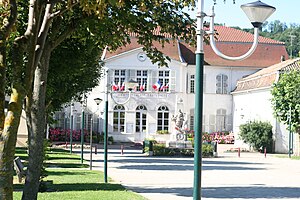
 Saint Savin Town Hall |
||
Saint-Savin is a French municipality with 4076 inhabitants (as of January 1 2017) in the department of Isère in the region Auvergne Rhône-Alpes . Saint-Savin is part of the La Tour-du-Pin arrondissement and the Bourgoin-Jallieu canton . The inhabitants are called Saint-Savinois .
geography
Saint-Savin is surrounded by the neighboring communities of Saint-Chef in the north and north-east, Montcarra in the east, Ruy in the south and south-east, Bourgoin-Jallieu in the south and south-west, Saint-Marcel-Bel-Accueil in the west and Vénérieu in the north-west.
The Ruisseau de Saint-Savin stream , which runs through the municipality, is part of the Canal de Dessèchement de Catelan system , which drains the area. Saint-Savin is located in the Pays des Balmes Dauphinoises wine region .
Population development
| year | 1962 | 1968 | 1975 | 1982 | 1990 | 1999 | 2006 | 2011 |
| Residents | 1,600 | 1,601 | 1,811 | 2.164 | 2,466 | 2,752 | 3,331 | 3,638 |
Attractions
- Castle of Demptézieu with a hexagonal tower from the 15th century, monument historique since 1954
- House from the 16th century with deep relief, monument historique since 1933
- Peythieu fortified house from the 15th century
- Saint Savin Church
Parish partnership
There is a partnership with the Canadian municipality of Verchères in Québec, which was founded by François Jarret from Saint-Savin .

