
Schermützelsee
| Schermützelsee | ||
|---|---|---|

|
||
| Passenger ship Scherri after casting off at Strandbad Buckow pier on the east bank of the lake | ||
| Geographical location | Märkische Schweiz , Brandenburg , Germany | |
| Tributaries | Sophienfliess | |
| Drain | Werderfließ → Buckowsee → Stobber → Friedländer Strom → Alte Oder → Hohensaaten-Friedrichsthaler Wasserstraße → Oder | |
| Places on the shore | Buckow | |
| Data | ||
| Coordinates | 52 ° 34 '4 " N , 14 ° 3' 34" E | |
|
||
| Altitude above sea level | 26.5 m above sea level NHN | |
| surface | 1.37 km² | |
| length | 2170 m | |
| width | 920 m | |
| volume | 22.49 million m³ | |
| scope | 6325 m | |
| Maximum depth | 38.0 m | |
| Middle deep | 16.6 m | |
| PH value | 7.6 | |
| Catchment area | 6264 ha | |
|
particularities |
||

|
||
| Terrain health resort network with a map of the lake | ||

The Schermützelsee is a 137 hectare lake in the Brandenburg district of Märkisch-Oderland . It is the largest lake in Märkische Schweiz and is located in the center of the nature park of the same name, around 50 kilometers east of Berlin . The entire lake area and most of the banks are on the municipal area of the Spa town of Buckow . The name Schermützel goes back to the Slavic settlement period and very likely to the Slavic name for the buckthorn .
history
Detected pile dwellings in the lake, which are attributed to the Lausitz culture , indicate an early settlement of the bank areas. After the East German settlement , the lake belonged to the extensive property of the Cistercian nuns of the Friedland monastery until the middle of the 16th century . Subsequently divided among various landlords, the lake has been owned by the town of Buckow since 1929. Only a strip of the north-west bank below the Bollersdorfer Höhe - described by Fontane and other writers - and the north bank still belong to the neighboring Bollersdorf . With an approximately 7.5-kilometer circular route, some of which runs as a panoramic path high above the lake on the Barnimhang , excursion boats, sailing and the Buckow lido, which opened in 1911, the Schermützelsee plays an important role in tourism in Märkische Schweiz and the health resort Buckow a. Its bathing water quality is classified as excellent according to the bathing water directive of the EC . The former summer house of Bertolt Brechts and Helene Weigels is located on the eastern bank . A museum has been set up in the listed Brecht-Weigel-Haus since 1977, which serves as a memorial for the artist couple and an event location, e.g. for readings.
Hydrology and Ecology
The mesotrophic , stratified body of water is fed by groundwater and the Sophienfließ and drained via the Stobber to the Oder . Its greatest depth reaches 38 meters and is around 12 meters below sea level . The lake lies below the high relief , throated south slope of the Barnim on the western edge of the Buckower Kessel, a basin-like extension of the Vistula- glacial Buckower Rinne or Löcknitz- Stobber-Rinne, which separates the Lebuser Land from the Barnim Plateau . Its catchment area of 6264 hectares consists of around two thirds of arable land and around one third of forest. Designated as a Natura 2000 / FFH area , the Schermützelsee is of great importance for nature and landscape protection in the biotope network of the nature park. The profile of the Federal Agency for Nature Conservation (BfN) emphasizes the pronounced dry erosion valleys, ravine and hillside forests, spring areas and dry grass in the edge area of a strongly relieved compression terminal moraine series. Among the fish of the Schermützelsee that are worthy of protection, the FFH profile lists the bitterling and the loach , both of which are highly endangered according to the Brandenburg Red List . Among the mammals, beavers and otters , which are threatened with extinction, are under protection. As part of the European Bird Protection Area (SPA) Märkische Schweiz for the conservation of wild bird species according to the EU directive , which with 17,968 hectares occupies the largest part of the 20,500 hectare nature park, the water is also the habitat of many endangered bird species.
Affiliation and transport links
The entire lake area belongs to the county town of Buckow, a Kneipp health resort with around 1,600 inhabitants in the center of Märkische Schweiz . The city center stretches along the east bank of the Schermützelsee. The bank areas are also predominantly in the Buckow area. Around half of the north-west bank and part of the north-east bank - a total of roughly from the Grenzkehle to the mouth of the Sophien River, around 200 meters north of the Buckow lido - is located in the Bollersdorf district , a district of the municipality of Oberbarnim .
The district road 6413 leads past the northeast bank and the lido, which connects Buckow to the north between Bollersdorf and Pritzhagen to the state road 34 and to the south-west to the federal road 168 near Waldsieversdorf . In local public transport , the lake can be reached via a bus route operated by Busverkehr Märkisch-Oderland (BMO) with a stop at the lido; the line runs from Strausberg S-Bahn station (station on line S5 of the Berlin S-Bahn network ) via Buckow to Müncheberg station . The same stop goes to the Märkische Schweiz A930 excursion line on the weekend and on public holidays, which also runs from the Strausberg S-Bahn station via Buckow, Pritzhagen, Altfriedland and Neuhardenberg to the Seelow-Gusow train station on the Berlin-Kostrzyn East Railway . Around 800 meters east of the southern tip of the lake is the Buckow station of the Buckower Kleinbahn , which is still operated today as a museum railway as a branch of the Ostbahn to Müncheberg station (separate station section) .
Use, paths and development
With its beach , the excursion boat ride, the water , the hiking trails in some canyon rich forests and the Brecht Weigel House and further the seaside promenade on the trail on the east bank is the Schermützelsee a central part of kurörtlichen infrastructure and the natural park tourism , the cultural tourism and leisure activities in Buckow.
Buckow lido
The Buckow lido on the northeastern bank of the lake was built in 1911. The so-called Fuhrmann Chronicle from 1928 reports:
“And now came the third difficulty, the preparation of the square. For years the latter was used to dump rubbish and rubble. But here they soon created new soil with sand, which was available in excessive quantities in the immediate vicinity. The extremely strong growth of pipes was also eliminated, and now the outdoor pool, next to the Wannseebad near Berlin, the first in the entire province of Brandenburg, offered a sight that Buckow can envy so many Baltic Sea baths. Only one thing bothers today is that, according to the government's decision, the whole side of the street had to be closed with an unsightly wooden fence. "
The unsightly wooden fence was dismantled for a long time and today the pool is open to the lake. Its distinctive, generally wooden and no longer operationally safe diving platform was replaced in 2010. To ensure stability, the foundation construction was made of hot-dip galvanized steel. In order to preserve the seaside charm of the old tower, the construction of the new building, which is also wooden, was closely based on the historical model from the 1920s. For structural reasons, the access walkway to the diving platform also had to be renewed. The measure was financed by the European Agricultural Fund for Rural Development , the federal government and the state of Brandenburg. The public outdoor pool also has: around 120 meters long sandy beach, sunbathing lawn, playground, beach café and rowing and pedal boat rentals. Lifeguards are on site and there are toilets and heated changing rooms at the sanitary facilities. There is a pier for the passenger ships right next to the bathroom.

Strandbad Buckow
in April 2011
Boat rental at the lido

The historic diving platform
in 2007
The new design
in 2012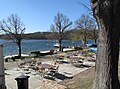
gastronomy

Beach at dusk


Excursion boating and water sports
In addition to the main landing stage at the lido, there are other landing stages at the Fischerkehle restaurant and at Buchenfried on the south-west bank, which passenger ships have not used for a number of years (as of 2013). The excursion boats offer round trips of around one hour and special trips such as moonlight trips or smoking trips as well as the option of complete chartering for groups from the Strandbad pier.
Passenger ship Scherri


Before the German reunification , the Sarja , a ship of Soviet design, sailed on the lake. When negotiations about continued use failed, the owner, VEB Kraftverkehr Fürstenwalde, had the Sarja transported away in 1990. It was replaced in 1992 by the motor ship Scherri owned by a private Buckower family, which runs hourly from the Strandbad from April to October between 10 a.m. and 5 p.m.
The ship was launched in 1879 in the Reiherstieg shipyard in Hamburg as a so-called Alster steamer under the name Reiher with a license for 150 people. Originally from a 50 PS strong steam engine driven, which later became a sailed flush deck converted steamer under constantly changing names ( Saterland, Rhea's Harvestehude Gothmund, Roland ) after his Alster time, the North German and Lower Saxony waters Travelodge , Hamme , Weser , Hunte , Jümme , Leda and Ems . In 1949 he received a 100 hp diesel engine . In 1990 the current skipper bought the badly battered ship, which set out to sea as Scherri in 1992 on the Schermützelsee after an extensive overhaul . The passenger ship of the “Seetours Märkische Schweiz” has space for 70 guests, is 20.95 meters long, 4.38 meters wide and has a load capacity of around 35 tons .
More ships and sailing
In addition to the Scherri, two smaller passenger ships operate on the lake:
- Barge sea eagle . 17 seats (15 below deck, 2 open deck aft ). Year of construction unknown, reconstructed in 1982. 25 HP diesel engine. 9.80 meters long, 2.57 meters wide. Travel times from May to October, every Saturday and Sunday.
- Solar boat Lena Manuela (since 2008). 40 seats. The first electric solar boat on the Schermützelsee can drive close to the shore due to the shallow draft (25 cm when fully occupied). 13 meters long, 3 meters wide.
Apart from the lifeboat of the water rescue service , other motor boats are not allowed on the lake for nature conservation reasons. In order not to damage the bank zones, the boat and jetty regulations stipulate a distance of at least ten meters for the same reasons. Since the 2010s, it has been possible to charter a cutter (original marine cutter K6) with or without a skipper . In sailing , the "Buckower Sailing Club" has been organizing regular yardstick regattas for dinghies since 2006 , which are started using the kangaroo method . In June 2012, for example, twelve boats sailed around the rose cup, which was presented by the queen of the Buckower Rose Days, which lasted several days . In August, nine boats fought for the Buckower Angler's Club trophy. In addition, spring regattas as well as regattas for the fishing festival and at the end of summer are held. No other sailing clubs or water sports associations have formed on the Schermützelsee so far (as of 2012).
Circular route and panorama route


Around the Schermützelsee there is a 7.5 km long hiking trail, which is marked with a green dot. The panorama path forms part of the circular route. It runs in the Barnimhang over the south and south-west bank of the lake from the southern tip of the lake at Buckow to the Grenzkehle. The partly narrow path winds through extensive forests over Buchenfried through several throats (Fischerkehle, Buchenkehle, Grenzkehle), the erosion gorges of Märkische Schweiz. This part of the circular route offers several panoramic views over the lake and is equipped with information boards and numerous seating areas. Its lowest point is at a height of 28, its highest point at 76 meters; a total of 237 meters of ascents and descents have to be mastered. After the descent from the Panoramaweg, the circular route passes, already in the Bollersdorf area, the Langer Grund gorge and several silting and spring moors .
In the further course he touches the children's home “White Dove” and the hotel “Johst am See”, the former “Little White Dove”. Here in 1927 "the mad reporter" Egon Erwin Kisch made a guest appearance . A memorial stone ( boulder ) in Bollersdorf reminds of his daily walks on the Schermützelsee . The circular route, now known as the Egon-Erwin-Kisch-Weg section, leaves the Schwarze Kehle, in which lignite has been mined since 1851 , above it. Here a detour leads to the Bollersdorfer Höhe . However, the plateau is now largely built up or inaccessible to the public, so that from the height there is no longer the view over the lake, which was often described by Fontane in 1863 . Then the path, here part of the Oberbarnimer Feldstein route, circles the northern tip of the lake. Passing the disused holiday homes “Theodor Fontane” and “Haus Tirol”, he reaches the lido again in Buckower area.
Villas on the east bank and Brecht-Weigel-Haus
Another section of the circular route around the lake is the Buckower Straßeenzug Ringstraße / Bertolt-Brecht-Straße with numerous villas from the Wilhelminian era , some of which are in the hilly area high above the east bank and are protected as historical monuments . This includes the Brecht-Weigel-Haus, which has served as a museum and memorial for the artist couple since 1977. Bertolt Brecht and Helene Weigel worked in the summer residence from 1952, Helene Weigel also after Brecht's death in 1956 until her death in 1971. Here, in July / August 1953, Brecht wrote the cycle of poems Buckower Elegien , in which, as in the poem The solution ( Wäre Isn't it easier there, the government dissolved the people and elected another? ), in the poetic reflection of the events of June 17, 1953 , took a clearly distant stance towards the GDR government. With its exhibitions and events such as the annual literary summer with readings, song afternoons, concerts, roundtables and films, the house was presented by the initiative Germany - Land of Ideas as “Selected Location 2006”.
The property and the building ensemble largely got its present appearance after 1910, when the sculptor Georg Roch from Berlin-Schöneberg bought the property. He had the studio house built according to plans by Bruno Möhring , a gable-independent plastered building with a mansard gable roof and elements of the so-called Heimatstyle . Roch's sculptures still adorn the property, which is located directly on the water. As an architectural gem, not only are the buildings under monument protection, but also the lake-side facilities such as the lake balustrade, boat and bathing jetty. The list of monuments leads in detail : Summer residence of Bertolt Brecht and Helene Weigel, consisting of a studio house, chauffeur and gardener's house with side wing and veranda, pavilion over ice cellar and garages, boathouse, water tower and park-like gardens with lake balustrade, bridge, boat and bathing jetty, Garden sculptures, flower garden and street-side property fence . Today (as of 2012) the garden house is inhabited by the daughter of Brechts / Weigels, Barbara Brecht-Schall .

Brecht Weigel House
Sea balustrade of the Brecht Weigel House

Villa on Bertolt-Brecht-Strasse above the east bank

dto.

dto.


Geomorphology, glacial morphology and climate
Buckower Kessel, Buckower Rinne and Barnimhang
The Schermützelsee lies below the Barnimsüdhangs on the western edge of the Buckower Kessel, a basin-like extension of the Stobbertal nature reserve . The valley is part of a glacial meltwater channel that formed in the last two phases of the Vistula Ice Age between the dead ice- filled Oderbruch and the Berlin glacial valley (today's Spreetal) and separates the Barnimplatte from the Lebuser Platte . This approximately 30 kilometers long and two to six kilometers wide Buckower Rinne (also: Löcknitz-Stobber-Rinne ) drains from the low moor and headwaters area Rotes Luch via the Stobber to the northeast to the Oder and via Stobberbach / Löcknitz to the southwest to the Spree . The Urstobber flowed before the formation of the North Sea and Baltic Sea watershed Red Luch from Mohriner Sander Pomeranian ice margin to the southwest over the Oder to Berlin glacial valley. As a result, a counter-rotating tap blade formed from the Oderbruch . The original box valley shape and direction of flow of the Buckower Gully is only preserved from the Buckower Gate , the watershed area in the Rotes Luch headwaters, to the southwest in the short Stobberbach.

While the edge of the Lebus plateau slopes moderately steeply to the Buckower Kessel, the Barnimhang has a high relief in this area for north-east German lowland conditions . It belongs to a compression zone that arose during the Saale-age ice advances through a sometimes strong compression (disturbance) of the older sediments in the Barnim underground between the Freienwalder Heights (also known as the Wriezener Höhe) and the Buckower Kessel, which are still particularly high today . In addition to older ice age deposits, large areas of material from the Tertiary were pressed into the compression moraines. Stratified lower diluvial sands emerge from under the boulder clay of the Barnim surface on the west bank of the Schermützelsee , overlaying tertiary layers: Septarian clay , Stettiner sands, mica sands and lignite with intermediate quartz and molding sands. Especially towards the Schermützelsee, the slope of the plateau takes place in a steeply sloping edge, in which the typical landscape gorges have cut. The gradient from the Krugberg , located around 1.5 kilometers to the northeast - at 129 meters, the highest point in Märkische Schweiz - is around 103 meters to the surface of the lake and around 141 meters to the deepest point of the lake; this deepest bottom of the lake is around 12 meters below sea level .
Formation of the Schermützelsee
According to the current representations, the strains and tensions of the last glaciation and the thawing glaciers in the subsurface of the Buckower Basin left numerous smaller incursions. The lower basins were filled with gradually rising groundwater and formed several lakes, including the Schermützelsee. To the east there are some smaller lakes such as the Griepensee at Buckower Schlosspark and the Buckowsee at the city center, both of which are flowed through by the Stobber, as well as the White Lake , which is only separated by a narrow, swampy strip of land from the southeastern shore of the Schermützelsee. Other depictions trace the formation of the Schermützelsee and other lakes in the Buckower Rinne back to the thawing of blocks of dead ice . After thawing, voids were created in the blocks that had been separated and buried by the glacier ice, which filled with water after their collapse. A water-ecological study by the Technical University of Cottbus , Chair of Water Protection, from 2003 classified the Schermützelsee as a Toteiskesselsee (Toteisaustauhohlform).
Friedrich Solger , professor of geology at Berlin's Friedrich-Wilhelms-Universität in the 1920s, and the archaeologist and local researcher Max Krügel, after analyzing the interglacial deposits, however, came to the conclusion that the Schermützelsee basin must have existed before the last icing . In doing so, they contradicted the view of Felix Wahnschaffe , who viewed the lake as a mighty whirlpool hole, which ice melt water would have created when the last ice receded when it fell out of an ice edge that would have lain idle for a long time at this point and from which the melt water through the Rote Luch would have flowed.
climate
→ See section on climate in the article on Buckow: "Your Majesty, in Buckow the lungs are on velvet"
The Märkische Schweiz nature park is located in the regional climate zone of the subcontinental, dry, southern Mark climate, or broadly classified in the transition area from the Atlantic climate of Western Europe to the continental climate of Eastern Europe. The climate is characterized by cool winters with an average January temperature of −1.2 ° C and relatively warm summers with an average July temperature of 17.8 ° C. In the lowlands, especially in the throats and in the vicinity of the often mist-shrouded lakes, the temperatures are lower and the humidity is high. The rather humid climate in the Buckower Kessel is particularly beneficial for the mixed beech forests. In 2000, the German Weather Service (DWD) certified the spa town as having an ozone-rich climate in a climatic-meteorological report .
Hydrology and limnology
Topography, morphometry, catchment area and water supply
_Scherm%C3%BCtzelsee_(2).JPG)
According to an inventory in 2004, the profile according to the EC Water Framework Directive (EC WFD) for the Schermützelsee (water body no. 8000169622491) indicates an area of 137 hectares. The lake volume is 22,485,206 m³. According to the profile, the maximum depth is 38 meters, but in various other representations it is estimated at up to 48 meters; the nature park administration mentions 45 meters. The great depth and the high depth gradient of F = 5.8 indicate a stable stratification of the water. The theoretical epilimnion depth (Z epi ) in 2001 was 6.6 meters. The longest length of the stretched from north to south, slightly curved and kinking to the northeast is around 2170 and the greatest width around 920 meters. The bank development coefficient (U E ) of 1.7 indicates a strong interlocking of the lake with its surrounding area. The structure of the bay-rich, steeply sloping bank is characterized as natural / near-natural in the bathing water profile .
The surface catchment area of 6264 hectares consists of 67% arable land, 30% forest and 1% pasture. The remaining shares are accounted for by the bank margins, sealed areas (streets, residential areas) as well as ports and berths. The lake is fed by groundwater and the Sophien river. The discharge takes place via the Werderfließ and the Buckowsee in the Stobber zur Oder. The Sophienfließ forms the main inflow with an annual outflow of 3.5 million m³ (annual average from 1977 to 1984); the discharge into the Werder river was determined to be 6.0 million m³ (annual series from 1983 to 1992), so that the probable groundwater supply is around 2.5 million m³ per year. The groundwater catchment area covers 2650 hectares. The renewal time or theoretical residence time (t R ) of the water (filling time) is 2.9 years.
Chemical and trophic characteristics
The anthropogenic influences on the eutrophication of the lake are comparatively small. The lake primarily draws nutrient inputs from the Buckows and the Sophien river near the shore. During the GDR era , the Bollersdorf nursery of LPG Prötzel had been operating deep water extraction from the northern lake basin for irrigation since 1980; the delivery rate was 744 m³ / d (per day). The introduction of pollutants from agriculture, such as at Lake Parstein, or an oversupply of nutrients from fish farms and extensive water withdrawals by the Industrial Fattening Combine (KIM), such as at the Großer Seddiner See , did not take place at the Schermützelsee.
A documentation of the TU Cottbus , Chair for Water Protection , developed in 2004 on behalf of the Federal Environment Agency , identified the lake as mesotrophic (Trophy level II). The data revealed oligotrophy (trophic level I) as a potentially natural reference state of trophies . In 1995 the alkalinity was 3.4 mmol / l , the total hardness 13.0 ° dH (German degrees of hardness ). The conductivity measured near the surface was an annual mean of 447 µS / cm (microSiemens per centimeter) and the mean total nitrogen concentration was 0.7 mg / l in 1995 . In the summer of 1995 the epilimnic nitrate nitrogen concentrations fluctuated between 0.41 µg / l and 0.47 µg / l and the corresponding ammonium nitrogen values (NH 4 -N) between 0.11 µg / l and 0.32 µg / l. The total phosphorus concentration rose on an annual mean from 55 µg / l in 1992 to 92 µg / l in 1995, the value of the spring circulation in 1995 reached 18 µg / l. The chlorophyll a concentration halved between 1992 and 1995 to 3.26 µg / l. The oxygen consumption rate was determined in June 1993 to be 0.067 mg / (cm² d) and in August 1993 to be 0.071 mg / (cm² d). The oxygen concentrations reached the end of June to a depth of 20 meters or about 5 mg / l; in July anaerobia occurred in the deepest sea areas , which in September / October extended to a depth of 15 meters.
Water profile according to the EU Water Framework Directive
The profile according to the EU Water Framework Directive indicated the LAWA trophy index (five-point scale) according to measurements in 2009 as one (= environmental goal of 'very good status' of the WFD is achieved ). The trophic index according to LAWA (1999) summarizes four trophic parameters (TP during the spring full circulation as well as the vegetation means of chlorophyll a , visibility depth and TP ) in one number. The individual parameters are weighted differently. The phosphorus concentration is given with two (= environmental target “good status” of the WFD is achieved ) and the quality component phytoplankton with one. The summarized quality component macrophytes / diatoms received a two, of which macrophytes accounted for a three (= environmental target of the WFD is just missed, […] moderate condition ) and for the diatoms, which are more highly weighted in the overall assessment, a two. The chemical status and the ecological status are rated with two, resulting in an overall rating (overall status) of two. This classification corresponds to the mesotrophic state according to the trophic system . The body of water is characterized as a lime-rich, stratified lake with a relatively large catchment area ( residence time > 30d), type 10 .
Water quality according to the EU Bathing Water Directive
The state office for the environment, health and consumer protection (LUGV) rated the bathing water quality as excellent for the period 2008 to 2011 according to the bathing water directive of the EC . Both the guide values and the limit values were complied with annually during sampling at the lido. The two indicators for faecal pollution of bathing water averaged 2008 to 2011
- for Escherichia coli (limit 1800/100 ml) measured values of 82 per 100 ml for the 95th percentile and of 77 per 100 ml for the 90th percentile and
- for intestinal enterococci (limit value 700/100 ml) readings of 47 per 100 ml for the 95th percentile and of 32 per 100 ml for the 90th percentile.
The water temperature, measured 30 cm below the surface of the water, fluctuated between 14.3 ° C and 23.0 ° C in 2009 and averaged 19.6 ° C. The pH ranged between 7.50 and 8.00 and averaged 7.6. Values between 3.5 meters and 1.8 meters, on average 2.5 meters, were determined for transparency ( depth of view ). The salinity (conversion from conductivity ) is given as fresh water: <0.5 ‰ . As in the water profile, the ecological status is rated with two. The measurement results match the results from 2006, which also did not give rise to any complaints .
Ecology, nature conservation, flora and fauna
Compared to other lakes in the Märkische Schweiz Nature Park, the only moderately polluted, nutrient-poor body of water with its relatively good water quality and relatively high visibility is of great importance for nature and landscape protection in the Nature Park. In the biotope network of the nature park, the lake forms an important link to the Stobber, which flows through the nature park from the Roten Luch over the Buckower Kessel to the Altfriedland ponds . In addition, the Sophienfließ, which drains the north-west of the nature park, flows into the Schermützelsee. According to the nature park administration, the emergence of the tench in the Schermützelsee, which has been caught again since 1991 and which is typical for the Oderbruch, underlines the effectiveness of the efforts to restore the biotope network in the nature park.
Natura 2000, FFH area Schermützelsee
The Schermützelsee is part of the coherent European ecological network of special protection areas Natura 2000 . Among the nine FFH areas of the Märkische Schweiz nature park for the conservation of natural habitats as well as wild animals and plants, it is designated as the FFH area “Schermützelsee”. The profile of the Federal Agency for Nature Conservation (BfN) contains the following description for the 363 hectare area under number 3450-307:
"Richly structured complex with the mesotrophic-alkaline , up to 45 m deep Schermützelsee, pronounced dry erosion valleys, canyon and hillside forests, spring areas and dry grass at the edge of a strongly relief-shaped terminal moraine series."
Phytoplankton and zooplankton

The biovolume of phytoplankton (plant plankton), the basis of the autochthonous food pyramid of a lake, was 0.2 mm³ / l in spring 1993 and below 1 mm³ / l in summer 1993. With a share of 67%, Synedra from the genus of the primary producer was dominated by diatoms . Summer phytoplankton was determined to be over 50% of the total biovolume (GBV) of dinoflagellates with the class Dinophyceae (mainly Ceratium and Peridinium ). In addition, the occurrence of cyanobacteria (blue-green algae) with Microcystis ( Microcystis incerta ) as well as Cryptophyceae and golden algae increased during this period . In 2001 the volume of phytoplankton reached its annual high in April with 2.1 mm³ / l, decreased in June to 1.2 mm³ / l and in the months of July to September to 0.4 mm³ / l. While in April 2001 the diatom species Tabellaria fenestrata dominated the GBV with a share of 84%, it also remained dominant in June, although its share sank to 46% and was supplemented by the dinoflagellate Ceratium hirundinella with 34%, which was then added to the From July to October with GBV proportions between 40 and 50% the only dominant species remained. In July, the species Asterionella formosa and the low-light specialist Cryptomonas sp. and in September Rhodomonas spp. and the ornamental alga Cosmarium sp. Overall, the Ministry for the Environment, Health and Consumer Protection (MUGV) assesses the plant plankton of the Schermützelsee as rich in species , but of low density.
The biomass concentration of the zooplankton in the spring sample in March 1995 was 0.7 mg TG / l ( dry matter content ) and in August 18 mg TG / l. In both growing seasons , calanoid copepods made up the majority , with 73% in spring and 42% in summer. In March another 19% was accounted for by cyclopoid copepods, and isolated daphnia (water fleas) were detected. Herbivorous rotifers at that time consisted mainly of Filina , Polyarthra , Keratella cochlearis , Keratella quadrata and Synchaeta . In August, set with 36% the second largest share of biomass Phyllopoda extending to 26% of Daphnia, 5% of Bosmina and 4% from Diaphanosoma (all from the class of branchiopoda together sat). The proportion of herbivorous rotifers fell below 3% in summer, with Keratella cochlearis reaching greater abundances .
Submersed flora, reeds and other plant communities

The submersed flora determine diving corridors, which are often formed by well moss, which occurs in a water depth of up to 18 meters. The corridors of the filamentous spawning herb , which is more likely to be found in the Alps and in the foothills of the Alps and is rare east of the Elbe, are astonishing . The corridors are supplemented by ground lawns with lawn carpets made of candelabrum algae ( Characeae ). These include societies of the endangered star candlestick alga ( Nitellopsidetum obtusae ), stiff-haired candelabrum alga ( Chara hispida ) as well as Nitellion flexilis , formed from societies of fragile candelabrum and flexible luster alga ( Nitella flexilis ). In the depth range of one to three meters there are stocks of the eared thousand-leaf - the occurrences in this area correlate with the trophy level II of the lake.
Due to the steeply sloping banks, the reed belt is overall only narrow. However, on parts of the warmer east bank and especially on the flatter southern banks, the reed stands and floating leaf communities reach an extension of over a hundred meters. In the period from March 15th to September 15th, the reeds may not be cut back. Outside of the vegetation period, i.e. in winter over the ice, however, pruning promotes the expansion of the reed belt and the maintenance of the biotope . Under the habitat types, the profile lists the following plant and forest communities for the FFH area : Limestone (semi) dry grassland and its stages of bushing, orchid-rich stands (code 6210; Festuco-Brometalia ), ravine and mixed hillside forests (code 9180; Tilio -Acerion ), alder-ash and softwood alluvial forests (code 91E0; Alno-Padion, Alnion incanae, Salicion albae ), rivers with flooding aquatic vegetation (code 3260; Ranunculion fluitantis ) and nutrient-poor to moderately nutrient-rich calcareous still waters (code 31 ).
More animals
Fish fauna


In appendix II of the FHH guideline, the profile names among the fish of the Schermützelsee worthy of protection the bitterling , which is endangered according to the red list in Brandenburg , which finds the mussels necessary for its reproduction in the sandy bottom . Even the equally in Brandenburg endangered loach , the slow-flowing streams, rivers and lakes with clear oxygenated water preferred is Schermützelsee at home. In addition, the mesotrophic state and the depth of the lake, which is rich in fish, allow populations of the endangered small and great vendace ( Coregonus nasus ). Also represented are the eel, which is declining according to the Brandenburg Red List , and - at the top of the lake's food chain - the pike . In the shorelines are found loach ; The bottom fish, also known as the bearded goby , usually prefers flat, fast-flowing streams and rivers. The main fish species in the Schermützelsee are roach , carp , lead , white bream , tench and rudd, as well as perch and bleak, with particularly rich quantities . The lake is angling waters and is used by the Märkisch Oderland e. V. (Strausberg area).
Mammals and birds
Among the mammals worthy of protection, the FFH profile for the Schermützelsee lists the beaver and the otter , animal of the year 1999 in Germany and in Brandenburg threatened with extinction . The marten, adapted to aquatic life, is one of the best swimmers among land carnivores and can stay under water for up to eight minutes. Fish represent a large part of its prey spectrum , whereby it prey predominantly small fish species and among them slow and weakened animals. It therefore has a role to play in keeping fish stocks healthy.
As part of the European Bird Protection Area (SPA) Märkische Schweiz for the conservation of wild bird species according to the EU directive , which with 17,968 hectares occupies the largest part of the 20,500 hectare nature park, the Schermützelsee is the habitat of many endangered birds. Numerous water birds cavort in the reed belts. Among other things you can find coots , gray herons and also kingfishers , 1973 and 2009 bird of the year in Germany , 2006 bird of the year in Switzerland and Brandenburg, after a population recovery since 1997, classified as endangered (status 2008). In the years 2000/01 ornithologists observed a common scoter , a mountain duck and a black-necked grebe . The black-necked grebe from the family of the grebes , which is threatened with extinction in Brandenburg , reaches a height of 30 to 35 centimeters when fully grown and is therefore smaller than a coot, but larger than a little grebe . Its reputation is a rising huit and it feeds mainly on insects and their larvae as well as small crustaceans and mollusks .
Settlement history, etymology and ownership
Early days: Lusatian culture, Teutons and Slavs
Already around 2000 years after the receding of the Vistula glacial glaciers, the first traces of settlement in the wider area around the lake can be found. Archaeological finds show that the settlement of the Münchehofe located to the east (today's district of Müncheberg ) was no later than 8000 BC. . BC in the early Mesolithic done. The first evidence of human presence at the Schermützelsee date from the end of the Mesolithic Age. Arrowheads, blades, points and fireplaces originate from this era and were found on the Fischerberg west of the Schermützelsee. Evidence of a stronger, sedentary settlement of the Buckow region can be found with many finds and urns on the Werder between the Schermützel and Buckowsee, however, only from the period of the middle to late Bronze Age (1600–800 BC). From the early Iron Age , pile dwellings in the Schermützelsee have been identified, which are assigned to the pre-Germanic Lausitz culture . Finds like a crossbow fibula date from the subsequent period of the Elbe Germanic Semnones , but there are no discoveries from the Germanic epoch after the fourth century. In the course of the migration of peoples , the Semnones left their homeland between the Elbe and Oder in the direction of the Upper Rhine, Swabia, with a few remaining groups . In the late 6th and 7th centuries, Slavs moved into the area, presumably largely devoid of settlements , who lived largely from fishing, settled the region with plenty of water and founded Buckow (from the Slavic buk for red beech , i.e. beech town ) around 850 .
→ For further development of the settlement, see the history section in the article on Buckow
First mentions and etymology
The name of the water first mentioned in 1300 as Schermitzel ( see below ) goes back to the Slavic period . The Brandenburg Name Book gives two explanations of the etymology : either from the Slavic name for the buckthorn or, less likely, a metaphorical name based on the curved shape, derived from the West Slavic koromyslo for water carrier :

- Buckthorn variant : Old Polish / Old Sorbian basic form C̆remušn- to čremucha = buckthorn. The “l” is to be explained by dissimilation in Middle Low German and alignment with Middle Low German scharmüssel , schermüssel after skirmish . The name book refers to analyzes by Julius Bilek (1959) and Gerhard Schlimpert (1972) and adds corroboratingly that, according to Henryk Borek (1968), 23 names were also formed in the West Slavonic language area.
- Variant curved shape : The Slawist Friedhelm Hinze put the name in 1972, however, to the Pomoranian testified appellative Carme SL ë = (pl.) Wooden stretcher that is laid for carrying baskets and buckets on the shoulder . This is a West Slavic variant of Russian koromyslo with the same meaning. The designation motive lies in the shape of the water - all derivations apply equally to the water names Scharmützelsee and Zermützelsee, which come from the same basic shape . These waters all have a curvature that resembles the yoke of a water stretcher . The Brandenburg name book does not consider Hinze's arguments to be valid, because the three lakes are very large and the shape of a yoke can only be seen on the map. A metaphorical naming according to the form is therefore completely unlikely.
In 1751 the chronicler Johann Christoph Bekmann mentioned the lake in his historical description of the Chur and Mark Brandenburg according to its origin, inhabitants, natural characteristics, waters, landscapes, cities, clergy donors [...] as Scharmüzelsee . In 1840 it was listed as Schermützel in the Prussian Urmes table sheet.
Middle Ages: Property of the Friedland women's monastery
Buckow was built around 800 meters east of the Schermützelsee between the Buckower See and Griepensee. While Buckow was very likely still under the influence of the Polish-oriented state of Lebus and the Leubus Monastery with the conclusion of the German East Settlement , the Schermützelsee probably belonged to Ascanian possession after the end of the Teltow War and Magdeburg War , at the latest in 1300 as the waters of the Friedland convent . On November 19, 1300 the abbot Johannes of the Lehnin monastery and brother Wilhelm, prior of the Dominican monastery Cölln , testified to a document in which the Ascanian margrave Albrecht III. ( Co-regent ) certified the possession of the Cistercian women. Adolph Friedrich Riedel signed the document in the Codex diplomaticus Brandenburgensis : Margrave Albrecht confirms the town of Friedland and all its possessions to the nunnery in Friedland. In this document, the water is mentioned in writing for the first time:
- Item stagnum apud Bucow, quod dicitur schermitzel; [...].
Buckow is not given in the document from 1300 as a Friedlander property and remained under Leubus influence at least until 1405. The suburb of Klein-Buckow ( Preurbium Buko ), however, according to Max Krügel, could previously have belonged to Pritzhagen , also owned by the Friedland Monastery, which was founded around 1250. Possibly in 1300 the 10 Hufen Klein-Buckows were outsourced from the Pritzhagen area. The Schermützelsee, however, remained , at least in part, with the Friedland nuns until the secularization in 1540.
Modern times to 1930: From Friedland and Hasenholz to Buckow
Property of the Friedland dominion (Bollersdorfer Seeteil)


In 1522 still known as a Friedland monastery property, after the dissolution of the monastery in the middle of the 16th century, the lake passed, at least in part, to the subsequent rule of Friedland . The rule of Friedland changed several times through Field Marshal Joachim von Roebel, Albrecht Friedrich von Brandenburg-Schwedt and his son and successor Carl Albrecht von Brandenburg-Sonnenburg . At some point in the process of the change of ownership, the Schermützelsee must have been divided up. Because a feudal letter for the next owner of the Prussian Major General Hans Sigismund von Lestwitz , followed by his daughter Charlotte Helene von Lestwitz , known as "Frau von Friedland" , gave detailed information about the scope of the Friedland office at that time. Among other things, it said:
“Item the village of Bollersdorf, where there are 6 cottages in front of itzo. Half of the large lake, called the Schermützel, lying between Buckow and the land of Bollersdorf below the mountain. "
Bollersdorf, originally not owned by the monastery, was ceded by the von Rudenitzs to the Cistercian women in 1486, but after the secularization the von Roebel family did not sell it to the Brandenburg-Schwedts, but in 1670 to Otto Friedrich von Hacke from the Hake family . Their successors on Bollersdorf, the von Loeschebrand family, ceded the place to Carl Albrecht von Brandenburg-Sonnenburg for 8,800 thalers in 1733, so that it was ultimately reunited with the Friedland dominion. In a record of the properties on the Feldmark Bollersdorf in 1791 for the Schermützelsee, as far as it belongs to Bollersdorf , among other things: the Grenzkehle, the Lange Grund, the Schwarze Kehle and nine Elsbrüche , including the Werderspitze, named the Gusemann . The description includes exactly today's Bollersdorf riverside areas.
Although the Friedland / Bollersdorf lordship only owned half of the 146 hectare lake, according to the above information, the proportion may have been significantly higher at around 94 hectares. According to Max Krügels, Buckow submitted to Hans von Flemming on September 15, 1928 an offer to purchase the northern part of the Schermützelsee, which was transferred to the city on October 1, 1928 for 120,000 Reichsmarks . This part, which Flemming had previously bought from Bollersdorf, is given by Krügel as around 94 hectares. Hans von Flemming was a member of the Buckow manor family von Flemming , who owned Buckow Castle, which was demolished in 1948, between 1688 and 1945.
Partial ownership of Hasenholz
According to Krügel, the southern part of the lake, which he estimates to be around 52 hectares, was incorporated into Buckow on June 17, 1930. Krügel does not provide any information about the previous owner, but according to Ortschronik Hasenholz , this area of the lake, or part of it, belonged to today's Buckow district of Hasenholz at the latest in the 19th and 20th centuries. The village of Hasenholz, first mentioned in the land register of Charles IV in 1375, was, like Buckow, part of the Pfuelenland , which passed to that of Flemmings. It is possible that the part of the lake came to these families sometime after the secularization of the Friedland monastery and arrived in the 18th and 19th centuries. Century after the separation between estates and communities as a result of the peasant liberation and Stein-Hardenberg reforms to the then independent community of Hasenholz.
_Scherm%C3%BCtzelsee_(3).JPG)

Hasenholz, which lies around 900 meters west of the Schermützelsee, included the shoreline along with the corresponding part of the lake south of the Grenzkehle via Buchenfried and Fischerkehle as well as the southern part of the east bank; The white lake immediately adjacent to the east and the surrounding area also belonged to Hasenholz. The Grenzkehle originally separated Bollersdorf from Hasenholz and still forms the border between Bollersdorf and Buckow today. While the Hasenholtische Felder and the Haselholtzschen Caveln - probably located north of the Grenzkehle - are mentioned as Bollersdorf property in 1739, Hasenholz did not belong to the Friedland rule, but from the 16th century belonged first to the von Pfuel family , then to the von Flemming family.
According to the Hasenholzer Chronik, the place closed a recess (comparison) in 1855 because of the heather distribution and the path for those interested in the lake . In 1911, Hasenholz refused to open this so-called prospective customer route (“prospective customers” to buy or to settle) for tourism and continued to block the route, indicated by boards. In 1924 the new settlement "Buchenfried" was founded on the Schermützelsee. In 1928, the Count von Flemming and the Hasenholz farmers exchanged the shore land at Schermützelsee (acidic and wet meadows) for arable land from his property on the edge of the village. At the Schermützelsee the areas are parceled out and sold. The settlement "Am Fischerberg" is created. The restaurants “Buchenfried” and “Fischerkehle” were built in the course of the following years. This expansion of the village of Hasenholz brings good tax revenues for the community. Between 1928 and 1932, Hasenholz rejected several development plans for his riparian strip of the “forest settlement”, which were drawn up at the instigation of the district president, for financial reasons or because of the unclear cost sharing and unresolved compensation issue. In 1930 Buckow tried to change the development plan so that not only residential gazebos but massive small houses could be built. Hasenholz resisted: Fecal pits must be created for this. Objections are made to the lowering of the water level at the Schermützelsee. As a result, a strip of water that belongs to the residents is lost.
Since 1922 the town of Buckow had endeavored to buy the Hasenholzern their part of the lake and parts of the bank. In 1922 alone, the city submitted three unsuccessful applications for the incorporation of the southern part of the Schermützelsee, which belongs to Hasenholz, to Buckow. Hasenholz refused another application in 1923, on the grounds that 20% of Hasenholz were lost, 30% of tax losses . On August 22, 1929, the Hasenholzer gave up and the part of the lake (like the White Lake) came to Buckow: Buckow bought the Schermützel and Weißer See areas with adjacent areas. Reclassification is approved if the tax loss is reimbursed. In 1959, during the GDR era , Hasenholz was also incorporated into Buckow.
Tourism development and time after 1930
The opening of the Buckower Kleinbahn on July 26, 1897 was a decisive step in the tourist development of the Schermützelsee and Buckow. Thanks to the connection to the Prussian Eastern Railway , Märkische Schweiz was now easily accessible, which was particularly popular with the Berliners. In 1911, with the inauguration of the lido ( see above ), another important impetus to stimulate tourism took place. In the year the lake was incorporated in 1929, Buckow received the official title "Bad Buckow". During this time the advertised bath especially with baths and showers of all kinds and promised the guests strengthening the weakened nerves to the visitors who strolled on Schermützelsee belonged alongside Egon Erwin Kisch ( see above ) the singer Herbert Ernst Groh , the actress Margarete Kupfer as well as Heinz Rühmann and Max Schmeling . In February 1939, the National Socialist Foreign Foreigners Association ordered that Märkische Schweiz be renamed Märkisches Höhenland . If tourism was still going well at this time, it came to a standstill in World War II . During the last years of the war, pregnant women from Berlin were accommodated in the hotels; some hotels were used as hospitals in 1944/45. At the end of the war, the Schermützelsee was part of the so-called Wotan position , a line behind the Hardenberg position in the final battle for Berlin . On April 19, 1945 the Red Army broke through the Prötzel - Grunow - Bollersdorf - Schermützelsee security line .

During the GDR period , tourism started up again. In 1950 the lake and Buckow became a recreation area for the FDGB holiday service. In 1955, the FDGB (Free German Trade Union Federation) took over, among other things, the beach hotel at the entrance to the village from the direction of Bollersdorf, the later Fontane-Heim, now a ruin. In 1957 the core area of Märkische Schweiz with the lake was declared a landscape protection area (LSG), followed in 1990 by the designation of the Märkische Schweiz nature park on 205 km² with six nature reserves (NSG). After the German reunification , Buckow received preliminary recognition as a Kneipp health resort in 1995 - a hydrotherapeutic Kneipp water stepping point was set up at the Schermützelsee, among other places; On June 27, 2003, the Brandenburg Ministry of Labor, Social Affairs, Health and Women converted the temporary recognition into an unlimited recognition. While overnight stays in Buckow had reached a high of 130,000 / year in the GDR era, they had fallen to around 100,000 in 2003. In 2006 Buckow leased the Schermützelsee to the state anglers' association for maintenance and management .
→ For the current use (as of 2012) of the lake, see chapter Use, paths and buildings .
The Schermützelsee in literature
Theodor Fontane
In the volume Oderland of the walks through the Mark Brandenburg , Theodor Fontane described Buckow in 1863 as a rural beauty who steps into the lake with bare feet and braids her hair under willow branches. After climbing the Bollersdorf plateau, he continued,

“[…] We look down, surprised, into a completely vertical depth. The sea two hundred feet below. We now take our stand and have perhaps the most beautiful landscape in front of us that “Märkische Schweiz” or “Canton Buckow” can present. Left and right at the same height as us are the rape and seed fields of the plateau, immediately below us the blue, slightly rippled Schermützelsee, over on the other bank, disappearing into the ravines and reappearing, the city and finally behind it one to high up with young, fresh green pines and dark black firs. The afternoon sun falls on the city, which with its red roofs and white gables stands like a picture on the dark background of the fir trees, but the eye, wherever it may be attracted by the diversity of the picture, always returns to the mysterious lake which lies below us in lines to be followed. On the mysterious lake. We don't know yet, but we suspect that it must enclose a treasure trove of legends among other treasures, and our guide, a Buckow fisherman who has led us here in silence, now begins: “The old town is down there. […] Once everything was mountain here, and town and forest stood between here and there, just as we are both now at this height. But in one night it was all over. The mountain went down and the lake came up! «."
Legend of the sunken city
As early as 1843, the Indo-Europeanist and mythologist Adalbert Kuhn included the legend of the "old town" under the title The Disappeared City near Buckow in his collection of Märkische Sagen und Märchen . According to this, at the "Haussee", located close to the town of Buckow, a town is said to have sunk a long time ago. However, all traces have disappeared and only on St. John's Day can one still see the church tower deep down on the ground. Ingeborg Drewitz , among others, included the short text of Kuhn's story in her compilation Märkische Sagen from 1979. The story was given a different expression in the Brandenburg saga The White Woman , which the carter chronicle reproduces. According to this, at a time when there was no lake to be seen here, a white woman appeared on the Buckow market square and prophesied:
"Down here, deep down, dewy Bronn jumps,
but watch out, the sun pulls backwards!"
When, at the harvest festival, some high-spirited young boys rolled down the stone from the well, a huge fountain of water immediately shot out. A huge spring tide showered the horrified people present and the water rose higher and higher. No house, tree or hill offered protection and the next morning only a wide expanse of water could be seen, the waves of which rolled over the sunken city. The white woman stood on a distant mountain, wrung her hands and sang: Anne Susanne, never come ashore! Later, when a fisherman had the bell of the sunken church in his net, it broke and the bell sank again to the bottom; from the depths one heard it hum: Anne Susanne, never come ashore! Today should Sonntagskinder to St. John's Feast muffled the bell ringing and hear scary. The fisherman's story prompted Fontane to take a closer look:
"In the meantime I knew what it was that the Schermützel had looked at me so completely differently from many other lakes, and I threw myself down and stuck my head out over the abyss, at least the wish in my heart, an oak skeleton below rise up to the water level and watch the fish scurry through its jagged crowns. I actually saw it, but with the knowledge that it was a delusion. "
The pile dwellings documented in the Schermützelsee from the early Iron Age show, however, that the stories about the sunken city have a real background.
Web links
- Nature park administration Märkische Schweiz: Schermützelsee , information from the nature park administration accessed on January 17, 2013
- Around Buckow: The Schermützelsee accessed on January 17, 2013
- Around Buckow: Topographic map of the Schermützelsee. accessed on January 17, 2013
literature
- Brandenburg name book. Part 10: The names of the waters of Brandenburg. Founded by Gerhard Schlimpert , edited by Reinhard E. Fischer . Edited by K. Gutschmidt, H. Schmidt, T. Witkowski. Berlin contributions to name research on behalf of the Humanities Center for the History and Culture of East Central Europe. Böhlau, Weimar 1996, ISBN 3-7400-1001-0 .
- Manfred Buhle, Alexandra Hoesch: Results of the macrophyte mapping of Brandenburg waters and comparison with the trophic level system of the TGL. (PDF file; 10.20 MB) In: Gewässerökologie Norddeutschlands, Heft 2, 1996, pp. 84–101.
- Theodor Fontane : Buckow. In: Walks through the Mark Brandenburg in 8 volumes. Volume 2 Oderland . Gotthard Erler , Rudolf Mingau (ed.), Aufbau-Verlag , Berlin 1997 ISBN 3-7466-5702-4 , pp. 101-109 ( Buckow chapter in the text log ).
- "Fuhrmann Chronicle" = E. Fuhrmann: Walks through Märkische Schweiz in words and pictures . E. Fuhrmann's Verlag, Buckow Märkische Schweiz 1928. (Reprint with supplementary parts in: Buckow. Märkische Schweiz. Reprint of the Fuhrmann chronicle from 1928. Ed .: City of Buckow with the Kneipp and Heimatverein Märkische Schweiz eV, Buckow 1997.)
- Walk through the centuries. Insights into 750 years of Buckower history. Brochure accompanying the exhibition, the history of the city and the renovation of the old town. Ed .: Tourist Office Märkische Schweiz u. a., Buckow 2003
- Werner Hecht: On the water of the Schermützelsee. Bertolt Brecht in Buckow. Ed .: Landkreis Märkisch-Oderland, Eggersdorf 1994.
- Hydrographic and limnological investigations of selected lakes: Grosser Seddiner See, Schermützelsee, Werbellinsee, Blankensee and Ruppiner See . Ed .: Olaf Mietz. Institute for Applied Aquatic Ecology in Brandenburg. Studies and work reports. Vol. 5. Verlag Natur und Text, Rangsdorf 1997, ISBN 3-9805567-2-7 .
- Max Krügel: Buckow as a media city. A contribution to the 700 year celebration in 1953. In: Yearbook for Brandenburg State History (PDF file; 10.92 MB). Published on behalf of the Landesgeschichtliche Vereinigung für die Mark Brandenburg e. V. by Martin Henning and Heinz Gebhardt. Volume 3, Berlin 1952, pp. 42-54.
- Max Krügel: Buckow in the country of Lebus. Verlag Karl Salomon, Berlin-Neukölln 1957. Note: The font was printed in 1957 with an edition of only 800 copies. Parts of the script appeared in the Buckower Nachrichten in the 2000s . Information sheet from the city of Buckow. reproduced - see information and links in the individual references.
- Max Krügel: Buckow in prehistory and early history. In: Yearbook for Brandenburg State History (PDF file; 14.02 MB). Published on behalf of the Landesgeschichtliche Vereinigung für die Mark Brandenburg e. V. by Martin Henning and Heinz Gebhardt. Volume 2, Berlin 1951, pp. 39-47.
- Brigitte Nixdorf, Mike Hemm u. a .: Documentation of the condition and development of the most important lakes in Germany, part 5, Brandenburg , environmental research plan of the Federal Ministry for the Environment, Nature Conservation and Nuclear Safety , final report R&D project FKZ 299 24 274, on behalf of the Federal Environment Agency at the Chair of Water Protection at the Brandenburg University of Technology Cottbus , 2004 Chapter 1.26 Schermützelsee pp. 112–115 PDF
- Rudolf Schmidt : Die Herrschaft Friedland: News on the history of old and new Friedland , God's gift , Carlsdorf , Kleinbarnim , Grube , Sietzing , Wuschewier , Lüdersdorf , Biesdorf , Gersdorf , Batzlow , Ringenwalde , Bollersdorf , Pritzhagen , Cunersdorf , Burgwall , Metzdorf , Horst , Wubrigsberg . Series of publications Oberbarnimer Heimatbücher , Vol. 7, ed. from the district committee Oberbarnim, Bad Freienwalde (Oder) 1928.
- Friedrich Solger: The emergence of the Buckower landscape . In: Yearbook for Brandenburg State History (PDF file; 17.44 MB). Published on behalf of the Landesgeschichtliche Vereinigung für die Mark Brandenburg e. V. by Martin Henning and Heinz Gebhardt. Volume 5 ( Hoppe-Jahrbuch ), Berlin 1954, pp. 81-86.
Individual evidence
- ↑ Manfred Buhle, Alexandra Hoesch: Results of the macrophyte mapping of Brandenburg waters […], p. 86.
- ↑ a b c d e f g h i j Brandenburg State Environment Agency. Profile Lakes EC Water Framework Directive: Schermützelsee ( Memento from May 13, 2014 in the Internet Archive ) (PDF file; 236 kB) In addition: Reading aid and explanation of the parameters.
- ↑ a b Brigitte Nixdorf, Mike Hemm u. a .: Documentation of the condition and development of the most important lakes in Germany. P. 113.
- ↑ Brandenburg viewer, digital topographic maps 1: 10,000 ( Memento from September 4, 2012 in the web archive archive.today ) (click on the menu; switch on "Automated property map" and "districts" for the boundary).
- ↑ Bus traffic Märkisch-Oderland.
- ↑ Verkehrsverbund Berlin-Brandenburg (VBB): By and bus train to the Oder-Spree lake district. ( Memento of the original from October 21, 2012 in the Internet Archive ) Info: The archive link was inserted automatically and has not yet been checked. Please check the original and archive link according to the instructions and then remove this notice. (PDF file; 6.34 MB)
- ^ A b Max Krügel: Buckow as a media city. P. 61f.
- ↑ Fuhrmann Chronicle, p. 66. Partial excerpt also in: Märkische Schweiz: Chronik der Stadt Buckow .
- ^ LAG Märkische Seen: Strandbad Buckow .
- ↑ Brandenburg as a travel destination: Buckow lido at Schermützelsee.
- ↑ ( Page no longer available , search in web archives: Buckower Nachrichten. Information sheet of the city of Buckow. Edition 08/2009, 29 August 2009. p. 1. ) (PDF file; 1.8 MB)
- ↑ Michael Mielke: A ship with family - the Alster steamer from the Schermützelsee. The most beautiful excursions in and around Berlin - Today part 17: Märkische Schweiz . In: Berliner Morgenpost , June 2, 2010.
- ↑ Seetours Märkische Schweiz: 130 years of MS Scherri. ( Memento from August 22, 2012 in the Internet Archive )
- ↑ Seetours Märkische Schweiz: MS Seeadler. ( Memento from July 6, 2013 in the Internet Archive )
- ↑ Adventure boat trip Zopf: Lena Manuela.
- ↑ a b c d e Nature Park Administration Märkische Schweiz: Schermützelsee .
- ^ Märkische Schweiz: Boat tours on the Schermützelsee.
- ↑ Sailing on the Buckower Schermützelsee
- ^ Märkische Schweiz: circular route and panorama route.
- ↑ outdooractive: The panorama path around the Schermützelsee near Buckow.
- ↑ Bertolt Brecht, The Solution , 1953, in: Works. Large annotated Berlin and Frankfurt edition , ed. by Werner Hecht, Jan Knopf, Werner Mittenzwei and Klaus-Detlef Müller, Berlin and Weimar / Frankfurt / M. 1988-1998 and 2000, Vol. 12, p. 310.
- ^ Brecht-Weigel-Haus Buckow, front page.
- ^ Brecht-Weigel-Haus Buckow: History.
- ↑ List of monuments of the state of Brandenburg: Landkreis Märkisch-Oderland (PDF) Brandenburg State Office for Monument Preservation and State Archaeological Museum
- ↑ Claus Dalchow, Joachim Kiesel: The Oder reaches into the Elbe area - tension and predetermined breaking points between two river areas . (PDF; 2.9 MB) In: Brandenburg Geoscientific Contributions , Ed .: State Office for Mining, Geology and Raw Materials Brandenburg, Kleinmachnow Issue 1/2 2005, p. 81, ISSN 0947-1995 .
- ↑ Natural area Märkische Schweiz . LAG Märkische Schweiz e. V.
- ↑ Werner Stackebrandt, Volker Manhenke (Ed.): Atlas for the geology of Brandenburg . State Office for Geosciences and Raw Materials Brandenburg (today: State Office for Mining, Geology and Raw Materials Brandenburg, LBGR), 2nd edition, 142 pages, 43 maps, Kleinmachnow 2002, ISBN 3-9808157-0-6 .
- ↑ A walk through the centuries , p. 4.
- ↑ Märkische Schweiz Nature Park: The west bank of the Schermützelsee.
- ↑ A walk through the centuries , p. 5.
- ^ Märkische Schweiz Nature Park: Origin of the landscape.
- ↑ Brigitte Nixdorf, Mike Hemm u. a .: Documentation of the condition and development of the most important lakes in Germany. S. 112. The documentation refers to: Jürgen Marcinek u. a .: On the formation and development of the water network in Brandenburg. In: Contributions to the applied aquatic ecology of Northern Germany , Volume 2: The lakes in Brandenburg . Verlag Natur + Text, Rangsdorf 1996, ISBN 3-9807627-2-6 , pp. 7-21.
- ^ Humboldt University Berlin: biography, Friedrich Solger .
- ^ Friedrich Solger: The emergence of the Buckower landscape . P. 84ff.
- ^ Max Krügel: Buckow in the country of Lebus. Excerpt from: ( Page no longer available , search in web archives: Buckower Nachrichten. Information sheet of the city of Buckow. Edition 01/2003, February 1, 2003. P. 5f. ) (PDF file; 506 kB)
- ^ Hans Domnick: Development concept for the Geopark Ostbrandenburg. (PDF file; 11.35 MB) On behalf of: Investor Center Ostbrandenburg GmbH, Oder-Spree regional management. Bad Freienwalde, 2006. p. 41.
- ^ Ministry for the Environment, Health and Consumer Protection (MUGV): Lust for NaTour. Brandenburg's National Natural Landscapes. ( Memento from December 1, 2014 in the Internet Archive ) (PDF file; 6.72 MB) Potsdam 2012, p. 38.
- ↑ Around Buckow: News from Buckow and the Office Märkische Schweiz. III, 2000. Entry as of September 28, 2000.
- ↑ a b c d e State Environment / Consumer Information System (LUIS-BB) of the Ministry for Environment, Health and Consumer Protection (MUGV) Brandenburg: ( page no longer available , search in web archives: Schermützelsee. Bathing water profile according to Article 6 of Directive 2006/7 / EC and § 6 of the ordinance on the quality and management of bathing waters of February 6, 2008 (BbgBadV). ) (PDF file; 146 kB) Profile creation August 1, 2011.
- ↑ Brigitte Nixdorf, Mike Hemm u. a .: Documentation of the condition and development of the most important lakes in Germany. P. 112f.
- ↑ a b Brigitte Nixdorf, Mike Hemm u. a .: Documentation of the condition and development of the most important lakes in Germany. P. 115.
- ↑ Brigitte Nixdorf, Mike Hemm u. a .: Documentation of the condition and development of the most important lakes in Germany. P. 113f.
- ↑ Jacqueline Rücker: 10 years of water research in the Scharmützelsee area - trophic and phytoplankton development from 1994 to 2003. ( Memento of the original from November 17, 2015 in the Internet Archive ) Info: The archive link was inserted automatically and has not yet been checked. Please check the original and archive link according to the instructions and then remove this notice. (PDF file; 863 kB) Brandenburg University of Technology Cottbus, BTU Current Series 3/2004, p. 11.
- ^ District of Märkisch-Oderland: Information about the quality of bathing water in the district of Märkisch-Oderland. 2006 season, Buckow "Märkische Schweiz", June 12, 2006, p. 2. (PDF file; 52 kB)
- ↑ a b State Office for Environment, Health and Consumer Protection (LUGV). Märkische Schweiz Nature Park, nature conservation. ( Memento from April 7, 2013 in the Internet Archive )
- ↑ a b c d 3450-307 Schermützelsee. (FFH area) Profiles of the Natura 2000 areas. Published by the Federal Agency for Nature Conservation . Retrieved November 26, 2017.
- ↑ Brigitte Nixdorf, Mike Hemm u. a .: Documentation of the condition and development of the most important lakes in Germany. P. 114f.
- ↑ Brigitte Nixdorf, Mike Hemm u. a .: Documentation of the condition and development of the most important lakes in Germany. P. 114.
- ↑ Manfred Buhle, Alexandra Hoesch: Results of the macrophyte mapping of Brandenburg waters […], p. 95.
- ↑ Cuttings are good for maintaining biotopes . (Contribution to the Schermützelsee). In: Märkische Oderzeitung (MOZ), February 13, 2009.
- ↑ Anglermap: Schermützelsee water profile .
- ↑ Christian Wolter, Robert Arlinghaus a. a .: Red list and total list of species of fish and lampreys (Pisces et Cyclostomata) from Berlin. ( Memento of January 23, 2013 in the Internet Archive ) (PDF; 122 kB) Processing status December 2003. In: The State Commissioner for Nature Conservation and Landscape Management / Senate Department for Urban Development (Ed.): Red Lists of Endangered Plants and Animals of Berlin. (Also includes the listing for Brandenburg.)
- ↑ Jürgen Klawitter, Rainer Altenkamp u. a .: Red list and total species list of mammals (Mammalia) from Berlin. (PDF; 203 kB) Processing status: December 2003. In: The State Commissioner for Nature Conservation and Landscape Management / Senate Department for Urban Development (ed.): Red lists of endangered plants and animals in Berlin . P. 6. Note: The Berlin list also contains the information for Brandenburg.
- ↑ ABBOA. Bird watching in Berlin and Brandenburg online. ( Memento from August 1, 2015 in the Internet Archive ) Enter "Schermützelsee" in the search field.
- ↑ Torsten Ryslawy, Wolfgang Mädlow: Red List and List of Breeding Birds of the State of Brandenburg 2008 . ( Memento from June 11, 2015 in the Internet Archive ) (PDF file; 2.05 MB) Supplement to issue 4, 2008 from: Nature conservation and landscape conservation in Brandenburg . Ed .: Brandenburg State Environment Agency, Potsdam ISSN 0942-9328 .
- ↑ Wolfram Euler , Konrad Badenheuer : Language and origin of the Germanic peoples. Demolition of Proto-Germanic before the first sound shift. Verlag Inspiration Un Limited, Hamburg et al. 2009, ISBN 978-3-9812110-1-6 , pp. 18-22, 28-30.
- ↑ Brandenburg name book. Part 10. The names of the waters of Brandenburg , p. 45f.
- ^ Max Krügel: Buckow in prehistoric times. P. 39ff.
- ↑ a b c d Brandenburg name book. Part 10. The names of the waters of Brandenburg , p. 244f.
- ↑ Friedhelm Hinze : The names Scharmützel, Schermützel, Zermützel, Schermeisel and their interpretations. In: Zeitschrift für Slawistik , Volume 17, Akademie Verlag , Berlin 1972, pp. 19–24. Information according to: Brandenburg name book. Part 10. The names of the waters of Brandenburg , p. 245.
- ^ Max Krügel: Buckow in prehistoric times. P. 45ff.
- ^ Adolph Friedrich Riedel : Codex diplomaticus Brandenburgensis, first main part, Volume XII, Berlin 1857, p. 413
- ^ Max Krügel: Buckow in prehistoric times. P. 47.
- ↑ a b Märkische Schweiz: Chronicle of the town of Buckow .
- ↑ Quoted from: Rudolf Schmidt: Die Herrschaft Friedland: […]. P. 32.
- ^ Rudolf Schmidt: Die Herrschaft Friedland: [...]. P. 195f.
- ^ Rudolf Schmidt: Die Herrschaft Friedland: [...]. P. 200.
- ^ A b Max Krügel: Buckow in the land of Lebus. Excerpt from: ( Page no longer available , search in web archives: Buckower Nachrichten. Information sheet of the city of Buckow. Edition 09/2006, September 30, 2006. P. 5.6. ) (PDF file; 626 kB)
- ^ Rudolf Schmidt: Die Herrschaft Friedland: [...]. P. 199.
- ↑ Chronicle of Hasenholz . Recorded by Joachim Kafka and compiled from the protocol and cash books of the municipality of Hasenholz from 1885 to 1955.
- ↑ a b c Front supplement (without page number) in the reprint of the: Fuhrmann Chronicle.
- ^ Office Märkische Schweiz: Buckow (Märkische Schweiz) - state-approved Kneipp spa
- ↑ A walk through the centuries , pp. 19, 22.
- ↑ Seelower Heights Memorial: The Battle . ( Memento from February 26, 2013 in the Internet Archive )
- ↑ ( Page no longer available , search in web archives: Buckower Nachrichten. Information sheet of the city of Buckow. Edition 02/2011, February 26, 2011. P. 1. ) (PDF file; 817 kB)
- ^ Official Journal for Brandenburg, No. 29 of July 23, 2003: State recognition of a health resort. Notice from the Ministry of Labor, Social Affairs, Health and Women. From June 27, 2003 (PDF file; 41 kB)
- ↑ A walk through the centuries , p. 26.
- ↑ ( Page no longer available , search in web archives: Buckower Nachrichten. Information sheet of the city of Buckow. Edition 02/2006, March 4, 2006. P. 1. ) (PDF file; 1.10 MB)
- ^ Theodor Fontane: Walks through the Mark Brandenburg . Volume 2 (Oderland), p. 105.
- ^ Theodor Fontane: Walks through the Mark Brandenburg . Volume 2 (Oderland), p. 107f.
- ^ Felix Adalbert K. Kuhn , The disappeared city near Buckow , in: Märkische Sagen und Märchen , Berlin 1843 literaturport.de.
- ^ The vanished city near Buckow : In: Ingeborg Drewitz (ed.): Märkische Sagen. Berlin and the Mark Brandenburg. Bechtermünz Verlag, licensed edition for Weltbildverlag, Augsburg 1998, ISBN 3-86047-206-2 (originally: Eugen Diederichs Verlag, Düsseldorf 1979, ISBN 3-424-00658-0 ), p. 205.
- ↑ Fuhrmann Chronicle, p. 45. With slight changes also under: Märkische Schweiz, Sagen der Märkische Schweiz: The white woman .
- ^ Theodor Fontane: Walks through the Mark Brandenburg . Volume 2 (Oderland), p. 108.