Camocim: Difference between revisions
Content deleted Content added
No edit summary |
Vanamonde93 (talk | contribs) m Removing link(s) Wikipedia:Articles for deletion/List of postal codes in Egypt closed as multiple results (XFDcloser) |
||
| (9 intermediate revisions by 7 users not shown) | |||
| Line 1: | Line 1: | ||
{{Template for discussion/dated|action=|page=Infobox Municipality BR|link=Wikipedia:Templates for discussion/Log/2019 July 17#Template:Infobox Municipality BR|bigbox={{#invoke:Noinclude|noinclude|text=yes}}}} |
|||
{{Infobox settlement |
{{Infobox settlement |
||
| official_name |
| official_name = Camocim |
||
| native_name = |
| native_name = |
||
| settlement_type = [[Municipalities of Brazil|Municipality]] |
| settlement_type = [[Municipalities of Brazil|Municipality]] |
||
| image_shield = Brasão_do_Município_de_Camocim.png |
| image_shield = Brasão_do_Município_de_Camocim.png |
||
| image_flag |
| image_flag = Bandeira de Camocim.jpg |
||
| image_skyline = |
| image_skyline = |
||
| image_caption = |
| image_caption = |
||
| Line 30: | Line 29: | ||
| leader_title = [[Mayor]] |
| leader_title = [[Mayor]] |
||
| leader_name = Monica Gomes Aguiar |
| leader_name = Monica Gomes Aguiar |
||
| elevation_m = |
| elevation_m = 8 |
||
| area_footnotes = |
| area_footnotes = |
||
| area_total_km2 = |
| area_total_km2 = 1124.78 |
||
| area_metro_km2 = |
| area_metro_km2 = |
||
| population_footnotes = |
| population_footnotes = |
||
| population_total = |
| population_total = 63,907 |
||
| population_as_of = |
| population_as_of = 2020 <ref>[https://cidades.ibge.gov.br/brasil/ce/camocim/panorama IBGE 2020]</ref> |
||
| population_metro = |
| population_metro = |
||
| population_density_km2 = auto |
| population_density_km2 = auto |
||
| population_demonym = [[Portuguese language|Portuguese]]: ''Camocinense'' |
| population_demonym = [[Portuguese language|Portuguese]]: ''Camocinense'' |
||
| blank_name_sec1 = [[Human Development Index|HDI]] |
| blank_name_sec1 = [[Human Development Index|HDI]] |
||
| blank_info_sec1 = |
| blank_info_sec1 = 0,620 |
||
| timezone1 = [[Time in Brazil|BRT]] |
| timezone1 = [[Time in Brazil|BRT]] |
||
| utc_offset1 = |
| utc_offset1 = −3 |
||
| timezone1_DST = |
| timezone1_DST = |
||
| utc_offset1_DST = |
| utc_offset1_DST = |
||
| postal_code_type = |
| postal_code_type = Postal code |
||
| postal_code = 62400-000 |
| postal_code = 62400-000 |
||
| area_code_type = [[List of dialling codes in Brazil|Area code]] |
| area_code_type = [[List of dialling codes in Brazil|Area code]] |
||
| area_code = 88 |
| area_code = 88 |
||
| website = {{url|www.camocim.ce.gov.br}} |
| website = {{url|www.camocim.ce.gov.br}} |
||
}} |
|||
}}{{main other|<!-- error tracking categories |
|||
| ⚫ | |||
-->{{#if: {{coord|02|54|07|S|40|50|27|W|region:BR|display=inline,title}} | | [[Category:Brazil articles requiring maintenance|C]] }}<!-- coordinates missing |
|||
-->{{#if: CE | | [[Category:Brazil articles requiring maintenance|S]] }}<!-- Missing state name |
|||
-->}}{{#invoke:Check for unknown parameters|check|unknown={{main other|[[Category:Pages using Infobox Brazilian municipality with unknown parameters|_VALUE_{{PAGENAME}}]]}}|preview=Page using [[Template:Infobox Municipality BR]] with unknown parameter "_VALUE_"|ignoreblank=y| area_code | area_footnotes | area_metro_km2 | area_total | area_total_km2 | coordinates | elevation | elevation_m | established_date | established_title | HDI | HDI_footnotes | HDI_year | image_caption | image_flag | image_map | image_shield | image_skyline | leader_name | leader_party | mesoregion | metro | microregion | name | official_name | native_name | population_as_of | population_demonym | population_footnotes | population_metro | population_total | postal_code | state | timezone | website }} |
|||
| ⚫ | '''Camocim''' is a [[Municipalities |
||
==References== |
==References== |
||
{{ |
{{Reflist}} |
||
== External links == |
== External links == |
||
| Line 65: | Line 60: | ||
{{Municipalities of Ceará}} |
{{Municipalities of Ceará}} |
||
{{Authority control}} |
|||
[[Category:Populated coastal places in Ceará]] |
[[Category:Populated coastal places in Ceará]] |
||
[[Category:Municipalities in Ceará]] |
[[Category:Municipalities in Ceará]] |
||
{{Ceará-geo-stub}} |
{{Ceará-geo-stub}} |
||
Latest revision as of 18:27, 20 February 2022
Camocim | |
|---|---|
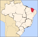
 Location in Ceará state | |
| Coordinates: 02°54′07″S 40°50′27″W / 2.90194°S 40.84083°W | |
| Country | Brazil |
| Region | Northeast |
| State | Ceará |
| Mesoregion | Noroeste Cearense |
| Microregion | Litoral de Camocim e Acaraú |
| Founded | September 29, 1879 |
| Government | |
| • Mayor | Monica Gomes Aguiar (PDT) |
| Area | |
| • Total | 1,124.78 km2 (434.28 sq mi) |
| Elevation | 8 m (26 ft) |
| Population (2020 [1]) | |
| • Total | 63,907 |
| • Density | 57/km2 (150/sq mi) |
| Demonym | Portuguese: Camocinense |
| Time zone | UTC−3 (BRT) |
| Postal code | 62400-000 |
| Area code | 88 |
| HDI | 0,620 |
| Website | www |
Camocim is a municipality in the state of Ceará, Brazil, founded in 1879. The population is 63,907 people (2020 estimate) in an area of 1,120.45 km2 (432.61 sq mi).[2]


