
Wapserveen: Difference between revisions
m Dating maintenance tags: {{Cn}} |
|||
| (35 intermediate revisions by 27 users not shown) | |||
| Line 1: | Line 1: | ||
{{Infobox settlement |
|||
{{Dutch town locator maps |
|||
| name = Wapserveen |
|||
| ⚫ | |||
| settlement_type = [[Village]] |
|||
| ⚫ | |||
| other_name = <!-- if different from name --> |
|||
| ⚫ | |||
| native_name = <!-- if different from name --> |
|||
| native_name_lang = |
|||
| image_skyline = File:Overzicht boerderij - Wapserveen - 20375494 - RCE.jpg |
|||
| image_alt = |
|||
| image_caption = Farm in Wapserveen |
|||
| image_flag = |
|||
| image_shield = |
|||
| nickname = |
|||
| motto = |
|||
| coordinates = {{Coord|52.8234|6.2132|type:city(268)|display=title, inline}} |
|||
| subdivision_type = [[List of sovereign states|Country]] |
|||
| subdivision_name = [[Netherlands]] |
|||
| subdivision_type1 = Province |
|||
| subdivision_name1 = [[Drenthe]] |
|||
| subdivision_type2 = Municipality |
|||
| subdivision_name2 = [[Westerveld]] |
|||
<!-- |
|||
| ⚫ | |||
--> |
|||
| ⚫ | |||
| ⚫ | |||
| map_caption = |
|||
| pushpin_map = Netherlands Drenthe#Netherlands |
|||
| pushpin_map_caption = Location in province of [[Drenthe]] in the [[Netherlands]] |
|||
| elevation_footnotes = <ref name="AHN">{{cite web |url = http://www.ahn.nl/postcodetool |title = Postcodetool for 8351GA |language = nl |work = Actueel Hoogtebestand Nederland |publisher = Het Waterschapshuis |access-date = 12 April 2022 }}</ref> |
|||
| elevation_m = 5 |
|||
| elevation_min_m = |
|||
| elevation_max_m = |
|||
| area_footnotes = <ref name="stat"/> |
|||
| area_total_km2 = 19.07 |
|||
| area_land_km2 = |
|||
| area_water_km2 = |
|||
| established_title = |
|||
| established_date = |
|||
| population_footnotes = <ref name="stat">{{cite web |url=https://www.cbs.nl/-/media/_excel/2021/48/kwb-2021.xls |title=Kerncijfers wijken en buurten 2021 |website=Central Bureau of Statistics |access-date=12 April 2022}}</ref> |
|||
| population_total = 790 |
|||
| population_as_of = 2021 |
|||
| population_demonym = |
|||
| population_note = |
|||
| population_density_km2 = auto |
|||
| population_density_urban_km2 = auto |
|||
| timezone = [[Central European Time|CET]] |
|||
| utc_offset = +1 |
|||
| timezone_DST = [[Central European Summer Time|CEST]] |
|||
| utc_offset_DST = +2 |
|||
| postal_code_type = [[List of postal codes in the Netherlands|Postal code]] |
|||
| postal_code = 8351<ref name="stat"/> |
|||
| area_code_type = [[Telephone numbers in the Netherlands|Dialing code]] |
|||
| area_code = 0521 |
|||
}} |
}} |
||
'''Wapserveen''' |
'''Wapserveen''' is a village in the [[Netherlands|Dutch]] province of [[Drenthe]]. It is a part of the municipality of [[Westerveld]], and lies about 21 km northwest of [[Hoogeveen]]. |
||
== History == |
|||
In 2001, the town of Wapserveen had 268 inhabitants. The built-up area of the town was 0.11 km<sup>2</sup>, and contained 121 residences.<ref name="CBS">Statistics Netherlands (CBS), [http://www.cbs.nl/nl-NL/menu/themas/milieu-natuur-ruimte/ruimte/publicaties/cartografie-geografie/geografische-data/2001-bevolkingskernen-in-nederland.htm ''Bevolkingskernen in Nederland 2001'']. (Statistics are for the continuous built-up area).</ref> |
|||
The village was first mentioned in 1395 or 1396 as Wasperveen, and means "[[peat]] excavation village belonging to [[Wapse]]".<ref>{{cite web|url=https://etymologiebank.nl/trefwoord/wapserveen |title=Wapserveen - (geografische naam) |website=Etymologiebank |access-date=12 April 2022 |language=nl}}</ref> Wapserveen is a road village near a peat excavation area.<ref name="monument"/> It was founded by colonists from [[Friesland]].<ref name="plaats"/> Large scale excavation did not start until the 17th and 18th century.<ref name="monument">{{cite book|url=https://www.dbnl.org/tekst/sten009monu07_01/sten009monu07_01_0097.php |title=Wasperveen |author=Ronald Stenvert |year=2001 |location=Zwolle |publisher=Waanders |isbn=90 400 9454 3 |language=nl |access-date=12 April 2022}}</ref> |
|||
The statistical area "Wapserveen", which also can include the surrounding countryside, has a population of around 880.<ref name="CBS2">Statistics Netherlands (CBS), [http://statline.cbs.nl/ ''Statline: Kerncijfers wijken en buurten 2003-2005'']. As of [[January 1]], [[2005]].</ref> |
|||
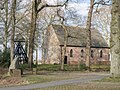
The Dutch Reformed church dates from 1803, but was built with bricks from its medieval predecessor. A separate bell fry was place on the cemetery around the same time.<ref name="monument"/> During the [[Reformation]], the Catholic church became Dutch Reformed and the priest was replaced by the minister Foppius Hilarii in 1606. The villagers preferred the priest, and Hilarii was killed by a farmer. The former priest was given a state [[pension]] in 1607 on the condition that he no longer practise and help the minister.<ref name="plaats"/> |
|||
Wapserveen was home to 617 people in 1840.<ref name="plaats">{{cite web|url=https://www.plaatsengids.nl/wapserveen |title=Wapserveen |website=Plaatsengids |access-date=12 April 2022 |language=nl}}</ref> In 1896, the cooperative dairy factory Wapserveen was built in the village.<ref name="monument"/> |
|||
==People== |
|||
[[Sicco Mansholt]], the former president of the European Commission (1972) and former European Commissioner for Agriculture between 1958 and 1972 lived after his career until his death in Wapserveen.{{cn|date=November 2022}} |
|||
== Gallery == |
|||
<gallery> |
|||
File:Exterieur overzicht, voorgevel, rechter zijgevel - Wapserveen - 20322640 - RCE.jpg|Farm in Wasperveen |
|||
File:Overzicht boerderij - Wapserveen - 20375496 - RCE.jpg|Farm and horse in Wasperveen |
|||
File:Hervormde kerk Wapserveen.jpg|Dutch Reformed church |
|||
</gallery> |
|||
==References== |
==References== |
||
<!--This article uses the Cite.php citation mechanism. If you would like more information on how to add references to this article, please see http://meta.wikimedia.org/wiki/Cite/Cite.php --> |
<!--This article uses the Cite.php citation mechanism. If you would like more information on how to add references to this article, please see http://meta.wikimedia.org/wiki/Cite/Cite.php --> |
||
<references/> |
<references/> |
||
{{Commons category|position=left}} |
|||
| ⚫ | |||
{{ |
{{Westerveld-town}} |
||
{{Authority control}} |
|||
| ⚫ | |||
[[nl:Wapserveen]] |
|||
[[ |
[[Category:Westerveld]] |
||
Latest revision as of 10:33, 3 November 2022
Wapserveen | |
|---|---|
 Farm in Wapserveen | |
 The village centre (dark green) and the statistical district (light green) of Wapserveen in the municipality of Westerveld. | |
 Wapserveen Location in province of Drenthe in the Netherlands  Wapserveen Wapserveen (Netherlands) | |
| Coordinates: 52°49′24″N 6°12′48″E / 52.8234°N 6.2132°E | |
| Country | Netherlands |
| Province | Drenthe |
| Municipality | Westerveld |
| Area | |
| • Total | 19.07 km2 (7.36 sq mi) |
| Elevation | 5 m (16 ft) |
| Population (2021)[1] | |
| • Total | 790 |
| • Density | 41/km2 (110/sq mi) |
| Time zone | UTC+1 (CET) |
| • Summer (DST) | UTC+2 (CEST) |
| Postal code | 8351[1] |
| Dialing code | 0521 |
Wapserveen is a village in the Dutch province of Drenthe. It is a part of the municipality of Westerveld, and lies about 21 km northwest of Hoogeveen.
History[edit]
The village was first mentioned in 1395 or 1396 as Wasperveen, and means "peat excavation village belonging to Wapse".[3] Wapserveen is a road village near a peat excavation area.[4] It was founded by colonists from Friesland.[5] Large scale excavation did not start until the 17th and 18th century.[4]
The Dutch Reformed church dates from 1803, but was built with bricks from its medieval predecessor. A separate bell fry was place on the cemetery around the same time.[4] During the Reformation, the Catholic church became Dutch Reformed and the priest was replaced by the minister Foppius Hilarii in 1606. The villagers preferred the priest, and Hilarii was killed by a farmer. The former priest was given a state pension in 1607 on the condition that he no longer practise and help the minister.[5]
Wapserveen was home to 617 people in 1840.[5] In 1896, the cooperative dairy factory Wapserveen was built in the village.[4]
People[edit]
Sicco Mansholt, the former president of the European Commission (1972) and former European Commissioner for Agriculture between 1958 and 1972 lived after his career until his death in Wapserveen.[citation needed]
Gallery[edit]
-
 Farm in Wasperveen
 -
 Farm and horse in Wasperveen
 -
 Dutch Reformed church


References[edit]
- ^ a b c "Kerncijfers wijken en buurten 2021". Central Bureau of Statistics. Retrieved 12 April 2022.
- ^ "Postcodetool for 8351GA". Actueel Hoogtebestand Nederland (in Dutch). Het Waterschapshuis. Retrieved 12 April 2022.
- ^ "Wapserveen - (geografische naam)". Etymologiebank (in Dutch). Retrieved 12 April 2022.
- ^ a b c d Ronald Stenvert (2001). Wasperveen (in Dutch). Zwolle: Waanders. ISBN 90 400 9454 3. Retrieved 12 April 2022.
- ^ a b c "Wapserveen". Plaatsengids (in Dutch). Retrieved 12 April 2022.