
Drenthe Province
|
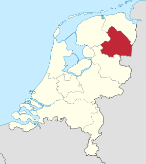
Drenthe Province of the Netherlands |
|
| coat of arms | flag |

|

|
| location | |
|---|---|
  |
|
| Basic data | |
| Capital | Aces |
| Biggest town | Emmen |
| ISO 3166-2 code | NL-DR |
| Website | www.drenthe.nl |
| anthem | Mijn Drenthe |
| politics | |
| Royal Commissioner | Jetta Klijnsma ( PvdA ) |
| Ruling parties | PvdA , VVD , CDA , GroenLinks and ChristenUnie |
| population | |
| Residents | 492,269 ( 10th of 12 ) |
| Country share | 2.8% of the Dutch |
| Population density | 187 inhabitants per km² ( 12th of 12 ) |
| Religion (2015, CBS ) | 11% Dutch Reformed 9% Roman Catholic 8% Protestant 5% Reformed 1% Islam 4% other 62% none |
| geography | |
| surface | 2,680.39 km² |
| - country | 2,632.65 km² (9th of 12) |
| - Water | 47.74 km² |
| height | up to 32 m above sea level NAP |
| Coordinates | 52 ° 52 ′ N , 6 ° 38 ′ E |
| Administrative division | |
| Communities | 12 |
| - of which cities | 3 |
 Topography of Drenthe |
|
Drenthe ( German Drente ) is a Dutch province in the northeast of the country. It borders in the south on the province of Overijssel , in the west on the province Friesland , in the north on the province Groningen and in the east on the German state of Lower Saxony . The province is rural and is dominated by moor areas in the east. Before Friesland, it is the most sparsely populated province in the Netherlands.
The capital is Assen with 67,986 inhabitants (as of January 31, 2019). Other important places are Emmen (the most populous municipality), Hoogeveen and Meppel . A Lower Saxon dialect is traditionally spoken in Drenthe .
geography
There are three types of landscape in the province. The heather in the western part, the moor areas in the eastern part and the canal landscapes .
pagan
The middle of the province, also known as Old Drenthe , has mainly sandy soil. This area is characterized by heather areas with pastures and arable farming, which were interrupted by strips of grassland along the rivers and streams. In the past, sheep farming predominated in agriculture , with sheep spending the summer in the heather. Through the use of artificial fertilizers from the 19th century onwards, sheep farming lost its importance and large parts of the heather were converted into agricultural land. Other parts of the heath were afforested by the state forest administration to meet the increasing demand for wood. The grassland along the rivers was mainly used as pastureland, with several floodplain areas being drained. The appearance of the arable land has also changed due to land consolidations .
So there is not much left of the original heathland. Larger areas can only be found in the Drentsche Aa National Park northeast of Assen .
Moorland

The eastern area of the province is dominated by moors . For a long time, intensive peat mining took place here. Large parts were crossed by drainage channels in order to enable mining. In the areas where the peat deposits were exhausted, agriculture settled. Today only two larger moors remain, the Bargerveen in the extreme south-east of the province and the Fochteloërveen in the north-west on the border with Friesland .
Canal landscapes
Since most of the rivers in the province were too small for shipping, numerous canals were built. The most important are the Drentsche Hoofdvaart , the Nord-Willemskanal , the Hoogeveense Vaart and the Oranjekanal . Due to the increasing traffic on the streets, the canals have lost their importance.
geology
On the surface, the province has the shape of an upturned oval plate. The edges are deep and the remaining parts are on an elongated plateau , the Drents Plateau . This consists largely of gravel deposits that are almost everywhere covered by sandy soils. The height of this plateau is between 10 and 20 m NAP . Only lakes and rivers create cuts. The surveys mostly come from strip dunes and landfills in building areas.
Between the cities of Emmen in the southeast and Groningen in the north runs the Dutch Hunsrück, the Hondsrug (dog's back), a slight elevation of ice-age sands and deposits. There is also the highest natural point in the province at 32 m. In the village of Wijster in the municipality of Midden-Drenthe, there is the highest artificial elevation in the province, at the top of a landfill. The lowest points are in the north and south-west below sea level .
In the village of Schoonebeek in the municipality of Emmen, crude oil has been produced since the 1940s. Funding was given up in 1996 for reasons of profitability and resumed in 2011. The operator is the NAM company. There are also natural gas deposits in the province that are also exploited by the NAM company.
history

In the Stone Age, people left places of worship consisting of large stones placed one on top of the other. These megaliths are called in Dutch hunnebed and the German giant's grave . 52 of the 53 megalithic sites in the Netherlands are located in Drenthe, only the 53rd is in the province of Groningen . As is usually the case , the facilities are built from boulders that the Ice Age deposited on the Hondsrug or in its vicinity.
The first written mention of Drenthe goes back to the year 820. The document speaks of a pago treanth , which stands for landscape Drenthe. 1024 and 1025, the county of Drenthe is mentioned in other documents. 1046 this county was by Emperor Heinrich III. given to Bishop Bernold of Utrecht . 1528 joined Bishop Henry II. Of Bavaria , the top pin Utrecht , to the territory of the present province of Drenthe belonged to Emperor Charles V from. In 1536 Drenthe became a separate rule within the Habsburg Netherlands. When the Republic of the Seven United Provinces declared itself independent, Drenthe became part of the country. However, it was not recognized as an independent province and part of the Overijssel province. Drenthe has been an independent province since the formation of the Kingdom of the United Netherlands (1815).
In the 19th century, Drenthe was still very isolated until wastelands and bog areas were tackled by colonization projects. Railways and canals opened up the area, such as the Oranjekanal (built from 1853 to 1861). In the 20th century, after the moors, the heather areas were also dismantled and large new businesses were established.

During the German occupation, the Westerbork transit camp was set up in 1942 ; originally it was a Dutch facility for Jewish refugees. Most of the Jews from the Netherlands who were later murdered were transported east via Westerbork, including Anne Frank in 1944 . Later the camp was used for Dutch collaborators , and from 1951 soldiers from the former colony of the Dutch East Indies and Moluccans who had worked for the Dutch colonial power lived here . The last families did not leave the camp until 1970. Since 1983 there has been a memorial center nearby.
In 1975 Moluccan youths kidnapped a train near the village of Wijster in the (today's) municipality of Midden-Drenthe . Two years later something similar happened at De Punt in the north of the province. The Moluccans were disappointed that the Dutch government could not realize their return to their islands of origin. In the first case the kidnappers had already murdered inmates, in the second there was a threat that the train would be blown up. Both times, the security authorities ended the kidnapping bloody.
politics
The Provincial Parliament ( Dutch Provinciale Staten ) has its seat in the Huis der Provincie in the provincial capital Assen . According to the population in the province, the parliament has 41 seats.
In the provincial election on March 20, 2019, the parties obtained the following voting shares: PvdA 14.06%, FvD 13.45%, VVD 13.05%, CDA 10.55%, GroenLinks 8.30%, PVV 7.05%, ChristenUnie 6.80%, SP 6.47%, D66 5.69%, Sterk Lokaal 4.09%, 50PLUS 3.70%, PvdD 3.43%, other 3.34%.
The next provincial election will take place on March 22, 2023.
At the head of the province is the king's commissioner . Since December 2017 this has been the social democrat Jetta Klijnsma . Since 1951, all those commissioned have been social democrats, previously mostly liberals. The college van Gedeputeerde Staten , i.e. the government, has been formed by a coalition of Social Democrats , right- wing liberals , Christian Democrats , Greens and Calvinists since 2019 .
Communities
When the municipalities were reorganized in 1998, the number of municipalities fell from 36 to twelve:

| No. | Name of the parish |
Pop. | Seat of the municipality |
|---|---|---|---|
| 1 | Aa en hunze | 25,359 | Gieten |
| 2 | Aces | 67,986 | Aces |
| 3 | Borger-Odoorn | 25,378 | Exloo |
| 4th | Coevorden | 35.504 | Coevorden |
| 5 | Emmen | 107.118 | Emmen |
| 6th | Hoogeveen | 55,699 | Hoogeveen |
| 7th | Meppel | 33,556 | Meppel |
| 8th | Midden-Drenthe | 33,190 | Hatching |
| 9 | Noordenveld | 31,286 | Clearing |
| 10 | Tynaarlo | 33,698 | Vries |
| 11 | Westerveld | 19,381 | The Ver |
| 12 | De Wolden | 24,114 | Zuidwolde |
(Residents on January 31, 2019)
economy
In 2011, the regional gross domestic product per inhabitant, expressed in purchasing power standards , was 99.03% of the EU-28 average . In 2017 the unemployment rate was 5.0%.
language
The original dialects are of Lower Saxony origin. This means that they do not belong to the main stream of those dialects that contributed to the development of modern Dutch. Lower Saxony is also spoken in the neighboring provinces of Groningen, Overijssel and Gelderland .
The dialects of the province are called Drents , especially those in the center. As everywhere in the Netherlands, the standard language is penetrating more and more areas of life.
Culture and science

Drenthe is known for its megalithic tombs. The Hünenbettzentrum in Borger deals with them and the culture of their builders . There is an open-air museum in Orvelte and the Drents Museum in Assen.
The Dutch TT motor race at Assen is also an internationally known sporting event . The Occultfest for hard rock and metal music has been held annually in Hoogeveen since 2002.
Perhaps the most important newspaper in the province is the Dagblad van het Noorden , which is also published in the neighboring province of Groningen .
The Westerbork Synthesis Radio Telescoop has been making astronomical observations since 1970. It also plays a role in Harry Mulisch's hit novel "The Discovery of Heaven". There is a planetary path near the antennas .
Individual evidence
- ↑ Religieuze betrokkenheid; kerkelijke gezindte; regio. CBS , December 22, 2016, accessed November 19, 2018 (Dutch).
- ↑ Tagesschau: Oil production again in "Texas" in the Netherlands ( Memento from January 27, 2011 in the Internet Archive ), January 24, 2011, accessed January 25, 2011.
- ^ Karl Heinrich Ludwig Pölitz : The Constitutions of the European States for the Last 25 Years , Volume 2, Leipzig, Brockhaus, 1817, p. 495 ( Google Books )
- ↑ Provinciale Staten 20 March 2019. In: Verkiezingsuitslagen.nl. Kiesraad , accessed May 1, 2019 (Dutch).
- ↑ Provinciale Staten 18 March 2015. In: Verkiezingsuitslagen.nl. Kiesraad , accessed May 1, 2019 (Dutch).
- ↑ Ze zijn eruit: Drenthe heeft een nieuwe coalitie. RTV Drenthe, May 20, 2019, accessed on May 25, 2019 (Dutch).
- ↑ Bevolkingsontwikkeling; regio per maand . In: StatLine . Centraal Bureau voor de Statistiek (Dutch)
- ↑ Eurostat yearbook of the regions 2014 : ( Chapter 5: Economy ; PDF, 18 pages, approx. 2.0 MB) and ( Eurostat source data for Chapter 5: Economy ; XLS format, approx. 536 kB), ISBN 978-92 -79-11695-7 , ISSN 1830-9690 (English)
- ↑ Unemployment rate, by NUTS 2 regions. Retrieved November 5, 2018 .
Web links
Free County of Burgundy | Imperial city Besançon | County Artois | County of Flanders and South Flanders (around Lille ) | Reign of Mechelen | Namur County | Hainaut county | County of Zeeland | County of Holland | Duchy of Brabant | Margraviate of Antwerp | Duchy of Limburg | Duchy of Luxembourg | Dominion Friesland | Tournai | Lordship of Breda | County of Hoorn | County Egmond | IJsselstein | Reign of Bergh
As well as from 1548 additionally: Duchy of Geldern | Zutphen county | Reign of Utrecht | Lordship of Groningen | Lordship of Overijssel and Drenthe | Rule of Jever (until 1588, before and later independent)
Provinces: Drenthe | Flevoland | Fryslân | Gelderland | Groningen | Limburg | Noord-Brabant | North Holland | Overijssel | Utrecht | Zeeland | South Holland
Organs: Provincial States | Put earth states | King's commissioner
Other: flags, pennants and coats of arms of the provinces of the Netherlands