
Drentsche Aa National Park
| Drentsche Aa National Park | |||
|---|---|---|---|
|
|||
| Location: | Drenthe , Netherlands | ||
| Next city: | Aces | ||
| Surface: | approx. 10,000 ha | ||
| Founding: | 2002 | ||
| Visitors: | 497,000 (2015) | ||
 |
|||

The Drentsche Aa National Park ( Dutch Nationaal beek- en esdorpenlandschap Drentsche Aa , literally translated National Stream and Angerdorf Landscape Drentsche Aa ) is a national park in the Dutch province of Drenthe . The approximately 10,000 hectare park is the third largest national park in the European part of the Netherlands in terms of area after the Oosterschelde and Nieuw Land national parks. On December 4, 2002, the National Stream and Anger Village Landscape Drentsche Aa was given the official status of a national park. The area has also been part of the Drentsche Aa national landscape, which is more than three times its size, since 2007 . The park has also been part of the European Natura 2000 network of protected areas since September 2013 . The national park is visited by around 500,000 tourists every year.
geography
The national park is located in the north of the province of Drenthe on the border with Groningen . The area is roughly triangular in shape, bounded by the N33 road to the south and the N34 to the east. In the west, the national park borders directly on the outskirts of Assen . The Dutch Autosnelweg 28 runs through the far north of the park .

The protected area belongs to the catchment area of the small river Drentsche Aa , which gave the national park its name. The special value of the landscape results primarily from the naturalness of the Drentschen Aa and its surroundings. The character of the area has not changed significantly since the middle of the 19th century , in particular the Drentsche Aa was not diked , which is very atypical for the rivers and streams of the Netherlands. The national park lies partly on the approximately 25-meter-high Hondsrug ridge , which stretches from the Drentschen Plateau to the Hogeland on the coast.
In addition to nature areas worthy of protection such as heathland , grasslands, small wooded areas and sand drifts , the park also includes De Strubben-Kniphorstbosch , the first archaeological reserve in the Netherlands. There are some barrows and burial mounds here . Within the boundaries of the national park there are also a total of 16 villages and hamlets with a total of around 10,000 inhabitants, of which Rolde and Tynarloo are the largest.
The former military training area Balloërveld is also part of the park area . This includes a higher plateau between two brooks on which today, in addition to the predominant heather, there are also some peat bogs . During the Second World War , this place belonged to the so-called "Frieslandriegel", a line of defense of the German armed forces against the Allied forces advancing from the west . Many of the anti- tank trenches built here for this purpose are still clearly visible today.
In the south of the national park there are four large, contiguous forest areas that were planted as a job creation measure during the Great Depression in the 1930s . Originally, the wood of the trees was supposed to be used in mining and industry , but this was never implemented. Instead, these forests are now an important tourist destination.
Emergence
The landscape that is visible today was mainly shaped during the Saale Ice Age around 200,000 to 130,000 years ago. During this cold period , glaciers penetrated from the north-west into what is now Drenthe and pushed large amounts of rock and clay in front of them. These were deposited on the border of the furthest extent and created the basis of today's ridge. After the ice began to retreat, large amounts of meltwater contributed to the erosion of the area. Many of the small streams that flow through the national park today were formed during this time.
Cultural and historical significance

Angerdörfer
The national park is home to a cultural landscape that has hardly changed since the middle of the 19th century . Here is a large number of so-called Anger villages (Dutch: esdorpen ), which stand out from other villages in that their houses have been planned around a central square, the Anger . The field was used jointly by all the villagers and was used, for example, to house livestock at night or to separate sick animals or animals that were ready for slaughter. In addition, a small lake was often created on the meadow, in which the village community used fish or water birds such as ducks and geese were kept. The Angerdörfer are surrounded by a special corridor shape that is still preserved today , the so-called Esch corridor . The term refers to higher-lying agricultural areas close to the farm, which were mostly operated as single-field farming and were usually fertilized with pests . In many cases, the wall hedges typical of this type of management are still visible today , which surrounded the arable land and were intended to protect against damage from cattle.
Megalithic buildings

Traces of prehistoric human settlement from up to 5000 years ago are visible in the national park. The most striking are the roughly 60 large stone graves from the Bronze Age , which can be viewed in the De Strubben-Kniphorstbosch archaeological reserve and on the former military training area Balloërveld . Furthermore, the area is also home to two so-called dolmens , the original purpose of which is now disputed.
flora
The Drentsche Aa National Park is home to not only the typical and common plants found in the heathland, but also some rarer plants, some of which are also on the red list of endangered species . One example is the black devil's claw , which only blooms between mid-May and mid-June and grows in some of the natural stream valleys. Other endangered species are about the Wechselblättrige Chrysosplenium and as a medicinal plant used arnica . Another special feature of the park are the numerous orchids that bloom from spring until June. These include species such as the spotted and broad-leaved as well as the overlooked orchid . In total, around 800 of the approximately 1400 plant species found in the Netherlands are found in the Drentsche Aa National Park.
fauna

The Drentsche Aa National Park provides a habitat for a number of animal species. Representatives of the mammals in the area include the deer , the wild rabbit and several types of voles . The stone marten has been spreading again in the area since the 1980s . The occurrence of the endangered water shrew in the area of the national park is of national importance. The introduced muskrat has experienced an explosive population development since the 1970s .
The park is also home to a population of European beavers that serve an important ecological purpose. In addition to other trees and shrubs, beavers repeatedly cut down specimens of the undesirable late blooming bird cherry . Originally from North America , this plant was introduced to the Netherlands about a hundred years ago and is now considered an invasive species .
Many species of birds find refuge in the area, especially due to the largely natural streams and less intensive agriculture. Some of the species found here are, for example, the common snipe , the tree pipit , the red-backed shrimp , the stonechat , the golden hammer or the common redstart .
The banded demoiselle , which has become rare in the Netherlands in recent years, but can be found in abundance again in the national park , also enjoys special protection status .
Status and administration
In other national parks, other concerns are usually subordinated to the protection and preservation of nature. Due to the outstanding cultural and historical importance of the Drentsche-Aa area, this is not the case here without restrictions. Instead, the park has a so-called "extended objective" (Dutch: brede doelstelling ), according to which the continuation of traditional agriculture and the quality of life in the villages within the park are on a par with nature conservation issues. For this reason, the feasibility of establishing a national park was debated for a long time, and the responsible ministry for agriculture, nature and food quality in the person of the then minister Cees Verman was only able to approve the granting of national park status through the creation of the special protection concept .
In 2002, the Ministry created the Overlegorgaan Drentsche Aa (for example: Advisory Committee Drentsche Aa) as the administrative body of the new national park . The body is subordinate to the provincial government of Drenthe and is composed of representatives from organizations such as the Dutch forest authority Staatsbosbeheer and the local Waterschappen as well as the communities that have a share in the park area.
gallery

A beaver in the Drentschen Aa

Forest with a small stream
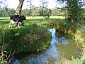
Livestock on the Amerdiep, one of the tributaries of the Drentschen Aa

Sunrise in the national park


literature
- Theo Spek: Het Drentse esdorpenlandschap. A historical-geographical study. Matrijs, Utrecht 2004, ISBN 978-90-8504-072-9 .
Web links
Individual evidence
- ↑ Nationaal Park en Nationaal Landschap Drentsche Aa. In: annodrenthe.nu. Retrieved August 9, 2018 (Dutch).
- ↑ Drentsche Aa region. In: alterra.nl. Ministerie van Landbouw, Naturr en Voedselkwaliteit, accessed on August 9, 2018 (Dutch).
- ↑ Bezoekersonderzoek State Forestry. In: recreatieschapdrenthe.nl. Staatsbosbeheer, June 16, 2016, accessed August 10, 2018 (Dutch).
- ↑ The Drentsche Aa. In: holland.com. Retrieved August 8, 2018 .
- ↑ Hoogtepunten National Park Drentsche Aa. In: drentscheaa.nl. Retrieved August 9, 2018 (Dutch).
- ↑ Sporen van de Tweede Wereldoorlog nog zichtbaar in Drenthe. In: drentheindeoorlog.nl. Retrieved August 9, 2018 (Dutch).
- ↑ Rich cultural history. In: drentscheaa.nl. Retrieved August 10, 2018 .
- ↑ Enno Bregman: Ontstaan van de Hondsrug en het Drentse Aa gebied. In: provincie.drenthe.nl. February 14, 2017, accessed August 8, 2018 (Dutch).
- ↑ Angerdorf. In: Spektrum.de. Retrieved August 9, 2018 .
- ↑ Christof Spannhoff: What is an Esch? In: wordpress.com. February 8, 2015, accessed August 9, 2018 .
- ↑ Over de Drentsche Aa. In: staatsbosbeheer.nl/. Retrieved August 8, 2018 (Dutch).
- ↑ Drentsche Aa (NP). In: natuurgebiedinbeeld.nl. Retrieved August 9, 2018 (Dutch).
- ↑ Drentsche Aa. In: knhs.nl. Retrieved August 10, 2018 (Dutch).
- ↑ Zoo animals. In: heugenvandrenthe.nl. Retrieved August 10, 2018 (Dutch).
- ↑ Lidian Bolens: Bever bestrijdt bospest in het Drentse Aa-gebied. In: dvhn.nl. August 25, 2016, accessed August 10, 2018 (Dutch).
- ↑ Henk van den Brink: Vogelparadijs Drentsche Aa. In: drentscheaa.nl. Retrieved August 10, 2018 (Dutch).
- ↑ Planets end in the Drentsche Aa area. In: drentscheaa.nl. Retrieved August 10, 2018 (Dutch).
- ↑ The Drentsche Aa - Verhalen. In: dehondsrug.nl. Retrieved August 10, 2018 .
- ↑ Overlegorgaan Drentsche Aa. In: drentscheaa.nl. Retrieved August 9, 2018 (Dutch).

European Netherlands: Alde Feanen | Biesbosch | Drents-Friese Wold | Drentsche Aa | Duinen van Texel | Dwingelderveld | Groote Peel | Hoge Veluwe | Kalmthoutse Heide | Lauwersmeer | Loonse en Drunense Duinen | Maasduinen | Meinweg | Nieuw Land | Oosterschelde | Sallandse Heuvelrug | Schiermonnikoog | Utrechtse Heuvelrug | Veluwezoom | Weerribben-Wieden | Zuid-Kennemerland
Caribbean Netherlands: Bonaire | Mount Scenery | Quill / Boven | Saba Bank | Saba Marine | Saint Eustatius | Washington Slagbaai
Curacao: Christoffel | Shete Boka
Aruba: Arikok
Sint Maarten: Man of War Shoal