
National Park De Loonse en Drunense Duinen
| National Park De Loonse en Drunense Duinen | |||
|---|---|---|---|
|
|||
| Location: | Noord-Brabant , Netherlands | ||
| Next city: | Loon op Zand | ||
| Surface: | approx. 3,500 ha | ||
| Founding: | March 28, 2002 | ||
| Visitors: | 1,200,000 (2015) | ||
| Address: | Van Tienhovenlaan 5 NL-5062 SK Oisterwijk |
||
 |
|||

The National Park De Loonse en Drunense Duinen is a nature reserve in the Dutch province of North Brabant . The area has a size of about 3,500 hectares and has officially been a national park since 2002. The park offers a variety of dry sand drifts and coniferous forest and also includes the extensive valley zone of the small river Zandleij. This is where the De Brand nature reserve is located, with its variety of coppice forest , wet meadows and swamp areas .
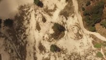
Most of the park (about 30 km²) consists of drift sand areas . The area is therefore also known as the "Brabant Sahara".
The area is surrounded by towns and smaller villages. The largest towns in the vicinity are the cities of 's-Hertogenbosch and Tilburg, about six kilometers away . To the west is Kaatsheuvel with the Efteling theme park .
geography
The national park is home to the largest drifting sand area in Europe with dunes, some of which were formed around 10,000 years ago. Temperatures in the drift sand areas can rise to 40 ° C in summer, while temperatures can drop to freezing at night.
In addition to the Loonse en Drunense Duinen itself, the park is divided into several sub-areas. These are:
- The Plantloon estate near Waalwijk . An extensive hiking area with agricultural areas and avenues. The lake Galgenwiel , which was created when the Maas dyke broke , is particularly well-known here .
- The De Brand wetland in the Zandleij valley.
- The Strijdhoef castle and estate also in the Zandleij area.
- The approximately 200 hectare Hengstven area in the east of the park with extensive flower meadows that are cultivated organically by farmers .
- The 's-Hertogenbosch-Drongelen drainage canal, which forms the northern boundary of the park.

history
Most of the sand drifts in the area originated in the Middle Ages , but some of the dunes are significantly older. Until the late Middle Ages , the area was able to feed modest farming communities, but at this time of relative prosperity, the population pressure increased so much that the area was destroyed by overgrazing and excessive use of the heather and an ever-increasing fallow land was created.
The erosion from agricultural activities was exacerbated by the consequences of warfare during the Eighty Years' War . The troops under the command of William of Orange used scorched-earth tactics in the area , which resulted in great famine in the area. The sandy bottom was exposed in more and more places so that the loose sand could be scattered by the wind. During this time, the sand buried entire settlements. The medieval villages of Efteling and Westloon are still buried today.
Oak trees have been planted since the 14th century to counteract the drifting sand. Pine and beach grass were used for this in the 18th and 19th centuries . Today the area is stable and trees are even felled to preserve the extraordinary landscape.
During the Second World War , soldiers of the Wehrmacht hid in the area of the Loonse en Drunense Duinen from the advancing Allied forces . Until the 1990s, the northeastern part of today's national park was used as a military training area.
On March 28, 2002, the area was officially granted national park status by the then Dutch Ministry of Agriculture, Nature and Fisheries .
tourism
The national park registers around 1.2 million visitors annually, making it the most visited nature area in the province of North Brabant. There is enough accommodation in the area around the park, but the park area itself is more suitable for day trips with the exception of two campsites. The national park is criss-crossed by a well-developed network of hiking and cycling trails, which are particularly well used when the weather is good. In the area there are also suitable routes for disabled people, as well as trails for riders and mountain bikes.
Flora and fauna

The fauna and flora of the Loonse- en Drunense Duinen is quite varied due to the different landscape forms in the park. Only a few plants grow in the dry sandy areas, while the transition zones to forest and heather are dominated by pioneer plants such as various mosses. A contrast to this is the De Brand marshland , where a large number of flowering plants such as the wood anemone , lesser celandine and marigold can be found.
The marshland is home to a large number of amphibians, including the northern crested newt . There is also a larger population of the European tree frog, which is rare in the Netherlands . Many bird species also live in De Brand , such as the water rail or the bluethroat . The oriole , bullfinch and various types of owls can be found in the forest areas .
The European badger has been successfully reintroduced to the area.
Because the national park is surrounded by settlements and other buildings, the migration opportunities for many animals are very limited here. There are plans to create connecting zones between the national park and other natural areas in North Brabant.
administration
The national park is managed by the Vereniging Natuurmonumenten and the Het Brabants Landschap and De Duinboeren foundations , as well as some private individuals.
Web links
- National park website (Dutch)
Individual evidence
- ↑ Loonse en Drunense Duinen - MAX Vandaag. Retrieved June 20, 2018 (Dutch).
- ↑ Loonse and Drunense Dunes National Park. Retrieved June 20, 2018 .
- ↑ Natural area Galgenwiel in de Loonse en Drunense Duinen, een oude doorbraakkolk van de Maas. Retrieved June 20, 2018 (Dutch).
- ^ Noord-Brabant: Natuur terug in het Hengstven. Retrieved June 20, 2018 (Dutch).
- ↑ Everything about De Prachtige Loonse en Drunense Duinen - Planjeuitje. Retrieved June 20, 2018 (Dutch).
- ↑ Oorlogsgeheimen van de duinen - Tilburg Wiki. Retrieved June 20, 2018 (Dutch).
- ↑ Loonse en Drunense Duinen - KNHS. Retrieved June 20, 2018 (Dutch).
- ↑ Ministerie van Landbouw, Natuur en Voedselkwaliteit: Regeling aanwijzing nationaal park De Loonse en Drunense Duinen. Retrieved June 20, 2018 (Dutch).
- ↑ Miljoenen bezoekers natuurgebieden eisen hun tol, maar maatregelen roepen weerstand op.Omroep Brabant, accessed on June 20, 2018 (Dutch).
- ↑ Europese Wandelingen - Loonse- en Drunense duinen, 11 km. Retrieved June 20, 2018 (Dutch).
- ↑ De Loonse en Drunense Duinen in Noord-Brabant - Nederland. Retrieved June 21, 2018 (Dutch).
- ↑ Het gaat goed met de dassen in Brabant | Natural monuments. Retrieved June 21, 2018 (Dutch).
- ↑ Deze veelbelovende natuurplannen maken van Langstraat walhalla explode voor. Retrieved June 21, 2018 (Dutch).
- ↑ De Brand. Retrieved June 21, 2018 (Dutch).

European Netherlands: Alde Feanen | Biesbosch | Drents-Friese Wold | Drentsche Aa | Duinen van Texel | Dwingelderveld | Groote Peel | Hoge Veluwe | Kalmthoutse Heide | Lauwersmeer | Loonse en Drunense Duinen | Maasduinen | Meinweg | Nieuw Land | Oosterschelde | Sallandse Heuvelrug | Schiermonnikoog | Utrechtse Heuvelrug | Veluwezoom | Weerribben-Wieden | Zuid-Kennemerland
Caribbean Netherlands: Bonaire | Mount Scenery | Quill / Boven | Saba Bank | Saba Marine | Saint Eustatius | Washington Slagbaai
Curacao: Christoffel | Shete Boka
Aruba: Arikok
Sint Maarten: Man of War Shoal