Saba National Marine Park
| Saba National Marine Park | ||
|---|---|---|
|
|
||
| Location: | Saba , Caribbean Netherlands | |
| Next city: | The bottom | |
| Surface: | approx. 1300 ha | |
| Founding: | 2010 | |
| The national park completely encloses the island of Saba. | ||
The Saba National Marine Park is a maritime national park in the Caribbean . It includes the waters around the island of Saba , one of the special municipalities in the Netherlands . The park was established in 1987 and received official national park status in 2010. It is administered by the Saba Conservation Foundation , which is also responsible for Saba's Terrestrial National Park .
geography

The Saba National Marine Park consists of the waters around Saba from the high water mark to a depth of 60 meters. This results in a total area of around 1300 hectares.
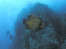
The national park is divided into four designated zones, which differ depending on the intended use. About a third of the park area is primarily designated as a diving area. The park contains some unusual rock formations that are interesting for divers, including the famous The Pinnacles and Diamond Rock. The so-called pinnacles are a volcanic structure that extends from a depth of approx. 100 meters to 27 meters below the water surface and is covered with colorful corals . The Diamond Rock is a rock off the west coast of Saba, which has a similar structure to the Pinnacles, but breaks through the water surface. The part protruding from the water is covered with a layer of guano and looks like it is covered with snow from a distance.
In the vicinity of Ladder Bay there is a lava- formed labyrinth of ditches and ledges. Directly west of the port of Fort Bay is the so-called Tent Reef . This is an unusual geological structure in the form of a wide rocky outcrop, which is only four meters below sea level near the coast, but slopes steeply to the northwest.
Flora and fauna
The waters of the national park offer different habitats with a high biodiversity . Particularly noteworthy here are Saba's coral reefs, which are formed from corals of the genera Montastraea , Agaricia , Colpophyllia and Diploria , of which the Montastraea species are the most numerous. The reefs are home to a myriad of species of fish, including saw bass , trigger fish , parrot fish , scorpion fish and moray eels . In addition to corals and fish, large numbers of invertebrates such as sponges , sea urchins , crabs and anemones live here .
Another significant habitat are the seagrass fields that occur in some places on the seabed, which are mainly formed by the species Thalassia testudinum and Syringodium filiforme as well as seaweed-forming green algae of the genus Halimeda . The seagrass meadows are important for many fish to lay their eggs and raise their young.
Sharks can often be seen in the more open water. The most common species are the Caribbean reef shark , the Atlantic nurse shark and the lesser blacktip shark . Hammerhead sharks and manta rays are also spotted occasionally . Sightings of whale sharks and migrating humpback whales have also been reported.
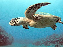
There are also two threatened species of sea turtles in Saba National Marine Park : the hawksbill sea turtle and the green sea turtle .
tourism
The national park has been a popular destination for diving tourists since the 1980s, primarily because of its coral reefs. Around 20,000 dives are recorded every year. The water in front of the island is pleasantly warm (mostly between 26 ° and 28 ° C) and clear. The minimum visibility under water is given as 20 meters. The ecotourism plays an important role in Saba's economy.
Furthermore, the waters around Saba are regularly approached by cruise ships. For smaller ships, especially yachts, a network of buoys has been installed to which the ships can moor without having to anchor. This is done to protect the coral reefs and seagrass beds from damage.
administration
The administration of the national park is the responsibility of the Saba Conservation Foundation (SCF for short), a non-governmental organization founded in 1987 and based in Fort Bay. Under the administration of the SCF, Saba National Marine Park is one of the few financially self-sustaining marine parks in the world, funded by entrance fees, souvenir sales, and donations. Access to the park is free for Saba residents, while divers and other tourists must pay a fee.
The park administration provides two decompression chambers that can be used in the event of diving accidents.
Web links
Individual evidence
- ↑ Eric G. Schultz, Stephen F. McCool, David Kooistra: Revisions to SMP Plan. Saba Conservation Foundation, accessed June 25, 2018 .
- ↑ Ruth Guimbellot, Barry Guimbellot: Exploring Saba: The Carribean's Unspoiled Queen. Retrieved June 25, 2018 .
- ↑ Saba National Marine Park - SITE DESCRIPTION - General and Physical Features. Retrieved June 25, 2018 .
- ↑ Saba National Marine Park - SITE DESCRIPTION - Biological Features. Retrieved June 25, 2018 .
- ^ Johan Schaeffer: Saba National Marine Park - Booming with Biodiversity. December 12, 2013, accessed June 25, 2018 .
- ↑ Assessing the Carrying Capacity of MPAs: How Many Visitors Can Your MPA Hold? | MPA News. Retrieved June 25, 2018 .
- ^ Saba Conservation Foundation - Diving. Retrieved June 25, 2018 .
- ^ Saba Conservation Foundation - Yachting. Retrieved June 25, 2018 .
- ^ Saba National Marine Park - MANAGEMENT - Legal framework, management body. Retrieved June 25, 2018 .
- ↑ Saba National Marine Park | DCNA. Retrieved June 25, 2018 (American English).
- ^ Jurisdiction Project - Island Studies, Saba. Retrieved June 25, 2018 .


