Fort Bay
| Fort Bay | |||
|---|---|---|---|
| Data | |||
| UN / LOCODE | BQ SAB | ||
| opening | 1972 | ||
| Port type | seaport | ||
| Piers / quays | 3 | ||
| website | www.sabaport.com | ||
| Geographic information | |||
| Special parish | Saba (island) | ||
| Country | Netherlands | ||
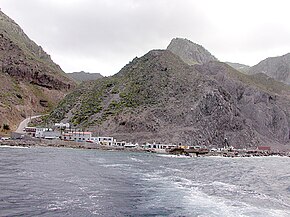
| Fort Bay in 2006 | |||
| Coordinates | 17 ° 36 '58 " N , 63 ° 15' 5" W | ||
|
|||
Fort Bay is the only port on the island of Saba , one of the Netherlands' special communities in the Caribbean .
history
Saba's geography only allows the safe landing of boats in a few places, as a large part of the island's coastline consists of cliffs that slope steeply towards the sea. The only notable exceptions are the Flat Point in the northeast of the island, on which Saba's international airport, the Juancho E. Yrausquin Airport , was built, the Ladder Bay on the west and Fort Bay on the southwest coast.

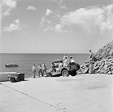
Until the 1930s there was only one building in Fort Bay, in which an officer euphemistically referred to as the "harbor master" resided, who was responsible for landing goods and people over the natural rocks that stretch out into the sea in the bay , monitored. Only when the plans for the construction of Saba's only paved road were concretized around 1934 did plans also emerge to develop Fort Bay into a real harbor. The idea was to connect the rocks in the bay to a pier using a ramp . Both this and a similar attempt in the 1950s, however, failed mainly due to the lack of technical expertise of the designers involved.
It was not until around 1970 that the Dutch engineering company Witteveen + Bos drew up technically feasible plans for the construction of a first pier and an associated breakwater , which were finally implemented by 1972. The lobbying work of Minister Leo Chance, a native of Saban who at the time was a member of the government of Curaçao , one of the other islands in the association of what was then the Netherlands Antilles , was decisive for the financing . The facility, named in honor of Chance, Captain Leo Chance Pier , was inaugurated on November 8, 1972 in a solemn ceremony.
In 2010, the port facilities in Fort Bay were expanded by the company Windward Roads infrastructure to include a 44 m long quay wall with a 230 m² boat ramp and a wall to protect against falling stones.
Saba is regularly hit by hurricanes . The Fort Bay facilities were damaged by Hurricane Lenny in 1999, among other things . The damage was so severe that it was still visible in places two years later.
The start of a major expansion of the port was originally planned for the first quarter of 2019: In addition to the Captain Leo Chance Pier , another, larger pier and an associated breakwater were to be built. In future, this should make it possible to handle the various types of incoming traffic such as fishing boats, ferries and cargo ships at separate landing stages. The project was expected to cost several million US dollars . After initial planning and tests for the expansion project, those responsible on the island determined that Fort Bay would not be able to meet the requirements of a permanently hurricane-proof port even with a corresponding expansion. The implementation of the expansions in the future is therefore questionable. More recent plans favor the construction of completely new docks at the so-called Black Rocks , which are located east of Fort Bay and could offer better protection from strong storms.
Facilities
Fort Bay is home to typical port facilities such as a boat filling station and the Sabanian office of the Dutch gendarmerie Koninklijke Marechaussee , which is responsible for customs and immigration issues on the island . The offices of the Saba Conservation Foundation , a non-governmental organization entrusted with the administration of the Saba National Marine Park and the Mount Scenery National Park , are also located here . A specialty is the Saba Marine Park Hyperbaric Chamber located in Fort Bay, which is a decompression chamber operated by the SCF . This facility, designed for four people, was opened in 1980 and has been supplying divers from the Eastern Caribbean in the event of diving accidents ever since. Furthermore, the former German lifeboat Erika has been stationed in Fort Bay since 2009 .
transport
The two ferries Dawn II (with home port Fort Bay) and The Edge (with home port Philipsburg ) connect Saba several times a week with the neighboring island of Sint Maarten . Fort Bay is also called once a week by the supply ship Mutty's Pride , which brings consumer goods and vehicles to the island, among other things.
Web links
Individual evidence
- ↑ Will Johnson: History. In: sabaport.com. Retrieved November 16, 2018 .
- ↑ Will Johnson: Captain Leo Chance Pier. In: thesabaislander.com. November 3, 2018, accessed November 16, 2018 .
- ^ New Quay Fort Bay Harbor Saba. In: windwardroads.com. Retrieved November 16, 2018 .
- ^ Fort Bay, Saba: A study on hurricane conditions. In: tudelft.nl. October 1, 2001, accessed December 17, 2018 .
- ^ Saba Starts Preparations For Big Harbor Project. In: curacaochronicle.com. March 7, 2018, accessed November 16, 2018 .
- ^ Saba Harbor may be Moved to New Location. In: bes-reporter.com. October 3, 2019, accessed November 14, 2019 .
- ↑ Facilities. In: sabaport.com. Retrieved November 16, 2018 .
- ↑ Learn about Saba's Nature. In: saba-news.com. Retrieved November 16, 2018 .
- ^ Staying Healthy on Saba. In: caribya.com. Retrieved November 16, 2018 .
- ↑ Sea rescue: “Erika” emigrates. In: mediamaritim.de. November 10, 2009, accessed December 17, 2018 .
- ↑ Travel Info. In: sabatourism.com. Retrieved November 19, 2018 .
- ↑ Shipping. In: sabaport.com. Retrieved November 19, 2018 .


