Utrechtse Heuvelrug National Park
| Utrechtse Heuvelrug National Park | ||
|---|---|---|
|
|
||
| Location: | Utrecht , Netherlands | |
| Next city: | Utrecht | |
| Surface: | approx. 10,000 ha | |
| Founding: | 2003 | |
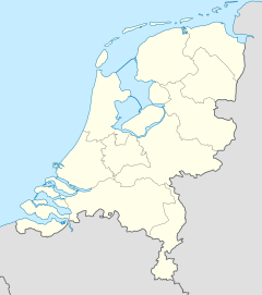
| National park map | ||
The Utrechtse Heuvelrug National Park is located in the province of Utrecht in the Netherlands . It is named after the forest area Utrechtse Heuvelrug ( German "Utrecht Hill Ridge") and borders the nature area "Gooisch Natuurreservaat" (municipality of Hilversum , province of North Holland ). The 60 km² southeast part in the municipalities of Heuvelrug , Veenendaal and Rhenen has been enclosed by the national park of the same name since 2003. In 2013, the area was expanded by a further 40 km², which connects to the previous area in the north and is located between the A12 and A28 motorways . The two parts of the park are connected by an Ecoduct .
landscape
The landscape consists mostly of forest. There are fewer hardwoods than conifers. It is a wooded sand ridge that emerged from a moraine in the penultimate Ice Age . At Amerongen there are valuable wetlands that form the transition to the polders of the river Lek .
The national park is heavily used by cyclists and hikers. There are many campsites, guest houses and small hotels. Tourism is primarily aimed at enjoying nature in peace. Important landowners, in addition to communities and noble families:
- the Association of Natural Monuments (Vereniging tot behoud van natuurmonumenten in Nederland)
- The Utrecht Landscape Foundation (Stichting Het Utrechts Landschap).
photos
Photo with Calluna vulgaris and others (the large picture is sensitive )
Web links
- National park website (Dutch)
- Natural Monuments Association (Dutch)
- Utrecht Landscape Foundation (Dutch)
Individual evidence
- ↑ Utrechtse Heuvelrug broad uit met 4000 hectare. In: volkskrant.nl. October 3, 2013, accessed October 25, 2019 (Dutch).


