
Veluwezoom National Park
| Veluwezoom National Park | |||
|---|---|---|---|
|
|||
| Location: | Gelderland , Netherlands | ||
| Next city: | Groenendaal | ||
| Surface: | approx. 5000 ha | ||
| Founding: | 1930 | ||
| Address: | Heuvenseweg 6A NL-6991 JE Rheden |
||
 |
|||

The Veluwezoom National Park is a nature area of around 5000 hectares in the Dutch province of Gelderland . It lies within the Veluwe , the largest contiguous forest area in the Netherlands, which is owned in its entirety by the Vereniging Natuurmonumenten . The park was opened in 1930, making it the oldest national park in the Netherlands.
The area consists mostly of varied forest, heather and some sand drifts . In the southern, mostly hilly part of the park, there are several estates such as Heuven and Beekhuizen . In the center of the park is the 90 meter high Posbank viewpoint . The nature reserve extends over the municipalities of Arnhem , Rheden and Rozendaal .
history
As the climate warmed after the end of the last glacial period , the area became covered with deciduous forest over time .
After the colonization by the first humans, most of the forest was cleared over the centuries or displaced by excessive grazing by sheep and cattle . This resulted in extensive heather areas such as the Herikhuizerveld and the Rheder- and Worthrhederheide . In the Middle Ages , all vegetation disappeared in some places and sand drifts such as the Rozendaalse Zand or the Rheder- and Worthrhederzand emerged . Only a few old coppice forest areas remained covered with forest all the time.
After the Middle Ages, various estates with parks and park forests were built in the fertile areas on the southern edge of today's national park. In the 19th century , trees were planted on the heathland and sand drifts, creating extensive pine forests in the northern part of the national park.
In 1911, the Hagenau forest area with the Carolinahof located in it was the first purchase by the Vereniging Natuurmonumenten in the area, followed by further forests and heather areas in the area. In 1930 the area was declared the Netherlands' first national park . To date, the nature reserve has been expanded as far as possible through further purchases of land.
geology
The subsurface of the area was largely shaped by the last two glacials . During the penultimate glacial period, the Saale Glacial , the existing sandy soils were dammed up into hills called ice - edge layers by the glaciers that penetrated into what is now the Netherlands from Scandinavia . These hills, like the Zijpenberg and the Posbank, are typical of the area today. The highest point is the approx. 110 meter high Signaal Imbosch , which lies north of the Zijpenberg in a forest.
When the glaciers at the end of the Saale glacial melted, deep depressions were washed out by the meltwater , which can still be clearly seen in the area around the Posbank. During the last glacial period, the Vistula Glacial , the glaciers did not penetrate into the Netherlands, but the wind carried sand and dust into the then bare landscape. The fine dust, which today forms a layer of fertile loess soil in the depressions in the south of the area, was deposited on the leeward side of the ice edge layers .
Flora and fauna
The flora of the park is mainly due to the existing soils and the management of the area in the past. On the moors grow heather , bell heather , gorse and broom . In ancient forests such as ' t Asselt and Onzalige Bossen , bracken grows under common oaks and birches . On the nutrient-poor sandy soils in the Imbosch area, the forest floor is mostly covered with blueberries and cranberries , while under the pines of the Eerbeeksche Veld and the Schaddevelden blueberries alternate with wire- smoked wreaths . In the forests on the richer loess soils in the south and east of the park, beeches , oaks and non-native tree species such as spruce , larch , common Douglas fir and sweet chestnut grow , whereby the trees can reach heights of up to 40 meters. Under the beech forests and avenues of beech that are common here , the ground is often completely devoid of vegetation. In the basin of the Beekhuizener Bach, there are also some special, characteristic plants such as the antiperspirant milkweed . In the barren parts of the Veluwe, the vegetation cover was often slightly removed and here and there extensive sand drifts with a very unique flora and (insect) fauna developed. Only the little Rozendaalse Zand remains in the Veluwezoom. In 2009, 17 hectares of forest were felled here to let the wind blow more freely again.
Some large mammals like red deer , fallow deer , roe deer and wild boar live in the national park . There are also predators such as fox , badger , ermine and the rare pine marten . Most of the bird species typical of forests and heathlands in the region are abundant. Even rarer species such as kingfisher , tree falcon , honey buzzard , common raven , goat milker , stonechat , skylark , green and black woodpecker can be observed. The northern gray shrike also occurs in winter .
Six of the seven indigenous in the Netherlands reptile species can be found in the national park: viper , smooth snake , grass snake , slow worm , sand lizard and the forest lizard .
administration

Until the mid-1980s, the national park was managed in a traditional, intensive way, with timber production and hunting activities being given a special position. Since then, the management of the park has been largely geared towards natural development. Most of the non-native plant species have been removed. The park administration is now primarily pursuing a strategy of non-interference in natural processes: trees and plants can look like each other in a natural way; fallen trees are not cleared. Dead animals are not removed either and can thus become part of the food chain . As a result of these measures, the number of scavengers and other organisms that feed on dead animals and plants has increased significantly. Furthermore, large grazers were introduced, which by eating trees and bushes ensure varied vegetation and the preservation of open areas in the national park. In the larger, northern part of the area these are Scottish Highland cattle , while in the southern part Icelandic horses take on this function. In most of the former arable areas, such as near Terlet , Groenendaal or Herikhuizen , agricultural use has now ceased.
Overall, the southern part of the national park is managed more intensively. The heathland there is preserved as a semi-natural landscape , for example by cutting plagues and removing trees.
The most intensive cultivation takes place on the estates along the southern edge of the national park. The maintenance of the culturally and historically significant goods, such as the existing parks with their avenues, bodies of water and groups of non-indigenous trees, plays an important role here.
Artificial, hand-dug streams, so-called "sprinkles", flow through the park in various places, which set windmills in motion until the steam engine appeared . A number of derelict blasting machines have now been restored.
Tourism and recreation
Ever since the population began to appreciate nature and the landscape around 1900, more and more tourists have been using the area for hiking . At the beginning, these were mainly wealthy residents from the west of the country, who often spent several months in the surrounding villages during the summer. As the 20th century progressed, the area attracted increasing numbers of people from across the country and from large parts of the population. The Posbank gained national fame as a destination for many day trips during this period.
Thanks to its extensive network of trails, the national park is ideal for hiking, cycling and horse riding . Several hiking, cycling and riding trails have been laid out in the area, including a route specially designed for mountain bikes.
On the southern edge of the park, near the village of Rheden, is the Veluwezoom visitor center , from which various routes lead into the park. In the center of the national park there are two dining establishments: the Paviljoen de Posbank tea house and the Carolinahoeve pancake restaurant .
Two observation huts were built in the national park to observe wild animals: One on the edge of the former agricultural enclave Herikhuizen, from where you can see the ruins of a former farm. The other on the Elsberg, from which one has a wide view of the Rheder- and Worthrederheide and the surrounding forests. Many visitors come here in autumn to watch the red deer rutting .
gallery

Typical heathland
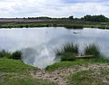
Small lake in the park area
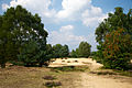
Sand drift in the Roosendaalse Heide
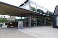
The Veluwezoom visitor center
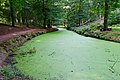
Artificially created stream (Sprenge)


Web links
- National Park Veluwezoom Official website of the national park
Individual evidence
- ↑ Op pad met de boswachter van Nationaal Park Veluwezoom - WandelMagazine.nu. Retrieved June 13, 2018 (Dutch).
- ↑ Veluwezoom National Park . December 14, 2011 ( holland.com [accessed June 13, 2018]).
- ↑ National Park Veluwezoom | Natural monuments. Retrieved June 13, 2018 (nl-NL).
- ↑ The Veluwe - up and down through forest, heather and sand . In: ALL-ROUND INSIGHT THE NETHERLANDS . June 25, 2017 ( wordpress.com [accessed June 13, 2018]).
- ↑ Zijpenberg (107 m). Retrieved June 13, 2018 .
- ↑ Fred Daniëls, R Ketner-Oostra: Post-excursion Kootwijkerzand and National Park de Hoge Veluwe (Netherlands) . In: TUEXENIA . January 1, 2014 ( researchgate.net [accessed June 13, 2018]).
- ↑ Natuur. Retrieved June 13, 2018 (Dutch).
- ↑ Schoppers, Jan: Vogels van de Veluwezoom . Ed .: Vogelwerkgroep Arnhem en omstreken. Arnhem, ISBN 90-812483-1-6 .
- ↑ Wilderness development with large grazing animals? Retrieved June 13, 2018 .
- ^ The "New Forest" system. Retrieved June 13, 2018 .
- ↑ Honderd jaar Veluwezoom: het begon met Hagenau. Retrieved June 13, 2018 (nl-NL).
- ↑ Liemers en Veluwe . In: Waterschap Rijn en IJssel . ( wrij.nl [accessed June 13, 2018]).
- ↑ Wandelen. Retrieved June 13, 2018 (Dutch).
- ↑ Bezoekerscentrum Veluwezoom | Natural monuments. Retrieved June 13, 2018 (nl-NL).

European Netherlands: Alde Feanen | Biesbosch | Drents-Friese Wold | Drentsche Aa | Duinen van Texel | Dwingelderveld | Groote Peel | Hoge Veluwe | Kalmthoutse Heide | Lauwersmeer | Loonse en Drunense Duinen | Maasduinen | Meinweg | Nieuw Land | Oosterschelde | Sallandse Heuvelrug | Schiermonnikoog | Utrechtse Heuvelrug | Veluwezoom | Weerribben-Wieden | Zuid-Kennemerland
Caribbean Netherlands: Bonaire | Mount Scenery | Quill / Boven | Saba Bank | Saba Marine | Saint Eustatius | Washington Slagbaai
Curacao: Christoffel | Shete Boka
Aruba: Arikok
Sint Maarten: Man of War Shoal